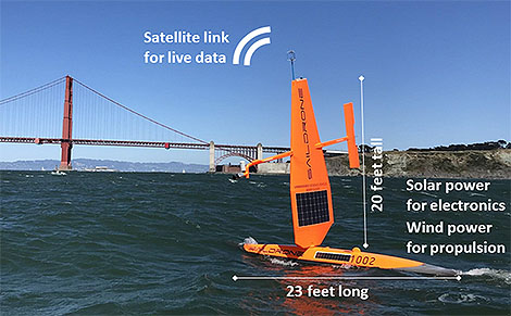
You’ve heard of drones in the air, but how about on the ocean’s surface? Enter Saildrone: A new wind and solar powered ocean-observing platform that carries a sophisticated suite of scientific sensors to observe air–sea fluxes. Looking like a large windsurfer without the surfer, the sailing drone glides autonomously at 2–8 kts. along the surface of uninhabited oceans on missions as long as 12 months, sampling key variables in the marine environment.
In a recent paper published in the Bulletin of the American Meteorological Society, author Chelle Gentemann and her colleagues explain that from April 11 to June 11, 2018, Saildrone cruised on a 60-day round trip from San Francisco down the coast to Mexico’s Guadelupe Island to establish the accuracy of its new measurements. These were made to validate air–sea fluxes, sea surface temperatures, and wind vectors derived by satellites. The automated surface vehicle also studied upwelling dynamics, river plumes, and the air–sea interactions of both frontal and diurnal warming regions on this deployment—meaning Saildrone’s versatile array of instruments got a workout not only above surface but just below it as well, in the water along the hull.
BAMS asked a few questions of the authors to gain insight into their research as well as their backgrounds. A sampling of answers are below:

BAMS: What would you like readers to learn from your article?
Chelle Gentemann, Farallon Institute: New measurement approaches are always being developed, allowing for new approaches to science. Understanding a dataset’s characteristics and uncertainties is important to have confidence in derived results.
BAMS: How did you become interested in working with Saildrone?
Gentemann: The ocean is a challenging environment to work in: it can be beautiful but dangerous, and gathering ship observations can require long absences from your family. I learned about Saildrones in 2016 and wanted to see how an autonomous vehicle might be able to gather data at the air–sea interface and adapt sampling to changing conditions. There are some questions that are hard to get at from existing remote sensing and in situ datasets; I thought that if these vehicles are able to collect high-quality data, they could be useful for science.
BAMS: How have you followed up on this experiment?
Gentemann: We sent two more [Saildrones] to the Arctic last Summer (2019) and are planning for two more in 2021. There are few in situ observations in the Arctic Ocean because of the seasonal ice cover, so sending Saildrones up there for the summer has allowed us to sample temperature and salinity fronts during a record heat wave.
Sebastien de Halleux, Saildrone, Inc.: I believe we are on the cusp of a new golden age in oceanography, as a wave of new enabling technologies is making planetary-scale in situ observations technically and economically feasible. The fact that Saildrones are zero-emission is a big bonus as we try to reduce our carbon footprint. I am excited to engage further with the science community to explore new ways of using this technology and developing tools to further the value of the data collected for the benefit of humanity.
BAMS: What got you initially interested in oceanography?
de Halleux: Having had the opportunity to sail across the Pacific several times, I developed a strong interest in learning more about the 70% of the planet covered by water—only to realize that the challenge of collecting data is formidable over such a vast domain. Being exposed to the amazing power of satellites to produce large-scale remote sensing datasets was only tempered by the realization of their challenges with fine features, land proximity, and of course the need to connect them to subsurface phenomena. This is how we began to explore the intersection of science, robotics, and big data with the goal to help enable new insights. Yet we are only at the beginning of an amazing journey.
BAMS: What surprises/surprised you the most about Saildrone’s capabilities?
Peter Minnett, Univ. of Miami, Florida: The ability to reprogram the vehicles in real time to focus on sampling and resampling interesting surface features. The quality of the measurements is impressive.
Saildrones are currently deployed around the world. In June 2019 , there were three circumnavigating Antarctica, six in the U.S. Arctic, seven surveying fish stock off the U.S. West Coast and two in Norway, four surveying the tropical Pacific, and one conducting a multibeam bathymetry survey in the Gulf of Mexico. In 2020, Saildrone, Inc. has deployed fleets in Europe, the Arctic, the tropical Pacific, along the West Coast, the Gulf of Mexico, the Atlantic, the Caribbean, and Antarctica. NOAA and NASA-funded Saildrone data are distributed openly and publicly.