All the research ships and aircraft of atmospheric science may never be able to gather in one place for testing. But small, portable unmanned aircraft systems (UAS) are another matter. An international vanguard of scientists developing these atmospheric observing capabilities is finding that it is really helpful to get together to pool their insights—and devices—to accelerate each other’s progress. Together, their technology is taking off.
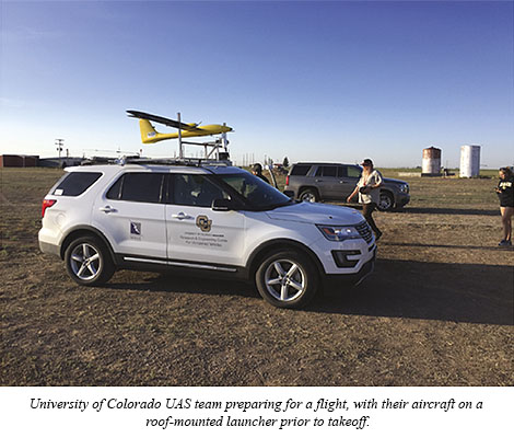
In the May 2020 BAMS, Gijs de Boer (CIRES and NOAA) and colleagues overview one of these coordinate-and-compare campaigns: when 10 teams from around the world brought 34 UAS to Colorado’s San Luis Valley for a week of tests, laying groundwork for new collaborations and future field programs. The July 2018 flight-fest conducted 1,300 research flights totaling more than 250 flight hours focused on observing the intricacies of the lower atmosphere.
Dubbed the LAPSE-RATE campaign—Lower Atmospheric Profiling Studies at Elevation–A Remotely-Piloted Aircraft Team Experiment—it was one of the fruits of a new community of scientists, the International Society for Atmospheric Research Using Remotely-Piloted Aircraft (ISARRA).
 At a “Community Day,” the scientists shared their aircraft and interests with the public as well. Working together all in one place has huge benefits. The teams get to see how they compare with each other, work out the kinks with their UAS, and move faster toward their research goals. It’s one reason they are getting so good so fast.
Below, de Boer answers some questions about the campaign and how he got started with UAS.
BAMS: What are some of the shared problems revealed by working together—as in LAPSE-RATE—with other UAS teams?
Gijs de Boer: There are common problems at a variety of levels. For example, accurate wind sensing has proven challenging, and we’ve definitely worked together to improve wind estimation. Additionally, different modes of operation, understanding which sensors are good and which are not, and sensor placement are all examples of how the community has worked together to lift up the quality of measurements from all platforms.
BAMS: What are the most surprising lessons from LAPSE-RATE?
GdB: I think that the continued rapid progression of the technology and the innovation in UAS-based atmospheric research is impressive. Some of the tools deployed during LAPSE-RATE in 2018 have already been significantly improved upon.
BAMS: What are some examples of this more recent UAS improvement?
GdB: Everything continues to get smaller and lighter. Aircraft have become even more reliable, and instrumentation has continued to be scrutinized to improve data quality. Battery technology has also continued to improve, allowing for longer flight times and more complex missions.
Yet, we have so much more to do with respect to integrating our measurements into mainstream atmospheric research.
BAMS: What are some challenges to doing more to integrate UAS into research?
GdB: Primarily, our UAV research community is working to demonstrate the reliability and accuracy of our measurements and platforms. This is critical to having them accepted in the community. There are also some other challenges associated with airspace access and development of infrastructure to interface these observations in both mainstream research and operations.
BAMS: It seems like there’s been success in this mainstreamed usage of UAS.
GdB: Campaigns like LAPSE-RATE have paved the way for UAS to be more thoroughly included in larger field campaigns. A nice example is the recent ATOMIC (Atlantic Tradewind Ocean–Atmosphere Mesoscale Interaction Campaign) and EUREC4A (Elucidating the role of clouds-circulation coupling in climate) field campaigns, where three different UAS teams were involved and UAS were operated alongside manned research aircraft and in support of a much larger effort.
BAMS: How did you become interested in unmanned aviation?
GdB: In 2011, I worked with a small group on a review article about our knowledge of mixed-phase clouds in Arctic environments. We took a good look at critical observational deficiencies, and I began to realize that many of the gaps involved a lack of in situ information, quantities that I thought could be measured by small platforms. This sent me down the road of investigating whether UAS could offer the necessary insight.