Accepting Nominations for the 2012 Harry Wexler Award

A meeting focused on technology. A commitment to look back at where we’ve been and where we’re going. Striving for a “Janus moment,” as Mark Brooks put it so eloquently.
This is clearly a propitious moment to ask: Who should win the AMS Harry Wexler Award for 2012?
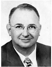
Wexler: He brought transformative technology into operational meteorology.

But, wait a minute, you say. AMS doesn’t give out a Harry Wexler Award! No problem: The Front Page is going to take a downright impertinent, not to mention unconstitutional–if it weren’t imaginary–step to solve that. Join us in this honorary thought experiment.
First things first, though…if you don’t know who Harry Wexler was, you’re in luck. We’ve reserved a front row seat for you at not one, but two presentations in New Orleans. The first is the keynote of the History Conference on Tuesday (11 a.m., Room 245), which will be given, appropriately, by James Rodger Fleming.
A meteorologist-turned-history professor, Fleming’s recent book, Fixing the Sky, won the 2012 AMS Battan Award and is an essential addition to your collection of Wexleriana. His topic in New Orleans is, “Transformative Technologies and International Cooperation in the Career of Harry Wexler “. Transformative technology? Now that’s a Janus moment indeed. Pure Wexler.
Ever wanted to fly into a hurricane? Wexler was the first scientist to do it. Heard of global warming? Back in the 1950s Wexler helped support the landmark carbon dioxide observational record we now call the Keeling curve. Heard of the ozone hole? Wexler was delivering talks about how humanity could wipe out the polar stratospheric ozone layer more than a decade before chemists made us look askance at CFC-laden hairspray canisters. Wondering if we’ll have to geoengineer climate to avoid catastrophic climate change? Wexler was already considering options.
Here are some of the transformations Wexler kick-started into high-octane development and ultimately operations while he was head of research at the Weather Bureau before his untimely death at age 51, in 1962:

  • General circulation modeling
  • Weather satellites.
  • Numerical weather prediction

Impressive list. That last one is the focus of your second Wexler-focused presentation, Robert Thomas Golden Canning’s “Modernization and Innovation in the Weather Bureau,” (Tuesday, 1:45 p.m., Room 335/6).
Mind you, Wexler didn’t invent these things. He wasn’t the one doing the research. He wasn’t even the one identifying the applications. But he was good at listening–as a skilled organizer, inspiring manager, astute judge of ideas and their advocates, and a versatile, agile thinker. According to Canning, Wexler “had an insatiable appetite for learning and scientific discussion, whether about meteorology, oceanography or even (as his daughter recalls) dinosaurs.”

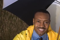
Glackin: She brought transformative technology into operational meteorology, too.

So it seems fitting that we initiate this year–the 50th anniversary of Wexler’s death and just one past the 100th of his birth–with a meeting celebrating technology, past and future. Judging from the papers you’re writing and the presentations you’re giving, there are a lot more Harry Wexlers out there than ever, some in leadership positions, some working quietly to usher new ideas into practice.
Feel free to share your nominations. Since we’re presumptuous enough to announce a fictitious award, however, you can be sure that we have some people in mind already. AMS Policy Program Director Bill Hooke mentions one in his blog this week, telling us that this particular AMS Fellow

started with NOAA back in the 1970’s before even completing her education, at the most junior level.  Over the years she steadily rose through the ranks. She contributed substantially to and ultimately led the development and the implementation of the Advanced Weather Interactive Processing System. AWIPS is the IT workhorse of the NOAA/NWS infrastructure that enables our national weather-readiness.

Anyone who’s had that kind of daily impact on forecasting technology earns serious gratitude and a nod to Wexler’s legacy. Kudos to you, Mary Glackin, on your career at NOAA and your retirement this Friday.
The Next Steps for the USGCRP

This week, the National Research Council issued a report of a blue-ribbon panel arguing that the United States Global Change Research Program (USGCRP) may not be able to meet the new decadal goals it’s setting for itself. In less than two weeks, in New Orleans, you’ll get a chance to have your say, too.
USGCRP guides research and disseminates information about climate change, and comprises 13 governmental agencies ranging from the Department of Defense to NASA. The USGCRP assists policymakers; federal, state, and local decision makers; and the public in understanding and adapting to global change.
The program’s new 10-year plan (see draft here; a final version is due next month) broadens USGCRP’s scope from climate to include “climate-related global changes,” building “from core USGCRP capabilities in global climate observation, process understanding, and modeling to strengthen and expand our fundamental scientific understanding of climate change and its interactions with the other critical drivers of global change, such as land-use change, alteration of key biogeochemical cycles, and biodiversity loss.”
The new strategic plan was created to help promote four primary goals of the Program:

  • advance scientific knowledge of the integrated natural and human components of the Earth system;
  • provide the scientific basis for timely adaptation and mitigation;
  • build sustained assessment capacity that improves our understanding, anticipation, and response to global change; and,
  • broaden public understanding of global change.

At the AMS Annual Meeting in New Orleans, a Town Hall Meeting (Tuesday, 12:15 p.m., Room 239) will discuss the new strategic plan and examine forthcoming USGCRP initiatives, including integrated modeling and observations, an interagency global change information system, adaptation research, and the National Climate Assessment. The meeting will also discuss how attendees can become involved in USGCRP activities, and will review current and future products, tools, and services that might be useful to both scientists and decision makers.
Implementation of the decadal strategy won’t be without its challenges, however. The recent National Research Council report praises the USGCRP’s ambition in expanding its scope, but  it also points out that the Program needs greater expertise in certain areas to sufficiently undertake its new plans.

The USGCRP and its member agencies and programs are lacking in capacity to achieve the proposed broadening of the Program, perhaps most seriously with regard to integrating the social and ecological sciences within research and observational programs, and developing the scientific base and organizational capacity for decision support related to mitigation and adaptation choices. Member agencies and programs have insufficient expertise in these domains and lack clear mandates to develop the needed science.

Additionally, the NRC report notes the lack of overarching governance in the USGCRP, which prevents a cohesive foundation of research areas among the Program’s 13 contributing agencies. As a result, those agencies tend to focus on their own pet projects.
“We were hoping there would be a way to coordinate better, especially on the congressional side,” says NCAR’s Warren Washington, who chaired the NRC committee that prepared the report.
Ultimately, the NRC report notes that “a draft federal plan to coordinate research into how to respond to climate change is unlikely to succeed without added resources and new ways to manage the Program.”
“We do recognize there are some gaps in our capacity,” says the NSF’s Timothy Killeen, the USGCRP vice chair who helped develop the new strategic plan. Program officials welcomed the recommendations outlined in the report and have already made plans to bring in more expertise from academia and other agencies to augment research areas that are lacking, as well as form interagency working groups that could help unify the Program.

Oh Weather, Where Is Thy Sting?

A word of warning to the victorious.
Election results are in, and as reported on the AMS web site, J. Marshall Shepherd of the Univ. of Georgia is our new President-Elect. He’ll become President for a year starting at the 2013 Annual Meeting.

AMS President-Elect J. Marshall Shepherd: Fortunately for us, allergic to bees, not thunderstorms.

But…first, Shepherd must survive our upcoming meeting, which will transform the New Orleans Convention Center into a buzzing hive of meteorological activity.
The first big test of the President-Elect’s resolve will be the temptation to check out the poster by Paul Croft et al. on Monday 23 January (2:30 p.m.-4 p.m., Hall E) about how students have been tracking insect species as part of an overall study of cranberry bog restoration in New Jersey and how this might affect local weather. Then there’s a poster on Thursday (9:45-11 a.m., Hall E) by Sarah Tessendorf (NCAR) et al. on how pine bark beetles affect the microclimate (and ultimately snowpack) in Colorado mountain forests.
But the real test will be “The Vector Mosquito Aedes Aegypti At the Margins,” presented by Andrew Monaghan (NCAR) et al. Monday at 2 p.m. (Room 333). Monaghan and his colleagues have taken their research to the hinterlands to solve the question of what environmental and social factors affect breeding and movement of mosquitos carrying Dengue Fever.
Simple measures of temperature changes or degree days might work in tracking the behavior of some mosquito borne disease (like the outbreaks of West Nile Virus in the American Midwest), but they aren’t adequate in this sensitive climate-health interaction run amuck.

In the last decade, the Americas have experienced a dramatic increase in severe disease cases (dengue hemorrhagic fever), with devastating public health consequences. Of particular concern is the potential for the expansion of intense dengue virus transmission into cooler, high altitude cities that are presently outside of transmission zones but may be at risk under scenarios of climate change, such as Mexico City.

We’ll remind Dr. Shepherd that this research is no clean and pure modeling exercise: NCAR tells us that Monaghan and other researchers have been poking through trash such as old tires in Mexico looking for pools of water where mosquitoes might fester.

Because the dengue-carrying mosquito only breeds in urban areas, a key challenge is understanding how human behavior and infrastructure influence mosquito populations in combination with climate.  Even if climate change eventually creates favorable conditions for the dengue mosquito’s survival in new areas, societal factors—such as the amount of time people spend outdoors, whether they use screens in their homes, and whether they have reliable access to piped water and municipal trash collection—may hinder the mosquito’s survival in new areas, or its ability to transmit dengue to humans.

Why recommend insect avoidance when it all sounds so intriguingly interdisciplinary? It turns out that Dr. Shepherd, who is well known for his research on climate and land surfaces, originally intended to be an entomologist:

It wasn’t a flash of inspiration but a rather a sting-a bee sting, to be exact-that got Shepherd interested in meteorology. [A]s a child growing up in Canton, Ga., he dreamed of becoming an entomologist. Discovering the hard way that he was allergic to bee stings led him to consider other options, and the success of a middle school science fair project-in which he constructed weather instruments from scratch and used them to forecast the weather in his neighborhood-revealed a talent that would blossom into a career.

Congratulations, Dr. Shepherd! And we promise not to bug you about this again.

Slick Science: How Storms Spread Oil Spills

“The Deepwater Horizon explosion reopened debate on the role of synoptic weather features versus ocean currents in transporting the oil spill,” says Pat Fitzpatrick of Mississippi State Univ. in his abstract for a presentation in the upcoming AMS Annual Meeting.
This debate is a result of conflicting experiences with oil spills in windy storms. A storm notoriously expanded the Exxon Valdez oil slick in Prince William Sound in 1989, but on the other hand Hurricane Henri in 1979 basically had little effect on the plume of the Ixtoc spill and paradoxically cleaned up soiled Texas beaches.
We’ll know what chances this case has of settling the debate over how winds and storms move oil slicks around after seeing the data Fitzpatrick presents (Monday, 23 January, 4:30 p.m., Room 337) from the 2010 disaster in the Gulf of Mexico. For now, Fitzpatrick writes, “Lagrangian models generally assume oil concentrations travel largely proportional (80-100%) to ocean currents’ speed and direction, plus an additional 3% contribution from surface winds, diffused with each time step. However, cyclones are known to highly perturb water pollutants….”
Add another finding to this mix, however: A paper published this week in the Proceedings of the National Academy of Sciences confirms previous reports that most of the oil in the Deepwater Horizon disaster never made it to the surface. Of course, it makes sense that oil plumes from an undersea explosion might stay underwater. In this case, scientists say, the plumes consisted of microscopic particles of pollution–invisible to the naked eye (with or without a scuba mask). More than a third stayed deep in the Gulf; a quarter of the is unaccounted for. From the Sarasota Herald Tribune:

“The visible surface slick that people were riveted by during the months of the spill was really only 15 percent of the total mass,” said Thomas Ryerson, a research chemist with the National Oceanic and Atmospheric Administration who led the study.

It will be interesting to see if such varying conditions of oil releases from different disasters over the years will add up to a coherent understanding of the interaction of ocean and atmosphere that can be used to improve predictions of the movement and effects of the next big spill.

The Return of the Ozone Layer

It’s always nice to hear good news: The ozone layer is recovering, and by around 2032 the amount of ozone in the atmosphere should return to 1980 levels, according to the 2010 Scientific Assessment of Ozone Depletion. At last fall’s symposium on Stratospheric Ozone and Climate Change, co-sponsored by AMS, Paul Newman gave a talk about this progress–and what the world would have looked like had the landmark Montreal Protocol not been implemented in 1987.  Here’s his message, in a nutshell, courtesy of a NASA video:

(You can see Newman’s in-depth presentation on the Assessment from the Bjerknes Lecture at the AGU Fall Meeting as well).
Comprehensive data are available in the links, but a couple of highlights from Newman’s talk are that 1) amounts of chlorine and bromine in the lower atmosphere are in decline, and 2) if the Montreal Protocol had not been implemented in 1987, two-thirds of the ozone layer would be have disappeared by 2065, while the UV index would have tripled. Not only would this have led to a marked increase in occurrences of skin cancer and other health problems, but it also would have caused crop yields across the world to decline by up to 30%, potentially leading to food shortages.
The technology used in ozone research will be the topic of a number of presentations at the upcoming AMS Annual Meeting in New Orleans. One device of particular interest is the Ozone Mapper Profiler Suite (OMPS), a state-of-the-art instrument onboard the recently launched NPOESS Preparatory Project (NPP) satellite.
Angela Li of NASA and colleagues will discuss the collection and evolution of OMPS data in a presentation titled “End-to-End Ozone Mapper Profiler Suite (OMPS) Mission Data Modeling and Simulation” (Tuesday, 1:45 p.m., Room 343/344).
Glen Jaross of Science Systems and Applications, Inc. will lead an examination of the calibration of instruments like OMPS in the discussion, “Evolution of Calibration Requirements and Techniques for Total Ozone Mappers” (Tuesday, 8:30 a.m., Room 257).
Lawrence Flynn of NOAA/NESDIS will lead a talk (Monday, 5:00 p.m., Room 245) on recent advances in ozone sensors, with a focus on those that make solar Backscatter measurements in the Ultraviolet–a list that includes not only OMPS but also the EuMetSat Global Ozone Monitoring Experiment (GOME-2), the Chinese Meteorological Administration (CMA) Solar Backscatter Ultraviolet Sounders (SBUS) and Total Ozone Units (TOU), and the NOAA Solar Backscatter Ultraviolet instruments (SBUV/2).
Early results from OMPS and other instruments on NPP will be the subject of a panel discussion (Monday, 12:15 p.m., Room 343/344) of NPP science team members and designers.


Science for Oysters…and Oysters for Scientists

One of the highlights of New Orleans is its distinctive, world-renowned cuisine. And indulging in that famous cuisine more often than not means enjoying the bounty of the Gulf of Mexico. AMS members will descend on New Orleans right at the high season for oysters, according to food critic Brett Anderson writing in the local paper, the Times-Picayune, right before Christmas:

Meteorologically speaking, it is an inconvenience that Louisiana oysters are never more delicious than they are right about now, just as we’re growing accustomed to the daily threat of something resembling winter. Wouldn’t it be nice if oysters were at their crispest in August instead, when they could provide cool relief from the blood-hot sun? Yes, that would be nice, but our reality is pretty sweet as well: oysters at their peak, tasting like clean ocean water, firm-fleshed and sitting pert on their shell. They’re perfectly sized, large enough to announce their presence, small enough to swallow whole. Get another dozen. It’s gift-giving season.

According to the reports from the restaurants, the local crop is back to the quality seen before the big BP Horizon oil spill of 2010. Prices and supplies have normalized.
So while you’re hunting for some Gulf oysters on the half-shell later this month at the AMS Annual Meeting, keep in mind that this delicacy is not only featured on your plates but, also, featured on scientific program. In particular, two presentations might ease concerns you have about subjecting your stomach to the raw variety (of food, not science, of course!). Gina Ylitalo (NOAA) and colleagues will present on “Oil Spills and Seafood Safety” (8:45 p.m., Tuesday, Room 333). They write

Thousands of seafood samples collected during reopening and surveillance in the Gulf, as well as those obtained dockside and in the marketplace have been analyzed using [advanced] analytical methods. While chemical compounds associated with the oil spill have been detected in seafood samples using these various analytical methods, none were present in edible tissues at levels that approached levels of concern for human consumers of seafood products from the Gulf.

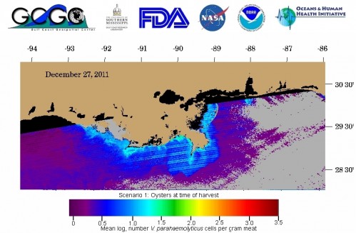
Later in the same session on Tuesday, Jay Grimes (Univ. of Southern Mississippi) will talk about monitoring disease potential from raw seafood with satellite monitoring of ocean temperatures and salinity, in “Can You Really See Bacteria from Space?”.  Below is the latest bacteria estimate from their oceanographic monitoring website:

Space-based monitoring of a notorious bacteria in seafood that can cause illness in certain disease-prone diners. Right now threat levels are relatively low in the Gulf, which, presumably, means good times in New Orleans for oyster lovers.


The Hazards of the Winter Roads

We all know winter is a tough time for drivers, not only with wet and icy roads but also with poor visibility due to more dark hours, low sun angles, valley fogs, or blowing snow.
Right there you have two different problems: adverse road conditions, and adverse atmospheric conditions.
Which hazard is more of a seasonal phenomenon, and which is the greater risk to drivers? And given regional variations in winter conditions, how do the risks change with your location and time of year? Do risks depend on whether you’re driving a big or small vehicle?
Recently, Allan Curtis of the University of Lincoln and his colleagues have been putting a quantitative edge to such questions by analyzing more than 100,000 fatal crashes, one-fifth of them with commercial trucking. Some results so far that they’ll present Wednesday, 25 January (10:30 a.m., Room 348/49) at the AMS Meeting in New Orleans include:
  • 17% of all fatal accidents and 7,130 persons are killed in weather-related accidents each year.
  • The Midwest has the greatest average intra-annual variability for both trucks and passenger vehicles. For large commercial trucks, the average monthly peak occurs in January with 38.29% of accidents occurring with adverse-weather, and a minimum in June of 8.27%. For passenger vehicles, accidents are less affected by adverse-weather with an average intra-annual peak of 30.28% in January and a minimum of 6.32% in June.
  • The South has the least average intra-annual variability of accidents in adverse-weather.
  • Adverse-road related accidents are greater in all regions than adverse-weather due to the fact that accidents can occur on wet or snow/ice covered roads in the absence of adverse-weather.
One can imagine taking Curtis et al.’s data and parsing out when the forecasts for road conditions are likely to be more meaningful to drivers than forecasts for the weather itself, among other applications. Stay tuned for the presentation in a few weeks.

New Study Now Quantifies the "Huge" Seafloor Movement in 2011 Japanese Earthquake

At a magnitude of 9.0, the earthquake off the Japanese coast last March was already known as one of the most powerful ever recorded, killing (in large part due to the ensuing tsunami) almost 16,000 people and damaging or destroying more than 125,000 buildings. A recent study (available here; subscription required) now quantifies just how monumental the event was: the seafloor in the Japan Trench northeast of the mainland, where the quake originated, was jolted 50 meters horizontally and 10 meters vertically–movement that was “abnormally, extraordinarily huge,” according to Toshiya Fujiwara of the Japan Agency for Marine-Earth Science and Technology.
Fujiwara led the research that used multibeam bathymetric surveys to measure the depth of the water and contouring of the seafloor. He noted that the research team did not expect to be able to use such equipment to detect the crust movement,which during most earthquakes occurs in scales of millimeters or centimeters. For example, the 2005 Miyagi earthquake, which had a magnitude of 7.2, registered a crustal shift of 10 centimeters at a geodetic station near the Japan Trench. The 2011 earthquake had a shift of 15 meters at the same station. The study also found another vertical shift of at least 4-6 meters of a slab of ocean crust between the Japan Trench and the Japanese coastline, which may have contributed to the pulsating pattern of the tsunami waves that eventually struck the country.
The researchers believe that the fault that caused the quake may extend as far as the axis of the Japan Trench.
“Previously, we thought the displacement stopped somewhere underground,” Fujiwara said, “but this earthquake destroyed the entire plate boundary.”
As we posted previously, a number of presentations at the AMS Annual Meeting in New Orleans will cover the community response to the earthquake and tsunami, including Junichi Ishida of the Japan Meteorological Agency who will discuss the earthquake’s impact, the JMA’s response to it, and lessons learned from the disaster in the keynote address for the 28th Conference on Interactive Information Processing Systems (Monday, 11:00 a.m., Room 356).

Weather Alerts Get More (and More) Mobile

The use of social media as a forecast tool seems to develop as rapidly as the devices themselves. In December, the NWS revealed it will soon be providing customized location-specific alerts through a user’s wireless carrier.
“We’re getting this weather, disaster, and other emergency information into your hand,” says David Green of the NWS. “The new service will use geo-location to target alerts to a person’s whereabouts. The goal is to give people greater insight into what’s going on with the weather so they can make the best decisions about how to respond.”
At the AMS Meeting in New Orleans next month, you can get a look at two more ways mobile devices are being used to aid in forecasts. In “Using Mobile Devices to Display, Overlay, and Animate Meteorological Data and Imagery,” David Santek, CIMSS/University of Wisconsin, and colleagues, will show their custom interfaces for smartphones that offer near real-time weather alerts. For more on the details of their applications and the future plans for it, check out their presentation on Monday, 23 January, at 5:00 p.m. (Room 357).
Marcel Molendijk, of the Royal Netherlands Meteorological Institute, offers up a different use in “iWitness; Damage Assessment of Severe Weather by Mobile (phone) Observations.” Instead of sending weather alerts to cell phone users, Moldendijk and colleagues collected accident damage reports from an Apple iOS application they developed, with information including a description of the event, time and location (GPS-based), and an optional photo. To get more information on the KNMI system and the results collected to date, go to the talk on Tuesday, 24 January at 2:30 p.m. (Room 356).

After the Disasters, How to Be a Holiday-Ready Nation

Weather took hundreds of lives in a record 12 billion-dollar disasters in the United States in 2011. Internationally, the disaster toll is even more startling. Tragedies have been a commonplace. The record-breaking year is a wake up call to the weather and climate community and to the nation as a whole.
Yet, on a holiday eve, a veteran of some of the worst weather of the year shows us how to give thanks. It was at a meeting, “Weather Ready Nation: A Vital Conversation” this month in Norman, Oklahoma, in an emotional presentation by Keith Stammer. If anyone knows what it means to be Weather-Ready, now, it’s Stammer, the emergency manager of Jasper County, Missouri, where basically a third of the city of Joplin was ripped apart by an EF-5 tornado nearly a mile wide.  (You can listen to Stammer’s description of the ordeal on-line.) Yet here’s how he started his talk:

The big thing you need to understand about Joplin is that at nighttime it is a city of 50,000 people; in the daytime it’s a city of a quarter of a million.  A lot of people come in for shopping, medical, for work. The one thing that translates, into in terms of this particular disaster, was that we are most grateful that it happened on Sunday evening, and not Monday evening, or the totals would have been absolutely different.

That’s a remarkable perspective to take after 162 people died, over a thousand were injured, and nearly 17,000 dwellings were lost. It’s a way to live after a year like 2011.
The discussion about making this country more resilient to the battering and bruising of a violent atmosphere, begun in Norman, will continue at our meeting in New Orleans next month. A Monday lunchtime Town Hall by the same name, organized by the leaders of the Norman conference, will be a highlight (12:15 p.m., Room 238). After Christmas, we’ll report on some of the Weather Ready Nation ideas and comments in The Front Page as preparation for the week’s deliberations.
But before refueling our minds for the Annual Meeting, a holiday is a time to replenish the heart and to experience community, so listen again to Stammer, who ended his talk thanking the 114,677 different people who stepped forward, registered as volunteers, and put in some 697,817 hours of service so far to help Joplin recover (more than a million cubic yards of debris removed so far):

All disasters are local, they start locally; they end locally, they may in fact rise to national prominence somewhere in between as ours did, but in the end, with all due respect, all of you foreigners are going to go away and we’re still left to have to handle it.  I think one of the things that helped us here is the fact that everybody was willing and able to look at this as a local effort. I can tell you that we did not have one organization or person that stood up and said, I’m in charge, you’re not, get over it. It was in fact a collaborative effort from the get-go and remains to be so today.

We are honored to celebrate a holiday with folks like that. We will be proud to make a Weather Ready Nation with them, too.