Pathways from Meteorology–Political, Commercial, Personal

The path from good science to good societal decisions is the central paradigm not only of the scientist’s perspective on how to impact the world, but also to the public’s faith in science itself. It also turns out to be a path of personal growth as well.
There’s a whole genre of attempts to depict these connections between science and its usage. One noteworthy example of such diagrams was published by the Bulletin of the American Meteorological Society back in 2002. John Dutton (now of Prescient Weather, Ltd.; then dean at Penn State University), saw a need to update the flow of scientific information from numerical models to decision makers. He recognized the increased use of computerized decision models that were interpreting scientific forecast input; he also wrote eloquently about the feedback and blurring between economic sectors, users, and scientists. Here’s what he came up with:
DuttonWxDecisionModel
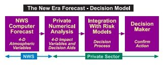
While Dutton’s focus was on expanding economic opportunity, he wrote with a palpable sense of inexorably widening horizons from that kernel of numerical weather modeling into all corners of societal activity: “Wider distribution leads to enhanced creativity and advancing capability as a thousand flowers bloom,” Dutton wrote.
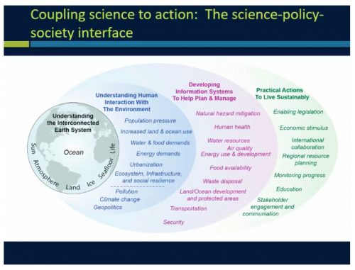
That same vision of the expansive horizons, all stemming from a mere act of meteorology, infused Susan Avery’s address to the AMS Student Conference in Austin this year. Only in this case, it is a parallel to Dutton’s economic view–a rippling from science to policy to society. In her talk, titled “Usable Science: Connecting Science to Action,” Avery, president emerita of Woods Hole Oceanographic Institute, depicted the pathway from science to society as a personal journey. Her ever-widening ellipses show an expansion of opportunities, knowledge, and horizons throughout a career as you move beyond the possibilities of a scientific education.
AveryCouplingSciencePolicySociety
 
She explains:

Often those pathways, those learning opportunities, those experiences come about by the sciences themselves, and the evolution of the science. Believe it or not, the demands right now for you and predictive information—it’s not just about the weather forecast anymore.
I know this is the American Meteorological Society and everybody thinks it’s all about weather, but this Society itself, which has been an inspirational part of my personal and my professional growth, it also isn’t just about the weather anymore and the daily weather forecast.
I’d like you to think broadly as you go through your life and your career. Some of these learning experiences you might have will allow you to evolve your thinking in terms of what is knowledge of the atmosphere and how does it apply to something else other than the daily forecast.
Part of this idea of coupling science to use is associated with understanding the interdependency of what you’re trying to do and what you’re trying to solve. I like this diagram because—it looks kind of complicated—but it’s really the only one I can think of in trying to understand what is this connection between science, policy, society, and use.
First of all, the atmosphere is only one part of our planetary system. A lot of the atmospheric motions there are because of ocean-atmosphere interaction. You have to understand there’s an ocean driver there as well. When you worry about how that plays out in terms of people, you have to worry about where we live, on the land….A lot of atmospheric science departments today are really Earth system science departments. The science is pushing us that way.
If you want to apply that science to solving problems, it’s pretty important to understand what those problems are and the interdependencies particularly between the planet system and humans. So that second ellipse talks about those interdependencies—particularly population pressure, societal desires, and what that means in terms of consumption patterns, water use, energy use, where you live. We are a human forcing function on that planetary systems.

And so to the third ellipse and on to the last as the knowledge pushes us. Dr. Avery explained, “These are just some of the pathways that you might see yourself taking in the future.”
You now can hear Avery’s whole talk online.

Survivors Meet the Storm

As  Typhoon Hagupit (Ruby) headed their way this weekend, Filipinos began to show they were a people far too experienced in the ways of typhoons.
Anxiety mixed with prudence. 500,000 people evacuated to safer quarters. Many residents of Tacloban–the city hardest hit by last year’s disastrous Typhoon Haiyan—took shelter in the local stadium. Others stocked up with food and other supplies. The city’s deputy mayor told the BBC, “It’s stirring up a lot of emotions in our hearts and bringing back so many painful memories.”
Those who study severe weather warnings are increasingly noticing this phenomenon: whether by fear or familiarity, people with prior experience have a peculiarly complex reaction to impending severe weather.
For example, a succession of well predicted tornadoes hit central Oklahoma within a short span in May 2013. During the third outbreak of that period, public reaction went awry. Before meteorologists could warn of the dangers of fleeing by car, residents hit the roads and caused potentially catastrophic traffic jams. The spontaneous evacuation, unlike any seen previously for a tornado, exposed the public to great risks.
In a paper to be presented at the AMS Annual Meeting next month at the Phoenix Convention Center (Wednesday, 7 January, 11:15 a.m., Room 226AB), Julia Ross and colleagues will analyze the effects of experience on the public’s “freak out” response to these tornadoes.
Quoting a recent paper by Silver and Andrey in the AMS journal, Weather, Climate, and Society, Ross et al. note that direct experience with hazards amplifies risk perception.  But their survey results show both reasoned and fear-driven reactions to the warnings—and possibly some regionally specific preferences as well.
(In the presentation to follow Ross et al. at the Annual Meeting, Lisa Dilling and colleagues analyze the opposite of a wary, seasoned public. They report on the effect of surprise in the Boulder, Colorado, floods last year.)
If anyone knows typhoons, it’s the people of the Philippines. Supertyphoon Haiyan, which killed 7,000 a year ago, was but one of six different tropical cyclones that have killed more than 1,000 Filipinos in the past decade.
This time around authorities say they’re aiming for zero casualties. But there’s more than just anxiety to deal with. It takes time to rebuild from a blow like Haiyan. A Haiyan survivor in Tacloban told the Associated Press, “I’m scared. “I’m praying to God not to let another disaster strike us again. We haven’t recovered from the first.”
 

One Year Later, Sandy Still Resonates

The scars from Superstorm Sandy remain evident, even a year after it blasted the North Atlantic coast. In some areas, the cleanup and rebuilding continue in very tangible ways, while for others, the damage cannot simply be repaired with tools and lumber. And while the healing continues, so also does the effort throughout the scientific and emergency planning communities to understand exactly what happened—and to ensure we’re better prepared for the next storm.
At NCAR, scientists have been studying simulations of Sandy in the Advanced Hurricane WRF, NCAR’s hurricane-oriented version of the Weather Research and Forecasting model. Some of their research was discussed at August’s AMS Conference on Mesoscale Meteorology, and a paper detailing their work will be published shortly in Monthly Weather Review. Their key finding was that Sandy combined elements of many familiar phenomena that “hadn’t been previously shown to come together in such a way near a major coastline,” according to NCAR’s Bob Henson, who detailed the findings in this article. He wrote:

Strong winter storms at sea sometimes develop pockets of warm air within their cold cores—a process known as warm seclusion, first characterized by Shapiro and Daniel Keyser. However, in this case, the warm air being secluded was already present in Sandy’s inner core. This is the first time such a dramatic warm seclusion has been documented in a landfalling U.S. hurricane.

While Superstorm Sandy was a highly unusual phenomenon from a scientific standpoint, it also presented new and unique challenges in other ways; for example, its path through the northeast United States took it through heavily populated–and in some cases, particularly vulnerable–areas.  Sandy’s impact on the built environment makes it an especially appropriate example of the theme of the 2014 AMS Annual Meeting in Atlanta. During that meeting, the lessons that Sandy reveals about future extreme events will be explored at a special conference titled “Superstorm Sandy and the Built Environment: New Perspectives, Opportunities and Tools.” This conference will focus on three complementary elements of the storm: prediction and preparedness; response and recovery; and, particularly, new perspectives, opportunities, tools, and imperatives for the future built environment. The broad range of topics to be discussed include storm evolution and prediction; communication about the storm through the media; impacts on lives, property, and infrastructure; and preparation and response. The complete schedule for the conference can be found here.

Upping the Ante on Modeling Climate Change Impacts

There is a growing urgency to produce global projections of how a warming climate could affect life on Earth.
“Impact research is lagging behind physical climate sciences,” says Pavel Kabat, director of the International Institute for Applied Systems Analysis (IIASA) in Austria. “Impact models have never been global, and their output is often sketchy. It is a matter of responsibility to society that we do better.”
Time is running out for researchers hoping to contribute impact simulations to the IPCC’s Fifth Assessment Report (scheduled for publication in 2014). So last month, the IIASA and the Potsdam Institute for Climate Impact Research (PIK) started a project to compare climate-impact models collected from more than two dozen research groups in eight countries. The Inter-Sectoral Impact Model Intercomparison Project (ISI-MIP) will integrate climate data from state-of-the-art models, using a range of greenhouse-gas emission scenarios (models used in the project can be found here). Because the various emissions scenarios result in a range of projected global temperature increases, potential impacts also can vary widely across a range of scenarios. It is hoped that the project will clarify systematic biases that can cause models to produce disparate results.
The models will investigate the effects of climate change on global agriculture, water supplies, vegetation, and health. Results are due by July 1, and reports on each of the four impact areas are scheduled to be completed by January of 2013. This means the data could be available for the IPCC’s next report–which “will make a real difference for the assessment process,” notes Chris Field of the Carnegie Institution for Science, cochair of IPCC Working Group II. “I greatly appreciate the initiative required to get this activity underway, and I appreciate the commitment to fast-track components that will yield results in time for inclusion in the IPCC Fifth Assessment Report.”
The ISI-MIP is scheduled to continue into 2013 and could be expanded to analyze climatic impacts on transport and energy infrastructures.
 

A model developed by PIK combined precipitation and temperature projections from 19 general circulation models to predict global vegetation loss. The results are shown in this map under two different warming scenarios.

How Much Was That Forecast Worth?

Despite the general good fortune that the storm stayed out at sea, there are plenty of grumblings about the cost of Hurricane Earl and more specifically the cost of preparing for it:

Last week’s storm was forecast to be the strongest to hit Long Island’s East End in nearly twenty years. And to handle possible outages, the Long Island Power Authority brought in 1,600 workers from out of state, at an estimated cost of $30 million. LIPA’s budget — already reeling from combating four major storms earlier this year — is now even further in the red.

(Fortunately, LIPA wisely understands the risks that Earl posed:

However, because the storm was supposed to hit such a wide area, LIPA says if it had to do it all over again, it still would’ve brought in those extra workers.)

And further north:

Airlines canceled dozens of flights into New England, and Amtrak suspended train service between New York and Boston….Massachusetts officials estimated that Cape Cod lost about 10 percent of its expected Labor Day weekend business, but were hopeful that last-minute vacationers would make up for it. Gov. Deval Patrick walked around Chatham on Saturday morning, proclaiming, “The sun is out and the Cape is open for business.”

So, as a palliative while people continue to grouse about paying the costs of meteorological uncertainties, read Mike Smith’s post about the savings this time when 450 miles of coastal warnings were issued compared to the much broader-brush (1,500 coastline miles warned) for Hurricane Floyd in 1999.

Instead of warning the entire East Coast as we had to during Floyd, the science of meteorology correctly identified that only the two areas (outer banks and far east Massachusetts) were at risk and warned accordingly. The forecast change in Earl’s direction of movement and rate of weakening were both remarkably good considering this forecast was two days out.

Taking NOAA’s calculations for evacuation costs per mile of coastline, and a reduction of 1,050 miles of warnings in similar situations, and do the math:

OK, now take those 1,050 miles and multiply them by a conservative figure of $700,000 in savings for each mile that correctly was not warned = $735 million dollars! ….And, when you figure in the value-added private sector hurricane forecasts issued by companies like WeatherData and its parent company AccuWeather, the savings grow further, perhaps approaching a billion dollars in total when the correct landfall forecast for Canada is factored in.

Clearly this depends on whether people actually evacuated based on the warnings, but the progress is clear, nonetheless, as are the positive benefits of recent improvements in track forecasts.