He was boots on the ground after Hurricane Michael slammed the panhandle as a Category 5 with 160 mph winds on October 10, 2018, assisting the Tallahassee NWS office with surveying the widespread wind damage that extended well away from the coast. Because Michael was intensifying at landfall as well as accelerating, its extreme winds spread deep inland, across the panhandle and well into southwest and southern Georgia.
The Donalsonville, Georgia, airport northeast of Marianna, Florida, and about 90 miles inland, recorded a wind gust to 115 mph, while Marianna had a gust to 103 mph in Michael. Both as well as Blountstown, Georgia, suffered significant damage to structures as well as trees.
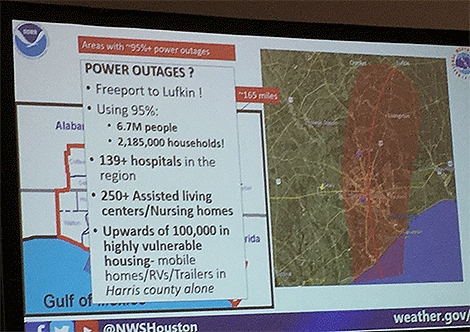
Track and power outage extent map from Hurricane Michael overlaying a map of Houston. What 95% of the Houston Metro area without power would equate to.
Evans overlaid maps of Michael’s track, wind swath, and areal power outages on Houston to show the extent of its damage potential. The entire Houston metro area with 7.1 million people would suffer; 6.9 million would lose power. And damage to homes and devastation to the landscape would mimic the widespread destruction he observed in the Florida panhandle and southern Georgia where entire forests were virtually flattened.
Evans said that as an NWS meteorologist responsible for warning the Houston area if such a scenario threatened he would have a lot of trouble following the standard hurricane mantra, “Run from the water, hide from the wind.”
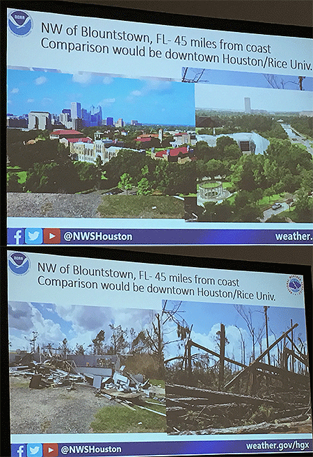
Rice University in the Houston Metro area is about the same distance from the coast as Blountstown, Florida, which was blasted by Hurricane Michael.
“Telling people inland to stay put in such extreme wind conditions is not something I would want to do,” he says.
But, he adds, telling them to get out could prove just as deadly in the mass exodus.
“When you start talking about storms, such as Rita, with 130 mph winds or higher, it’s a spontaneous evacuation.” More than 50 people died just from the evacuation of Houston ahead of that storm, he says
It’s been 37 years since a storm brought a significant wind threat to the Houston area. Hurricane Alicia in 1983 was the last. Hurricane Harvey in 2017 was a widespread catastrophic flood event. Hurricane Ike in 2008 was primarily a surge storm.
“The population in and around Houston has doubled during that time,” Evans says. A 2015 American Community Survey showed more than 130,000 people in just Harris county who live in mobile homes, with thousands more in the surrounding counties.
He conducted the research to raise awareness of a “Michael-like” storm and the immense challenges it would represent.
“In summary, it’s going to be bad.”
That’s how Jeff Evans with the NWS in Houston/Galveston began Wednesday’s presentation, “What if Hurricane Michael Struck Houston? An Examination of Inland Wind Damage,” at the AMS 100th Annual Meeting in Boston.
He was boots on the ground after Hurricane Michael slammed the panhandle as a Category 5 with 160 mph winds on October 10, 2018, assisting the Tallahassee NWS office with surveying the widespread wind damage that extended well away from the coast. Because Michael was intensifying at landfall as well as accelerating, its extreme winds spread deep inland, across the panhandle and well into southwest and southern Georgia.
The Donalsonville, Georgia, airport northeast of Marianna, Florida, and about 90 miles inland, recorded a wind gust to 115 mph, while Marianna had a gust to 103 mph in Michael. Both as well as Blountstown, Georgia, suffered significant damage to structures as well as trees.
Track and power outage extent map from Hurricane Michael overlaying a map of Houston. What 95% of the Houston Metro area without power would equate to.
Evans overlaid maps of Michael’s track, wind swath, and areal power outages on Houston to show the extent of its damage potential. The entire Houston metro area with 7.1 million people would suffer; 6.9 million would lose power. And damage to homes and devastation to the landscape would mimic the widespread destruction he observed in the Florida panhandle and southern Georgia where entire forests were virtually flattened.
Evans said that as an NWS meteorologist responsible for warning the Houston area if such a scenario threatened he would have a lot of trouble following the standard hurricane mantra, “Run from the water, hide from the wind.”
Rice University in the Houston Metro area is about the same distance from the coast as Blountstown, Florida, which was blasted by Hurricane Michael.
“Telling people inland to stay put in such extreme wind conditions is not something I would want to do,” he says.
But, he adds, telling them to get out could prove just as deadly in the mass exodus.
“When you start talking about storms, such as Rita, with 130 mph winds or higher, it’s a spontaneous evacuation.” More than 50 people died just from the evacuation of Houston ahead of that storm, he says
It’s been 37 years since a storm brought a significant wind threat to the Houston area. Hurricane Alicia in 1983 was the last. Hurricane Harvey in 2017 was a widespread catastrophic flood event. Hurricane Ike in 2008 was primarily a surge storm.
“The population in and around Houston has doubled during that time,” Evans says. A 2015 American Community Survey showed more than 130,000 people in just Harris county who live in mobile homes, with thousands more in the surrounding counties.
He conducted the research to raise awareness of a “Michael-like” storm and the immense challenges it would represent.
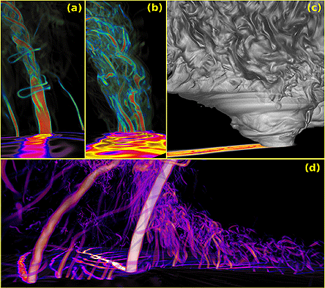
An exceptionally high resolution simulation of a supercell thunderstorm fascinated conferees Tuesday at the AMS 100th Annual Meeting in Boston. Leigh Orf of the University of Wyoming presdented imagery and animations of the simulation that ran on the Blue Waters Supercomputer. With a 10 m grid spanning 11,200 X 11,200 X 2,000 (251 billion) grid volumes, the 270 TB subdomain contains the entire life cycle of the tornado, including 10 minutes prior to tornado formation.
Absolutely mesmerizing quarter-trillion gridpoint resolution tornadic supercell simulations from Dr. Leigh Orf from @UWCIMSS!
Image created with VAPOR3 of a 10-m supercell simulation. (a) Volume rendered cyclonic vertical vorticity, highlighting the 3D structure of the tornado shortly after formation. The 2D surface field traces the maximum surface cyclonic vertical vorticity, providing a representation of the tornado’s path. The view is following the tornado’s path. (b) As in (a), but later in the simulation when the tornado exhibits a multiple vortex structure. (c) Volume rendered cloud mixing ratio, with parameters chosen to present a quasi-photorealistic view of the cloud field. The 2D surface field traces the minimum pressure found in the tornado’s path. (d) As in (a) and (b), but a different, wider view and utilizing different opacity and color map choices. The vortex to the left, which merges with the tornado later in the simulation, is weaker than the nascent tornado as evidenced by the vortex’s more transparent and darker visual presentation and path.
[UPDATED] You’ve heard it before: The convergence of thousands of meteorologists at AMS Annual Meetings brings unusual weather to the host city. Spring-like warmth this weekend in this year’s host city of Boston is continuing this trend.
As of 2 pm ET Sunday, the temperature at Logan International Airport has climbed to at least 73 degrees, breaking the monthly record high of 72 for the city set on January 26, 1950. It smashed the daily record high 61 first established in 1913.
On Saturday, southwest winds gusting to nearly 50 mph drove the day’s high to 70 degrees, topping the daily record set in 1975 by 8 degrees.
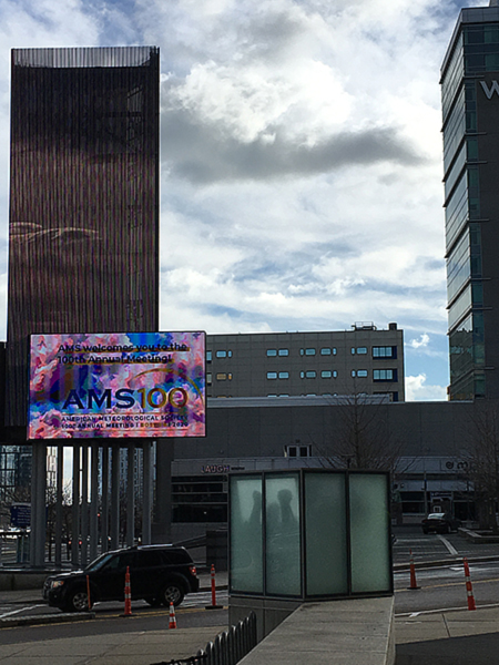
The marquee at the Boston Convention and Exhibition Center announces AMS100. The temperature was a record 69 degrees at the time.
Sunday’s temperature could go even higher—nearby Norwood was 74 at 2 pm—before a a north-south cold front halfway across Massachusetts and Connecticut plows through Boston mid afternoon, bringing an end to the record-setting January thaw. Behind the front blustery northwest winds 40 mph or more will quickly tumble temperatures into the 40s by evening and closer to normal levels overnight and Monday.
We’ve written about the Annual Meeting weather coincidences previously on the AMS blog, dispelling the pervasive myth that our meteorological convergence brings bad and even dangerous weather to the Annual Meeting host city.
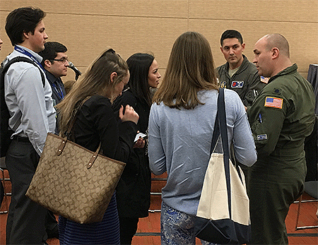
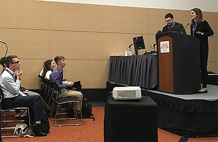
Saturday’s Student Conference at the AMS 100th Annual Meeting kicking off in Boston featured a series of Conversations with Professionals to gain insight into a variety of career choices, the work these professionals in our field currently do, and how they got where they are today. This year’s series, in which short introductions are followed by a Q and A session with students, included two meteorologists who fly into hurricanes with the Air Force 53rd Weather Reconnaissance Wing and another who helps c0-operate the Doppler on Wheels radar for tornado field research.
Below is a sampling of questions students asked Lt. Col. Ryan Rickert and Maj. Jeremy DeHart with the AF Hurricane Hunters as well as Karen Kosiba of the Center for Severe Weather Research. The answers have been edited for length and clarity.
Q (Hurricane Hunters): Can you tell us a little about your backgrounds in the Air Force?
A: (Lt. Col. Ryan Rickert) “Meteorology degrees, with active duty [13 years], go to a weather tech school to learn how to deal with military weather, and then pretty much start with your track—go to a main [Air Force] hub weather regional center to learn how to do big, broad forecasting, then … to a different place and forecast for an airfield so your supporting aircraft at the field. But there are different paths you can take: Science, modeling, Army support, Air Force support, many different ways that you can go.
A: (Maj. Jeremy DeHart) “Yeah, I agree. A lot of people think Air Force, military, and are like ‘Oh, I want to do research … it’s not really my cup of tea.’ but there are so many different tracks you can take, and you’re not going to get the breadth of experience you will in the Air Force doing the jobs we did while on active duty. I have a masters degree and they sent me to California for two years [while on active duty], and I was a full-time student and was paid full-time to go to school. And they’ll do that for your Ph.D., go teach at the Air Force Academy … so don’t be scared off by [military] operations.
Lt. Col. Ryan Rickert (r) and Major Jeremy DeHart at Saturday’s Conversations with Professionals series.
Q (Hurricane Hunters): How do you adjust when a hurricane is rapidly intensifying?
A: (Maj. Jeremy DeHart) You’re always adjusting, because it’s never what you exactly expected. We maintain a pressure altitude of 10,000 feet flying into and through the eye of a hurricane. By the time you’re in the eye, in the stronger storms you’re down to 8,000 feet. In Hurricane Wilma, which set a low pressure record, they were flying at 5,000 feet because they didn’t expect it to be that strong, and by the time they got [in the eye] it had bottomed out and the plane flying a 5,000-foot pressure … was down to about a thousand feet and had to pull up.”
A: (Lt. Col. Ryan Rickert) “We don’t do that anymore. We now go in higher. … When we’re briefing we’re changing things. And even in the execution of the mission we constantly have to adjust. … Constantly changing our pattern if there’s a really intense area [of convection] that doesn’t look [on radar] like it’s safe to go through.
Q (Hurricane Hunters): What do you do in the off-season?
A: (Maj. Jeremy DeHart) “We go to a lot of airshows.”
A: (Lt. Col. Ryan Rickert) “We give talks at conferences, promote what we do, find out what kinds of new instruments we want to put on our airplane, things like that.”
A: (Maj. Jeremy DeHart) “A lot of people don’t realize we have a winter storm requirement as well. … We’ll fly a synoptic pattern and just pepper a big storm with [dropwindsondes]. We’ll fly higher, like 30,000 feet or so, and just carpetbomb the whole thing with instruments.”
Q (Tornado Research): What made you target research versus academia on your career path?
A: (Karen Kosiba) “Sometimes when you’re deep in academia you don’t think there’s anything outside academia. I was getting ready to graduate and I had done tons of field research but also applied for jobs in academia, in government … and I got many of those jobs. So I picked what I liked. But even if you don’t know what you’re doing you visualize that you’ll try a little of everything. … When I first started working with the Doppler on Wheels I thought I was going to be a technician … but I started to enjoy some different things and it just ended up this way. Just because you get a bachelor’s, a master’s, a Ph.D., an associate degree—whatever you’re getting your degree in—doesn’t mean you can’t do different jobs.”
Karen Kosiba, with the Center for Severe Weather Research, answers students’ questions Saturday at the AMS 100th Annual Meeting.
Q (Tornado Research): Can you elaborate a little on graduate school and how you learned how to write grants?
A: (Karen Kosiba) “For those of you in graduate school, or going to graduate school, you usually work with a professor, and they’re trying to get grants, too. My professor said ‘Hey, you want to write a grant proposal?’ and I was like ‘Sure, let’s write a grant proposal.’ And you don’t really know much about how to write them in graduate school. You can just wing it, or you can have a good mentor, like I did. You know, [as an aside] you think your mentor should be someone exactly like you, and even though you can have someone who likes the same stuff as you, it can be advantageous to find a person who can help you meet your career goals. Someone who understands what you want to do and who you want to be.”
Q (Tornado Research): Do you have any advice for recent graduates who are interested in project-based research rather than forecasting? It seems like a lot of people just take the first thing out there, often university helper.
A: (Karen Kosiba) It’s true. But I think there are more opportunities out there than just waking up and taking those first opportunities. In my case not only did I shop for a mentor but also an advisor who could help me out in the field. Big universities often have big field projects, and they don’t always advertise them as well as they should. It can be tricky to get out and get that experience. But places like NCAR have programs getting [their] people out to do field projects. And the University of Wyoming, NSSL, will have projects going in and out. They’re out there and sometimes you have to do a bit of work to find them. Even if one professor doesn’t have anything, they might know someone who just got funded for a project. And once you’re in them take some responsibilities on … and become an active crew member and contributor to the project.