NCAR researcher George Bryan received the 2011 Clarence Leroy Meisinger Award at the 91st AMS Annual Meeting in Seattle for innovative research into the explicit modeling, theory, and observations of convective-scale motions. With this award, the AMS honors promising young or early-career scientists who have demonstrated outstanding ability. “Early career” refers to scientists who are within 10 years of having earned their highest degree or are under 40 years of age when nominated.
The Front Page sought out Dr. Bryan to learn more about the specific problems he is working to solve with his colleagues at NCAR. “We’ve been doing numerical simulations of hurricanes in idealized environments trying to understand what regulates hurricane intensity,” he says. “One of the things we found was that small-scale turbulence is very important, small-scale being less than a kilometer scale—boundary layer eddies in the eyewall, and things like that. And so we’re hoping to take what we learned from that and apply it towards real-time forecasts and real-time numerical model simulations to better improve intensity.” In the interview, available below, Bryan says knowing this will give forecasters a better idea how strong a hurricane is likely to be when one does make landfall.
91stAnnual
Nowhere to Hide from Snow . . . Except Florida
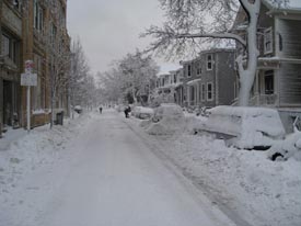
It snowed throughout the Northeast on Wednesday, but very few are feeling sorry for everyone in that region who had to pull out their shovels. The odds are good that you or someone you know in your state has had to deal with snow lately, too–no matter where you live in the country. According to the NWS’s National Operational Hydrologic Remote Sensing Center, which collects snow cover and depth data from ground reports and satellite observations, 49 of the 50 states currently have some snow cover…even Hawaii (this video was taken last month)! Only Florida has avoided a recent visit from Jack Frost.

This isn’t an unprecedented event–in fact, all 50 states had snow on the ground last February 12th, and University of Oklahoma meteorology student and AMS student member Patrick Marsh obtained pictures from every state of that day’s snow.
But “it’s not typical,” says James Peronto, public affairs officer for the NWS, who noted that recent snowfall throughout the Southeast has created the unusually white map.
“The Southern states don’t typically get significant snow amounts through the year,” Peronto said. “It takes a special kind of weather scenario to allow that to happen.”
(This quick history lesson on Southern snow illustrates how rarely such a scenario occurs.)
NWS observations show that 70.9% of the country was covered by snow as of yesterday, compared to an average of 35% snow cover in December.

Snow cover and depth analyses like these are not just for interstate precipitation bragging rights or cabin-fever consolation. At the AMS Annual Meeting in Seattle, a number of science presentations will show the value of snow cover observations.
For example, Patricia de Rosnay et al. will present recent “major changes implemented” in the operational surface analysis of the European Center for Medium-range Weather Forecasting’s Integrated Forecasting System,” including a method of combining satellite observations of snow cover for the land surface conditions for weather modeling. (Tuesday, 25 January, 1:45 p.m.; WSCC 611).
Sujay Kumar et al. (poster 42, 9:45 a.m.-11:15 a.m., Tuesday, 25 January), will discuss snow cover from active microwave remote sensing and look at the value of assimilating snow observations from multiple satellites for hydrological modeling. They point out that “Snow conditions on the land surface are … key components of the global hydrological cycle as they play a critical role in the determination of local and regional climate.”
One way in which this is true is in regions where melted snow dominates water supply. On Thursday 27 January (4:15 p.m., WSCC 611) Randal Koster et al. will “examine how knowledge of mid-winter snow accumulation and soil moisture contributes to our ability to predict streamflow months in advance.” In an experiment with multiple land surface models, “snowpack information by itself contributes, as expected, to skill attained in streamflow prediction, particularly in the mountainous west.” (They go on to show the additional importance of soil moisture conditions to long-lead forecasts, particularly in winter.)
Meanwhile, as a basis for the observations used in such studies, Ding Liang et al. (Poster 595; 8:30 a.m-4 p.m., Wednesday, 26 January) will delve into improvements for modeling of microwave emissivity of snow—an important step toward constructed improved snow cover data retrieved from satellite remote sensing.
New and Just for You: The Young Professionals Reception
The previous post from Annual Meeting Co-Chairs Steve Ackerman and Rajul Pandya talked about some of the new projects and sessions we’re trying out for the first time at the upcoming Annual Meeting. Here’s another that early-career AMS members will find particularly useful and fun: the first ever AMS reception for young professionals sponsored by SAIC on Sunday, 23 January, from 9-11pm in Grand Ballroom D of the Sheraton Hotel (headquarters hotel for the AMS Annual Meeting). You will have the opportunity to meet and network with others who are beginning their careers in the public, private and academic sectors. In addition, there will be opportunities to provide comments and suggestions to the AMS membership committee for how we can better serve our young professional membership.
If you consider yourself an AMS young professional (o.k., all scientists are young forever!) or if you’re trying to find your niche within the AMS community, looking for a job, need career advice; this is the place for you. Or, perhaps you are looking to connect with other AMS young professionals? This is the best opportunity ever at an AMS conference to do just that.
To join our facebook event, click here or search for “AMS Young Professionals Reception” in the events section. For more Information, email Gina Eosco, [email protected], or Ken Carey, [email protected].
Looking Forward to Seattle
by Steve Ackerman and Rajul Pandya, Co-Chairs, 91st AMS Annual Meeting
Happy New Year! Following the communication theme of the 2011 AMS Annual Meeting in Seattle Washington, we thought it appropriate to remind you of some activities that will occur during our annual meeting. There will be some new events this year to accompany the exciting events we have come to appreciate during this meeting – such as Weatherfest and the awards dinner.
This meeting will be the “pilot” effort of the Beacons program. AMS Beacons are folks that will be stationed throughout the conference area to greet and assist you as you participate in this meeting. While there is a special opportunity to meet Beacons at the New Attendee Briefing on Sunday, they will be available throughout the week as well.
For the first time, our annual meeting includes a visual art exhibition hosted by the conference center. The exhibit, Forecast: Communicating Weather and Climate, remains in the conference center through April and is open to the public. The purpose of the exhibit is to engage scientists, artists, and others in cross-disciplinary dialogue on ways to communicate weather and climate issues to the general public. So, roam the halls of the conference center to view and discuss the artworks.
There will be a couple of student activities as well. With help from our vendors, students will make and share measurements of our meeting environment in an activity called, appropriately, “Measuring the Environment”. The Student conference on Saturday will include a game quest, including puzzles to solve and things to find, and the chance to win fantastic prizes.
Finally, the Sunday evening before the conference features two grassroots events: “The Color of Weather”, a gathering celebrating the increasing ethnic and racial diversity of our society, and the “Coriolis” reception for Gay, Lesbian, Bisexual, Transgender and Friends. Both events take place 7:00–9:00 p.m. at the Sheraton Seattle Hotel (1400 Sixth Avenue) “The Color of Weather” in the Willow Room and “Coriolis” in Diamond Rooms A and B.
Look for further updates on posts on this blog, AMS Facebook and Twitter (#91stAMS) feeds.
Snow for Alabama: Can the Models Do the Talking?
Alabama hasn’t had a lot of luck with White Christmases. In Birmingham, for instance, it’s only dusted snow once, and that wasn’t an actual measurable accumulation.
It’s no wonder then that the prospect of snow tomorrow has sent chills of excitement down the spines of Alabamans who have had their eyes glued to the computer models this week.
On his AlabamaWx blog, ABC 33/40 broadcast meteorologist James Spann and Tim Coleman have been trying to temper excessive expectations for days now, even while trying to patiently explain the promising but multifarious model output. On Wednesday, for instance:
There is very little skill in forecasting winter storm events in Alabama until you get with about 48 hours of the event. Nobody knows the exact snow placement and amount this early. Even the know-it-alls don’t know, even though they will never let you bebutlieve it (those of us that have been doing this a long time professionally have had enough doses of humility over the years to be firmly out of the know-it-all camp). We can begin talking accumulation placement tomorrow when that 48 hour window opens up.
and:
The NAM and the GFS, the two primary American models, show very limited moisture, and not much more than a dusting of snow for the I-20 corridor. The deepest moisture will be over the southern half of the state, where initially the precipitation will fall in the form of rain.
The ECMWF and the GEM, the European and Canadian models, are a little more bullish on moisture for North Alabama, but it is still limited. Both of these models suggest enough snow to get 1/2 to 1 inch on the ground. Which, if happens, would be historic for Birmingham. Up north, everybody would completely laugh at the fuss this is creating.
All this talk about what the computers say apparently gets a violently different reaction from folks depending on the stakes. Therein lies a lesson in communicating with science as we approach a meeting devoted to the topic. Wrote one commenter yesterday on AlabamaWx:
Yeah I’m.pretty upset that one.minute the models are right on for a winter storm then the next it flakes out. It literally crushes a lot of peoples wants and all but atleast we did have a chance a day ago! Now its all a good memory.
Just the day before, Spann wrote:
I am amazed at the angry tone of e-mails this evening… some are simply livid that I am not predicting a big Christmas day snow storm that would be historic for Alabama. I will probably never understand why winter weather brings out such passion and emotion. Seems to be more intense every year. Never was like this in the “old days”… one guy called me an “idiot of historic proportion” because “his forecast” was for 6 inches of snow for Birmingham. Wow.
Apparently, despite the cool dispassion of mathematics and computers, it is actually easier for people to rant at computers churning out uncertainty than
Good Things in Small Packages
Don’t let the size of those boxes under the Christmas tree fool you. Good things sometimes come in little packages, and here’s a video from the University of Michigan to prove it.

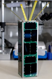
U of M students designed and built a satellite called RAX, or Radio Aurora Explorer, to fit into the standardized 10 cm x 10 cm x 10 cm frames of the CubeSat initiative, which puts low-cost instruments into orbit. Funded by NSF, RAX is a joint venture between the university and SRI International.
Basically the idea is to study plasma instabilities in the ionosphere. These clouds of magnetic disturbance can disrupt communications between Earth and spacecraft. RAX receives and processes signals from incoherent radar based in Alaska that are scattered by these plasma clouds. This makes RAX the NSF’s first space weather satellite. Launched one month ago today, the mission has already dealt with low-power problems with the batteries, but has also proved successful in receiving signals from the radar in Alaska.
The mission is described in this video made before the launch:
You can keep track of RAX on the mission blog, and hear Hasan Bahcivan of SRI present the latest on the mission at the AMS Annual Meeting in Seattle (Tuesday 25 January, 4:45 pm, 4C-3). Also, Richard Behnke of NSF will discuss cubesat and other aspects of the NSF space weather plans (Monday 24 January, 11:45 am, 4C-3).
A New Way to Brighten AMS Meetings
Upon former Executive Director Ken Spengler’s death this summer, Andy White commented in The Front Page, “Ken made me feel like the most important member of the Society. I soon noticed he was that way with everyone.” Added John Lanicci, “The AMS is a lot like a close-knit family, and a much of that credit goes to Ken Spengler for his leadership, and always making you feel welcome, whether you were a newcomer like I was, or a member for 20 or 30 years.”
The AMS Beacons Program, a new initiative of the Membership Committee, is designed to carry on this special legacy of Dr. Spengler’s, fostering the AMS as an open, inclusive, and welcoming organization. The Beacons program is an ambassador program with a “member-staffed goodwill team” reflecting AMS’ initiatives to serve its existing, returning, and potentially new members. AMS Beacons will serve the AMS Executive Director and assist with Society and membership-related functions as deemed necessary or appropriate at AMS annual, specialty, and local chapter meetings and other functions.
The word “beacon” is defined as “a source of light or other signal for guidance; a source of light or inspiration.” This is what the Beacons aim to be for those who participate in the Society’s activities.
The 91st AMS Annual Meeting in Seattle, Washington, will be the “pilot” effort of the Beacons program. Beacons will be a friendly face, providing assistance and help to attendees–from the first time attendee who needs directions, to a regular attendee who might need some timely and thoughtful advice.
Beacons will have a significant presence at the New Attendee Briefing on Sunday, will be stationed at key locations (e.g., registration area, entryways, meetings with large gatherings, etc.), and informally greet and assist as they move throughout the venue during the week. As a volunteer, complementary resource to the AMS staff, Beacons will be trained on what questions and information should be referred to AMS staff members.
Watch for signs at the meeting, and posts on this blog, AMS Facebook and Twitter (#91stAMS) feeds for more about the role of Beacons.
It’s in the Bag
Grocery shoppers usually are prepared to answer just one question at the check out line: “paper or plastic?” In Iowa, though, if they choose paper, they can also answer questions like, “What do you do if you see a tornado?” because they’re likely looking right at the answer….on the sides of the bags filled with their purchases.
The severe weather tips printed on grocery bags are the work of the AMS Iowa State University chapter. It is one of the effective initiatives that recently earned them the AMS Student Chapter of the Year–they’ll be honored along with other 2011 AMS award winners at the upcoming AMS Annual Meeting in Seattle.
The students first provided tips advising what to do in the event of lightning, tornadoes, or flooding, in the Ames and Ankeny HyVee stores in April of last year. Chapter members came up with the idea two years ago as an easy way to increase community weather awareness. They teamed up with the Central Iowa Chapter of the NWA to create the bags and expanded the distribution through much of central Iowa, including the Des Moines metropolitan area.
The chapter plans to expand further this year, aiming to distribute these safety tips to all 220 plus HyVee stores throughout the Midwest, including in Illinois, Iowa, Kansas, Minnesota, Missouri, Nebraska, South Dakota, and Wisconsin.
Roadside Detraction
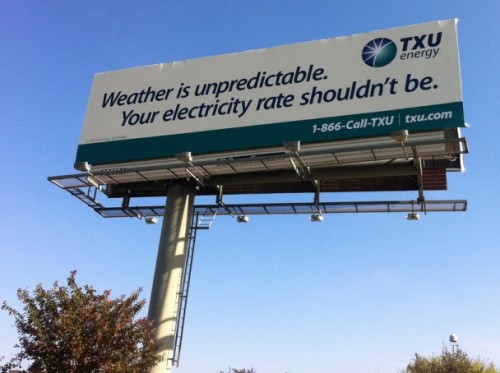
 Broadcast meteorologist Kevin Selle posted this picture to his blog, Digital Meteorologist, with the spot-on comment: “Note to self. Switch energy providers.”
Consider these events from the upcoming AMS Annual Meeting:
- What Do Meteorologists Need to Know about the Energy Sector–and Vice Versa–to Integrate Weather-Driven Renewables into the Electric Grid (Monday 24 January, 7 p.m., Town Hall meeting)
- Dollars and Cents: Weather for Energy Markets and Weather Fundamentals for Energy Planning (Thursday 27 January sessions of the Conference on Weather Climate and the New Energy Economy).
Meanwhile the atmospheric science community moves on, working to make lives easier and more stable for utilities and their customers. For instance, Erica Zell will be presenting “NASA Products to Enhance Energy Utility Load Forecasting” (Wednesday, 26 January) in Seattle. She notes:
Existing load forecasting tools rely upon historical load and weather, and forecasted weather to predict load within energy utility service areas. Microclimates and weather events such as stalled fronts have proved particularly challenging for load forecasting. The shortcomings of load forecasts are often the result of weather data that is not at a fine enough spatial resolution to capture local-scale weather events.
Zell offers hope by integrating high resolution satellite-derived atmospheric information into load forecast tools.
We could go on, of course.
Energy provider driving down Texas highway mutters: “Note to self. Switch energy providers!”
A Good Climate for Looking at Clouds
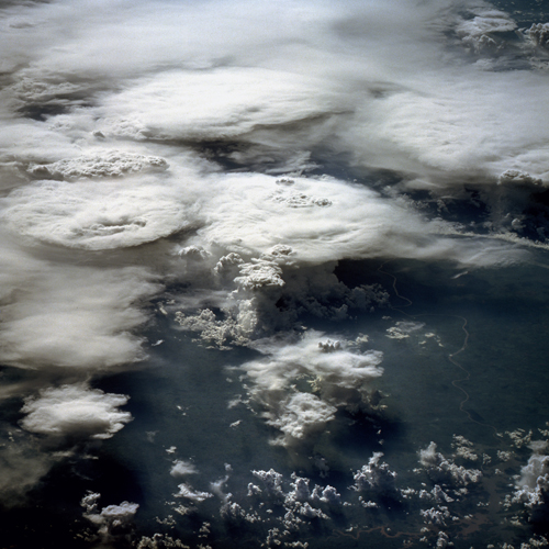
How much do we know about clouds and the effects they have on climate change? It’s a lingering source of uncertainty, with as many questions as answers. No wonder the National Science Foundation calls them “The Wild Card of Climate Change” on its new website about the effect of clouds in climate.
The site is good place to start thinking about this complicated issue. The NSF page features videos of cloud experts like David Randall of Colorado State University and AMS President Peggy LeMone of NCAR, as well as a slide show, animations, articles, and other educational material that address some of most salient cloud/climate questions, such as: Will clouds help speed or slow climate change? Why is cloud behavior so difficult to predict? And how are scientists learning to project the behavior of clouds?
The impression one gets from the website about the progress of the science in this area may vary depending on your point of view, but Randall, for one, sounds about as optimistic as you can get. In his video, he admits that optimism is a job requirement for climate modelers, but in his assessment, “We’re not in the infant stages of understanding [clouds] any more; we’re in first or second grade, and on the way to adolescence.” His hope for solving their role in climate and representing cloud effects in climate modeling rests in part on better computers and in part on the numerous bright people entering the field now, ready to overshadow the work of their mentors.
The AMS Annual Meeting in Seattle will be a good occasion to dig deeper at the roots of Randall’s optimism and sample some of the emerging solutions to the cloud/climate relationship. For example, Andrei Sokolov and Erwan Monier of MIT will discuss the influence that adjusting cloud feedback has on climate sensitivity (Wednesday, 26 January, 11:30 a.m. in Climate Variability and Change). Basically, they’re using small adjustments to the cloud cover used to calculate surface radiation in a model to create a suite of results–an ensemble. The range of results better reflects the sensitivity of climate observed in the 20th century better than some other methods of creating ensembles, such as adjusting the model physics.
Randall says in his video that early predictions about climate change are already coming to pass and this leads to optimism that more predictions will verify well in the coming years as we scrutinize climate more and more closely. This of course presupposes sustained efforts to observe and verify. Laying the groundwork for this task–and for thus better climate models–are Stuart Evans (University of Washington) and colleagues in a study they are presenting in Seattle. According to their abstract, “Improving cloud parameterizations in large scale models hinges on understanding the statistical connection between large scale dynamics and the cloud fields they produce.” Their study focuses on the relationship between synoptic-scale dynamic patterns and cloud properties (Monday, 24 January, 11 a.m. in Climate Variability and Change). Evans et al. dig through 13 years of cloud vertical radar profiles from the US Southern Plains site of the DOE ARM program and relate it to atmospheric “states”, thus providing a metric for evaluating how well climate models relate cloudiness to radiation and other surface properties.
While Evans and colleagues use upward looking remote sensing, Joao Teixeira (JPL/Cal Tech) and coauthors look down at boundary layer cloudiness from above–using satellites. They expect to show how new methodologies with satellite data can improve the way low level clouds are parameterized in climate models (Thursday, 27 January, 9:30 a.m., in Climate Variability and Change). A recent workshop at Cal Tech on space-based studies of this problem stated:
Clouds in the boundary layer, the lowermost region of the atmosphere adjacent to the Earth’s surface, are known to play the key role in climate feedbacks that lead to these large uncertainties. Yet current climate models remain far from realistically representing the cloudy boundary layer, as they are limited by the inability to adequately represent the small-scale physical processes associated with turbulence, convection and clouds.
The lack of realism of the models at this low level is compounded by the lack of global observing of what goes on underneath the critical low-level cloud cover–hence the effort of Teixeira et al. (and others) to “leverage” satellite observing, with its global reach, to improve understanding of low level thermodynamics in the name of improving climate simulations.
