Cruising the Ocean’s Surface Microlayer

Oceans are deep, and they are integral to the climate system. But the exchanges between ocean and atmosphere that preoccupy many scientists are not in the depths but instead in the shallowest of shallow layers.
A lot happens in the topmost millimeter of the ocean, a film of liquid called the “sea-surface microlayer that is, in many ways, a distinct realm. At this scale, exchanges with the atmosphere are more about diffusion, conduction, and viscosity than turbulence. But the layer is small and difficult to observe undisturbed and over sufficient areas. As a result, “it has been widely ignored in the past,” according to a new paper by Mariana Ribas-Ribas and colleagues in the Journal of Atmospheric and Oceanic Technology.
Nonetheless, Ribas-Ribas and her team, based in Germany, looked for a new way to skim across and sample the critical top 100 micrometers (one tenth of a millimeter) of the ocean. This surface microlayer (SML) “plays a central role in a range of global biogeochemical and climate-related processes.” However, Ribas-Ribas et al. add,

The SML often has remained in a distinct research niche, primarily because it was thought that it did not exist in typical oceanic conditions; furthermore, it is challenging to collect representative SML samples under natural conditions.

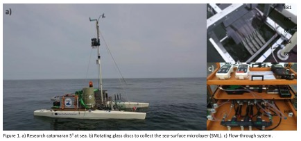
In their paper (now in early online release), the authors report on their solution to observing is a newly outfitted remote-controlled catamaran. A set of rotating glass discs with holes scoops up water samples. Pictured below are the catamaran and (at left, top) the glass discs mounted between the hulls and (bottom left) the flow-through system.
catamaran
Catamarans are not new to this research, but they were generally towed behind other vessels and subject to wake effects or were specialized. The new Sea Surface Scanner (S3) takes advantage of better remote control and power supply technology and can pack multiple sampling and sensors and controls onto one platform. Tests in the Baltic Sea last year showed the ability of S3 to track responses of organisms in the surface microlayer to ocean fronts, upwelling areas, and rainfall. The biological processes in turn affect critical geochemical processes like exchanges of gases and production of aerosols for the atmosphere.
The technology may be a fresh start for research looking in depth at the shallowest of layers. See the journal article for more details on the S3 and its performance in field tests.
 

Withdrawal from the Paris Agreement Flouts the Climate Risks

by Keith Seitter, AMS Executive Director
President Trump’s speech announcing the U.S. withdrawal from the Paris Climate Agreement emphasizes his assessment of the domestic economic risks of making commitments to climate action. In doing so the President plainly ignores so many other components of the risk calculus that went into the treaty in the first place.
There are, of course, political risks, such as damaging our nation’s diplomatic prestige and relinquishing the benefits of leadership in global economic, environmental, or security matters. But from a scientific viewpoint, it is particularly troubling that the President’s claims cast aside the extensively studied domestic and global economic, health, and ecological risks of inaction on climate change.
President Trump put it quite bluntly: “We will see if we can make a deal that’s fair. And if we can, that’s great. And if we can’t, that’s fine.”
The science emphatically tells us that it is not fine if we can’t. The American Meteorological Society Statement on Climate Change warns that it is “imperative that society respond to a changing climate.” National policies are not enough — the Statement clearly endorses international action to ensure adaptation to, and mitigation of, the ongoing, predominately human-caused change in climate.
In his speech, the President made a clear promise “… to be the cleanest and most environmentally friendly country on Earth … to have the cleanest air … to have the cleanest water.” AMS members have worked long and hard to enable such conditions both in our country and throughout the world. We are ready to provide the scientific expertise the nation will need to realize these goals. AMS members are equally ready to provide the scientific foundation for this nation to thrive as a leader in renewable energy technology and production, as well as to prepare for, respond to, and recover from nature’s most dangerous storms, floods, droughts, and other hazards.
Environmental aspirations, however, that call on some essential scientific capabilities but ignore others are inevitably misguided. AMS members have been instrumental in producing the sound body of scientific evidence that helps characterize the risks of unchecked climate change. The range of possibilities for future climate—built upon study after study—led the AMS Statement to conclude, “Prudence dictates extreme care in accounting for our relationship with the only planet known to be capable of sustaining human life.”
This is the science-based risk calculus upon which our nation’s climate change policy should be based. It is a far more realistic, informative, and actionable perspective than the narrow accounting the President provided in the Rose Garden. It is the science that the President abandoned in his deeply troubling decision.

Atlantic Hurricane Season Begins

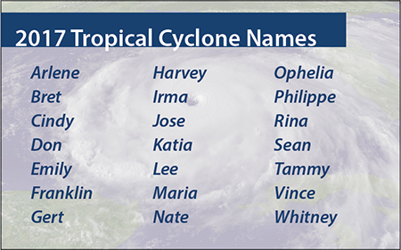
2017 Atlantic hurricane season namesThe 2017 Atlantic hurricane season has begun. If they haven’t already, people who could be affected by tropical storms and hurricanes should prepare now for the six-month season, which ends November 30 and encompasses the Atlantic Ocean, Caribbean Sea, and Gulf of Mexico.
Here’s what you need to know. Follow the links for more detailed information:
What’s New
Two new products this year will be issued by the National Hurricane Center in addition to the typical tropical storm and hurricane watches, warnings, and advisories:

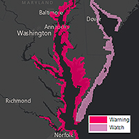
  • Storm surge watches & warningsStorm surge watches will be issued within 48 hours of possible life-threatening coastal inundation. Storm surge warnings will be issued at least 36 hours before the danger of life-threatening coastal inundation is realized. The new graphical products will be issued in tandem with NHC’s Potential Storm Surge Flooding Map, which quantifies the expected inundation from storm surge and indicates the depth of the flooding on land.
  • Potential tropical storms and hurricanes growing out of disturbances that have not yet become tropical depressions or storms but that pose the threat of bringing tropical storm or hurricane conditions to land areas in 48 hours will be treated as regular storms, with NHC issuing watches, warnings, advisories, and related graphical products as needed.
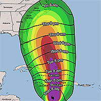
  • Arrival of tropical storm windsAdditionally, NHC will introduce a map to provide guidance on when users should have their preparations completed before a storm. These experimental graphics will show Time of Arrival of Tropical-Storm-Force Winds—a critical planning threshold for coastal communities. Many preparations become difficult or dangerous once tropical storm conditions begin.

Prepare
People living in states bordering the Atlantic Ocean and Gulf of Mexico, as well as in The Bahamas, Bermuda, and Caribbean islands, should know that water could be a life-threatening hazard when a hurricane hits. This threat includes storm surge—the sudden rise of seawater at the coast near and to the right of where a hurricane’s center makes landfall. In the United States, hurricane evacuation maps account for the flooding from storm surge and show areas along the coast that people should evacuate if a hurricane threatens. Or it could be from freshwater flooding triggered by a storm’s torrential rain. If either is a risk, make a plan now to leave when threatened.
If water is not a risk, and your area will only face the threat of strong, damaging winds, the official recommendation from the National Hurricane Center is to shelter in place. Meaning, stay put—rather than evacuate. But stay only if your residence is sufficient to weather the storm. Now is the time to prepare your home and property for the possibility of high winds and heavy rain.
Forecasts
A wide variety of academics, private forecasting companies, and the U.S. government issue seasonal hurricane predictions. They generally tend to agree, particularly when a season is expected to be well above or below average. But this year could be a bit different with some predicting fewer tropical storms and hurricanes than is typical in an average year, and others predicting more than the usual numbers of storms and hurricanes. An average Atlantic hurricane season sees a dozen named storms, with a half-dozen of these becoming hurricanes and two going on to become major hurricanes with sustained winds greater than 110 mph.
A quick look at the five longest-running seasonal forecasts for named storms, hurricanes, and major hurricanes, respectively:

The reason for the low numbers in those forecasts with ranges: there’s uncertainty about whether another El Niño may form midway though the season—El Niño is an anomalous warming of the eastern tropical Pacific that causes air to rise and spread out there, creating wind shear over the Atlantic that inhibits tropical development—as well as whether warmer-than-usual sea surface temperatures in the tropical Atlantic favorable for development will remain that way or cool through the season. Increasing numbers in several forecasts updated since earlier in the spring seem to indicate a lower likelihood of both, although forecasters caution they could reduce the numbers if more than a weak El Niño develops and Atlantic SSTs consequently cool.
Bottom Line
Nearly every weather entity states what Acting FEMA Administrator Robert J. Fenton, Jr. recently expressed after NOAA released its hurricane season forecast last week: “Regardless of how many storms develop this year, it only takes one to disrupt our lives.”
The advice of hurricane forecasters and emergency managers alike is to prepare early and as if this will be the year your neighborhood is hit.
Storm Names
If this year’s list of names the National Hurricane Center will use to keep track of Atlantic storms seems familiar, it’s because it is. NHC made it all the way through this list in the 2005 season. The names of five memorable and deadly hurricanes that year were retired: Dennis, Katrina, Rita, Stan, and Wilma. The updated list was used again in 2011, since NHC rotates through six sets of names, and Irene that year also was retired and replaced.

When Art Is a Matter of (Scientific) Interpretation

We’ve seen plenty of examples of scientists inspiring art at AMS conferences. It is also true that art can inspire scientists, as in the kick-off press conference at this week’s European Geophysical Union General Assembly in Vienna, Austria.
The_ScreamA team of scientists came forward with a new hypothesis about the origins of one of the icons of Western art–Edvard Munch’s The Scream. Since 1892, the man melting down on a bridge under a wavy, blood-red Oslo sunset has been a pillar of the modern age precisely because it expresses interior mentality more than objective observation. Or so art history tells us.
To be fair, some art historians also have made clear that there are honest clouds in Munch’s painting. In a 1973 monograph, the University of Chicago’s Reinhold Heller acknowledged Munch’s “faithfulness to meteorological and topographical phenomena” in a precursor canvas, called Despair. Even so, Heller went on to say that Munch’s vision conveyed “truthfulness solely in its reflection of the man’s mood.”
Take a Khan Academy course on the history of art and you’ll learn that Munch was experiencing synesthesia—“a visual depiction of sound and emotion….The Scream is a work of remembered sensation rather than perceived reality.”
Leave it to physical scientists, then, to remind us that nature, as an inspiration for artists, is far stranger than art historians imagine. Indeed, faced with The Scream, scientists have been acting just like scientists: iterating through hypotheses about what the painting really shows.
In a 2004 article in Sky and Telescope magazine, Russell Doescher, Donald Olson, and Marilynn Olson argued that Munch’s vision was inspired by sunsets inked red after the eruption of Krakatau in 1882.
More recently, atmospheric scientists have debunked the volcanic hypothesis and posited alternatives centered on specific clouds. In his 2014 book on the meteorological history of art, The Soul of All Scenery, Stanley David Gedzelman points out that the mountains around Oslo could induce sinuous, icy wave clouds with lingering tint after sunset. The result would be brilliant undulations very much like those in the painting.
At EGU this week, Svein Fikke, Jón Egill Kristjánsson, and Øyvind Nordli contend that Munch was depicting much rarer phenomenon: nacreous, or “mother of pearl,” clouds in the lower stratosphere. They make their case not only at the conference this week, but also in an article just published in the U.K. Royal Meteorological Society’s magazine, Weather.
Munch never revealed exactly when he saw the sunset that startled him. As a result, neither cloud hypothesis is going to be confirmed definitively.
Indeed, to a certain extent, both cloud hypotheses rest instead on a matter of interpretation about the timing of the painting amongst Munch’s works, about his diary, and other eyewitness accounts.
The meteorology, in turn, is pretty clear: The Scream can no longer be seen as solely a matter of artistic interpretation.
 

Monster Felix Slammed Hurricane Hunter Plane in 2007

A one-two punch inside intense Hurricane Felix in 2007 turned a NOAA hurricane hunter flight into a harrowing rollercoaster ride, causing the mission to be aborted. A study of the extreme event, scheduled for publication in the next issue of Monthly Weather Review, determined a small-scale vortex known as a misocyclone rotating within the Category 5 hurricane’s eyewall is likely what bucked the plane upward nearly a thousand feet before sending it plunging back to its original altitude in less than a minute. The feature is similar to what nearly crashed the same plane inside Hurricane Hugo in 1989.
According to the study, a “routine penetration” into the eye of the hurricane via the northeast eyewall on September 2, 2007 quickly became anything but. First, the horizontal wind speed at the plane’s altitude of about 10,000 feet jumped from 140 mph to nearly 200 mph. At the same time, a standard descent into the eye at a constant 700 mb pressure height quickly steepened and the plane lost more than 700 feet in altitude in 40 seconds. Then a 70 mph updraft punched the plane up 900 feet immediately followed by a 16 mph downdraft that hammered the plane downward 980 feet, in seconds. The on-board radar quit. And gravitational stresses on the aircraft exceeded safety specifications. The mission was scrubbed and the plane then settled into Felix’s calm 12-mile-wide eye at about 8900 feet, circling five times until it could find a safe pass through the southwest eyewall and out of the hurricane.
They were lucky.
The hurricane hunters have unknowingly flown into these updraft-downdraft combinations before. They seem to only encounter them in monster Category 5 hurricanes, which have sustained winds greater than 156 mph. Besides Felix, researchers have documented the extreme events in Hurricanes Patricia (2015), Isabel (2003), and Hugo (1989). The encounter in Hurricane Hugo took place with the same hurricane hunter plane (NOAA42) flying at just 1500 feet, which was typical back then. Not any more. Fists of wind smashed the aircraft downward more than a thousand feet and then back upward, knocking out three of the its four turboprop engines and crippling the plane. It barely made it out, and afterward the rules for hurricane eye penetrations were rewritten.
Back it 1989, researchers thought they had perhaps flown into a tornado in the eyewall. But in Hurricane Isabel, data revealed a vortex a bit larger but no less intense was encountered. Similar in scope but smaller in size to the rotating 5-10-mile-wide updrafts of supercell thunderstorms, which have become known as mesocyclones, the hurricane eyewall vortexes were only a fraction of that—hence the name misocyclones, or small-scale cyclones.
In Felix, a bit of serendipity: just as the plane encountered the misocyclone, researchers released a commonly used tube of instruments called a dropwindsonde into the eyewall to measure temperature, pressure, humidity, and with onboard GPS tracking, wind speed and direction. The dropwindsonde measured details of the wind within the misocyclone, including a shift in the horizontal direction and a speed that jumped to more than 230 mph at about 400 feet decreasing to just 41 mph near the water. The tremendous shear—change in the wind speed in such a short distance—is “8 orders of magnitude larger than those known to lead to […] horizontal shearing instabilities and misocyclone development,” the study noted based on prior research.
It’s only the second time details of a misocyclone have been measured, making them largely mysterious events. For example, researchers aren’t certain how common or unusual they are. “Many very intense tropical cyclones have been sampled with aircraft without encountering these extreme events,” the study states, adding, “It is unknown whether they have been missed by the relatively sparse observations available, because aircraft tend to deviate around the most intense eyewall convection, or if they are truly rare.”
Deepening the mystery is the timing of the extreme event inside Felix—it occurred as with Hugo at the end of a period of rapid intensification, which is when a hurricane’s central pressure drops precipitously ramping up its sustained winds very quickly. Winds in Hurricane Felix increased by 90 mph to 165 mph sustained that day in 2007. It has been thought that extreme features in hurricanes such as lightning, graupel, and eyewall vortices likely occur during periods of rapid intensification, as occurred with Hurricanes Isabel and Patricia. But Felix is the second intense hurricane where such an extreme event took place at the end of a rapid intensity cycle, and learning why while keeping the hurricane hunters safe will require further study.
“The frequency of these features and their ultimate importance in the structural evolution [of hurricanes] remain research questions. It is clear, though, that improved understanding of these features would enhance the safety of flights into very intense tropical cyclones.”
Washington Forum to Explore Working with the New Administration

by Keith Seitter, AMS Executive Director
The AMS Washington Forum, held each spring, is organized by the Board on Enterprise Economic Development within the Commission on the Weather, Water, and Climate Enterprise. It brings together leaders from the public, private, and academic sectors for productive dialogue on issues of relevance to the weather, water, and climate enterprise in this country. Compared to our scientific conferences, it is a small meeting with typically a little more than 100 participants. This allows for a meeting dominated by rich discussion rather than presentations. The Forum takes advantage of being held in Washington, D.C., with panel discussions featuring congressional and executive branch staff, as well as agency leadership. It is no secret that this is one of my favorite meetings of the year, and for many in the atmospheric and related sciences community, the Washington Forum has become a “can’t miss” event on their calendar.
The 2017 Washington Forum will be held May 2–4, 2017 at the AAAS Building, 1200 New York Avenue, Washington, DC. (Note that this year’s Forum occurs later in the year than usual.) The organizing committee has put together an outstanding program again this year under the timely, and perhaps provocative, theme: “Evolving Our Enterprise: Working Together with the New Administration in a New Collaborative Era.” The transition to a new administration is bringing changes in department and agency leadership that directly impact our community. The Forum will provide a terrific opportunity to explore how the community can collaboratively navigate these changes in ways to ensure continued advancement of the science and services for the benefit of the nation. I am expecting three days of very lively discussion.
We have a special treat this year in conjunction with the Forum. On the afternoon before the Forum formally begins, Monday, May 1, the Forum location at the AAAS Building will host the second Annual Dr. James R. Mahoney Memorial Lecture. The lecture honors the legacy of Mahoney (1938–2015), AMS past-president and a leader in the environmental field in both the public and private sectors, having worked with more than 50 nations and served as NOAA Deputy Administrator in addition to other key government posts. The Mahoney Lecture is cosponsored by AMS and NOAA, and the annual lecture is presented by a person of stature in the field who can address a key environmental science and/or policy issue of the day. We are very pleased to announce that Richard H. Moss, senior scientist at Pacific Northwest National Laboratory’s Joint Global Change Research Institute and adjunct professor in the Department of Geographical Sciences at the University of Maryland, College Park, will deliver the second Mahoney Lecture. The lecture will begin at 4:00 p.m. and will be followed by a reception. The lecture is free and does not require registration to attend.
If you have ever thought about attending the Washington Forum but have not yet done so, this would be a great year to give it a try. We do limit attendance because of space constraints and the desire for this meeting to have a lot of audience participation and discussion, so I would encourage you to register early. You can learn more about the Forum, and register to attend, at the Forum website.
(Note: This letter also appears in the March 2017 issue of BAMS.)

Field Tests for the New GOES-16

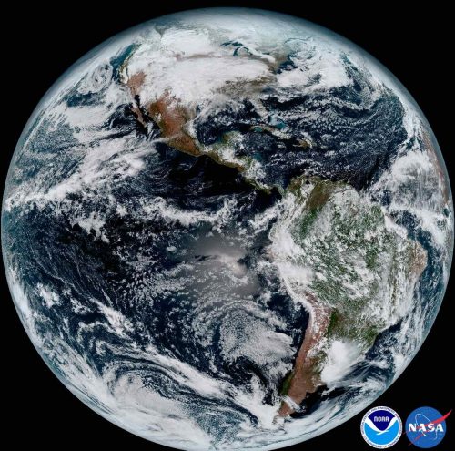
“Who ever gets tired of looking at this thing?” asked Steve Goodman of an appreciative audience when he presented a slide of the new imagery from GOES-16 at the 97th AMS Annual Meeting this January.
abi_full_disk_low_res_jan_15_2017
The answer was clearly, “Nobody.”
The images from GOES-16 have been dazzling, but the hard work of maximizing use of the satellite is ongoing, especially for Goodman’s agency, the National Environmental Satellite, Data, and Information Service (NESDIS).
The successful launch in November was a major step for the weather community. Compared to the older geostationary satellites, the new technology aboard GOES-16 offers a huge boost in the information influx: 3x improvements in spectral observing, a 4x spatial resolution advantage, and 5x temporal sampling upgrades. But new capabilities mean new questions to ask and tests to perform.
The satellite is barely up in space and already NOAA is targeting its performance for a major scientific study. Last week was the official start of a three-month study by NESDIS to “fine-tune” the data flowing from our new eye in space.
You can learn more about the GOES-16 Field Campaign in the presentation that Goodman gave at the Annual Meeting. He pointed out that it has been 22 years since the imager was updated, and that the satellite also includes the Global Lightning Mapper (GLM), which is completely new to space.
“We thought it would be good, getting out of the gate, to collect the best validation data that we can,” Goodman said.
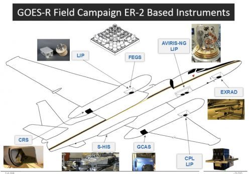
er2Over a period of 6 weeks, the NASA ER-2 high-altitude jet will fly 100 hours in support of the studies. The flights will be based first from California and then in Georgia, well-timed to coordinate with the tornado field campaign, VORTEX-SE. All the while, the airplane’s downward-looking sensors need to be aimed to match the angle of observation of the satellite-borne sensors. The ER-2 will fly its specially built optical simulator that mimics the GLM.
“That’ll give us optical to optical comparisons,” Goodman noted.
To further check out GLM’s performance, there will also be underpasses from the International Space Station, which now has a TRMM-style lightning detector of its own. “That’s a well-calibrated instrument—we know its performance,” Goodman added.
Meanwhile lower-orbit satellites will gather data from “coincident overpasses” to coordinate with the planes, drones, and ground-based observing systems.
Such field campaigns are a routine follow-up to satellite launches. “Field campaigns are essential for collecting the reference data that can be directly related to satellite observations,” Goodman. He raises a number of examples of uncertainties that can now be cleared up. For example, some flights will pass over Chesapeake Bay, which provides a necessary “dark” watery background: “We didn’t know how stable the satellite platform would be, so there’s concern about jitter for the GLM…so we want to know what happens looking at a bright cloud versus a very dark target in side-by-side pixels.”
Goodman said tests of the new ABI, or Advanced Baseline Imager, involve checking the mirror mechanism that enables north-south scanning. For validation, the project will position a team of students with handheld radiometers in the desert Southwest, but also do a first-time deployment of a radiometer aboard a unmanned aerial system.
The expected capabilities of the ABI, with its 16 spectral channels, are featured in an article by Timothy Schmit and colleagues in the April issue of the Bulletin of the American Meteorological Society.

Thanksgiving in March

by Keith Seitter, AMS Executive Director
The past few months have been a period of increased anxiety for many of us in the weather, water, and climate community as we contemplate how changes in the nation’s administration will impact agencies and programs, and, ultimately, how well our science and the services based on it can move forward. Despite the fact that we work in disciplines that routinely deal with uncertainty, it is not easy for us to deal with the particular flavor of uncertainty we have been facing, or to keep it from being deeply unsettling.
At AMS, we have focused on being even more vigilant in working to defend the integrity of the scientific process and in trying to ensure that the best peer-reviewed science is brought to bear on issues facing our country and the world. Recognizing the importance of those efforts—and even with occasional successes in them—does not keep one from becoming disheartened in dealing with our “post-fact world.”
I was feeling particularly discouraged recently as all this weighed on me, and then I realized that what I should be doing is creating the kind of list many of us do on Thanksgiving. Here it is:

  • I’m thankful to be part of a community whose work really matters. And that people become part of this community because they know how much this work matters and they bring dedication and passion to it every day.
  • I’m thankful that the general public appreciates and depends on the work of our community. They look to us every day to help them make decisions both big and small, and put their trust in us to keep them out of harm’s way (even though they may, at times, complain about our efforts).
  • I’m thankful that we can—and do—rely on a scientific process to discern how our environment works so that we can speak with confidence. It is not what we believe, but what we can observe, measure, and objectively model based on known physics that guides us.
  • I’m thankful I work at an organization guided by a Council made up of gifted and dedicated volunteer leaders, and that I can spend my time working with an incredible professional staff.

By the time I got to the end of this list, I was no longer feeling discouraged but, instead, was energized and ready to keep working toward making sure that the best available scientific knowledge and understanding was getting into the hands of policymakers at all levels. We may be in the midst of particularly challenging times, but AMS, as a very highly respected “honest broker” covering the science and services of the weather, water, and climate community, is in a position to be particularly effective in working through those challenges.
(A version of this post appeared in AMS Executive Director Keith Seitter’s “Letter from Headquarters” column in the February 2017 BAMS.)

Great bursting balloons, Batman!

Ever wonder what happens to weather balloons as they reach their peak altitude and can’t take the low pressure anymore? They pop, right? Nope. They shatter! Shred! Explode!
This video shows the unique way a weather balloon bursts at about 30,000 m.

Credit: Patrick Cullis (NOAA/CIRES)
The full explanation and several stills to show the explosion in spectacular “stop-action” are in an upcoming issue of BAMS. For members, the BAMS digital edition with its new multimedia capabilities will show the article with both the stills and an embedded video.

A Scientific Neighborhood

At some point, very early in our meteorological education, we learn that the atmosphere, the oceans—and thus weather and climate everywhere—are inextricably linked across the globe. Your weather is my weather, no matter where you live and where I live.
Weather makes us all neighbors—partners in science across vast distances. The idea is indelibly etched in our science. It was alive as early as Benjamin Franklin, writing to his brother hundreds of miles away to ask if the weather in Boston bore any relation to the weather in Philadelphia. It pervades the insights of Edward Lorenz, who taught that the flap of a butterfly’s wings in Brazil might be the trigger for a tornado in Texas.
The neighbor principle of weather drives discovery and propels the dramatic improvement in forecasting and understanding we continue to witness. We see this ethos in the free exchange of data and sharing of resources to build our Global Observing System. We see it when Europeans and Japanese move their satellites to help us cover gaps in our observing, and when Americans do the same for them. In science and saving lives, we are neighbors, across thousands of miles of ocean.
The good neighbor spirit was alive and well at an AMS Annual Meeting Town Hall on U.S.-International Partnerships this month. The panel featured representatives from AMS, the World Meteorological Organization, and the meteorological societies of China, Japan, South Korea—people who traveled half a world from their families to be with us. They came together to tout the value of close international collaborations. At the Town Hall, it was clear why scientists seek opportunities to confer with each other, across borders. “We need to learn from each other,” the panelists agreed.
Last week the AMS joined 170 other professional, academic, and scientific organizations in signing a letter to President Trump. The letter warned that the Executive Order issued on January 27 regarding visas and immigration has “profound implications for diplomatic, humanitarian, and national security interests, in part because of the negative impact on U.S. science and engineering capacity.”
The letter points out that

In order to remain the world leader in advancing scientific knowledge and innovations, the U.S. science and technology enterprise must continue to capitalize on the international and multi-cultural environment within which it operates.

AMS has been doing more and more to recognize the reality of that international and multi-cultural environment in our disciplines. This reality has a long history. Franklin’s ideas on lightning were quickly celebrated in Europe, for example. And the founder of modern weather services in our country, Cleveland Abbe, encouraged translations of seminal European papers in the pages of Monthly Weather Review, a journal he founded in 1872 to make domestic meteorologists aware of relevant scientific innovations. Throughout the early 20th century revolution of scientific weather forecasting, major advances came through exchanges of scientists traveling to Europe, and from Europeans scientists who came to the United States. Nearly every American in the AMS can trace their personal scientific “lineage” to trans-Atlantic and trans-Pacific exchanges of this kind.
Today, AMS continues this neighborliness of science—through cooperative agreements with societies in Canada, China, Europe, and India and elsewhere, through the programming of its meetings, and through the pages of its widely read journals. Take the latest Annual Meeting: more than 500 attendees came from outside the United States. Look at the latest issue of AMS’s Journal of Climate: fully half of the 50 authors listed there are affiliated with institutions of other countries. A large number of the other half were educated, at least in part, in overseas institutions. Scientific talent, innovative ideas, professional heritage—all flow across the globe as necessarily as wind and water.
This international environment is the scientific neighborhood in which we live. It is one critical reason that AMS and its cosigners offered the President their assistance in “crafting an immigration and visa policy that ensures strong borders while staying true to foundational American principles as a nation of immigrants.”