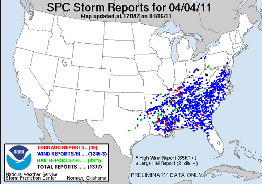
A storm system that stretched from the Mississippi River to the mid-Atlantic states on Monday brought more than 1,300 reports of severe weather in a 24-hour period, including 43 tornado events.
The extraordinary number of reports testifies to the intensity of the storm, which has been blamed for at least nine deaths, but it also reflects changes in the way severe weather is reported to–and recorded by–the Storm Prediction Center. As pointed out by Accuweather’s Brian Edwards, the SPC recently removed filters that previously prevented multiple reports of the same event that occurred within 15 miles of each other. Essentially, all reports are now accepted, regardless of their proximity to other reports. Additionally, with ever-improving technology, there are almost certainly more people sending reports from more locations than ever before (and this is especially true in highly populated areas such as much of the area covered by this storm).
So while the intensity of the storm may not set any records, the reporting of it is one for the books. According to the SPC’s Greg Carbin, Monday’s event was one of the three most reported storms on record, rivaled only by events on May 30, 2004 and April 2, 2006.
Weather Systems
Special Session Today on the 2010 Icelandic Volcano Eruptions
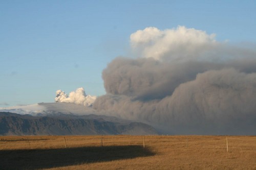
The Eyjafjallajökull volcano eruption in Iceland lasted from the 15 April to 25 May 2010. In addition to threatening local people and their livestock, the volcano sent an ash plume to heights of up to 26,000 feet. Due to the weather conditions, the plume spread over a large part of Europe. Because volcanic ash can cause airplane engines to fail, the plume disrupted aviation over several weeks.
Weather Services played a key role in predicting the spread of the ash and advising the aviation industry. The forecasts were based on safety thresholds for flying through volcanic ash set by the International Civil Aviation Organisation (ICAO) along with the national aviation authorities and aircraft manufacturers.
Scientists modelled the evolution of the ash cloud using dispersion models and trajectory models. The model predictions were compared with observations from satellites, aircraft and ground-based networks.
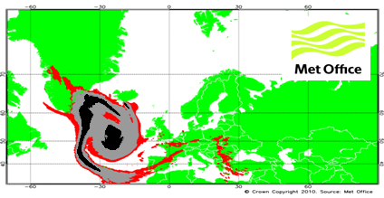
The eruption of Eyjafjallajökull presented challenges to the meteorological community, especially in Europe. The event highlighted the importance of enhanced international coordination to ensure a consistency of approach in the observation, forecasting and dissemination of volcanic ash information and warnings.
At the AMS annual meeting, papers covering the observing, forecasting and warning to the public and especially to the airline industry regarding the effects of the eruption of Eyjafjallajökull will be presented today (Monday) at the Special International Applications Session 1B: The Eyjafjallajökull Volcanic Eruption of 2010 (1:30 pm). At 2 pm Ian Lisk of the UK Met Office talks about how the aviation industry, grounded by safety rules, put pressure on meteorologists to produce ash concentration charts to supplement the normal information from the Volcanic Ash Advisory Centre in the UK. This was an added burden on dispersion modeling services (with the NAME model), but the results proved promising:
The largest uncertainty in the computer modelling of ash dispersion and transport is the ability to accurately reflect the status of the eruption at model initialization. This is less of a modelling issue and much more a case of being able to accurately and safely observe what the volcano is doing in real time, in particular, the:
•Height, diameter and time variance of eruptive column;
•Assessment of ash concentration and particle size/distribution;
•Ash deposition close to the volcano i.e. ash that is not available to be transported.
Unlike atmospheric phenomena, volcanic eruptions are in fixed places and don’t condense or disappear out of thin air, like atmospheric phenomena…but apparently observing them isn’t much easier.
The Unconventional Convention–A 'Curse' Put to Rest

Like snowflakes blowing in the winds of a blizzard, an ugly rumor had swirled through AMS Annual Meetings past. People…meteorologists, no less (you know who you are!), began saying that the convergence of so many meteorologists each year led to “bad” and sometimes “dangerous” weather in the host city.
The evidence was accumulating: flooding rain, mudslides, and severe storms in 2005 in perpetually sunny San Diego; crippling ice storms in 1978 and 2007 during the only two AMS visits to San Antonio; tornadoes in 1993 near Anaheim, California, while AMS huddled at Disneyland; and Mardi Gras parade in blasting winds and shivering chill during the 2006 Annual in New Orleans. We do not care to cite more.
On Saturday, however, with sunshine sneaking into the late January Seattle forecast, it seemed to be the right time to dispel this myth. Following the unremarkable weather a year ago in Atlanta, this week’s forecast is poised to further unstack the evidence against our maligned meteorological influences. The familiar light rain set to kick off the new week is supposed to gradually end and, as clouds thin and break up, full-fledged sunshine is expected beginning Tuesday and lasting the rest of the week. High temperatures are forecast to be near 60 degrees in the middle of the week, more than a dozen degrees above average.
Wow! Unusual, isn’t it? How about that—we don’t bring bad weather with us every year after all. Cliff Mass of the University of Washington seems emboldened enough to explain on his blog that this “dirty ridge” over the region is
This benign weather report is clearly due to the presence of thousands of meteorologists in town for the annual meeting of the American Meteorological Society. The weather gods know not to cross us.
We’re not as confident as all that…not yet. Maybe the real stigma we can’t shake is the onset of unconventional weather–both good and not so good.
So, to all those mayors and city commissioners out there scheduled to host AMS Annual Meetings in the years to come, there’s no use in fretting. Maybe…just maybe…that wild winter weather you wish would abate will do so when the AMS comes to your town.
Subtle, but Sultry: A Fog Story
On a day of extremes in the West (with downtown Los Angeles, for example, setting an all-time record high), Cliff Mass posted this fine example of a fog forming as a thin, low-lying layer over Puget Sound.
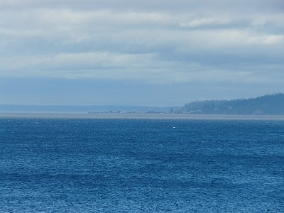
Sultry Pacific air was moving in from the southwest. The dewpoints in the Seattle area soared into the high 60s Fahrenheit. Mass explains:
The humidity is so large that there has been some condensation in the form of shallow fog over parts of the Sound…which is cold enough to cause this moisture to condense. Some wind was also helpful, since it mixed the water vapor towards the cold surface.
A Slow Start, but Gaining Fast
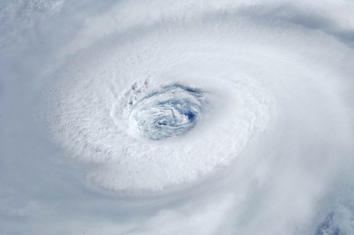
Tropical Storm Lisa became the 12th named storm in the Atlantic Basin this week in what has suddenly become the active 2010 hurricane season that forecasters months ago had predicted. Nine of those twelve storms formed since August 21, with five of them becoming hurricanes. Before that, only one of the first three named storms (Alex) even reached hurricane strength. By contrast, 2005 (9 out of 28) and 2008 (6 out of 16) both had numerous storms form before August 20. Why the delay this year? According to a story in Newscientist.com, a mass of hot, dry air over the oceans stunted the formation of tropical storms. Scientists traced this dry air to a massive ridge of high pressure that sat for months over Europe and Asia, causing an intense heatwave in Russia and severe monsoon rains in Pakistan this summer that killed thousands of people. But just as mid-August arrived, when the typical height of Atlantic hurricane activity is imminent, things changed. As the Weather Underground’s Jeff Masters wrote in his blog on August 17:
Vertical instability, which was unusually low since late July, has now returned to near normal levels over the tropical Atlantic, though it remains quite low over the rest of the North Atlantic. Instability is measured as the difference in temperature between the surface and the top of the troposphere (the highest altitude that thunderstorm tops can penetrate to). If the surface is very warm and the top of the troposphere is cold, an unstable atmosphere results, which helps to enhance thunderstorm updrafts and promotes hurricane development. Since SSTs in the Atlantic were at record highs and upper tropospheric temperatures were several degrees cooler than average in July, enhancing instability, something else must have been going on to reduce instability. Dry air can act to reduce instability, and it appears that an unusually dry atmosphere, due to large-scale sinking over the Atlantic, was responsible for the lack of instability.
Not until the heat wave broke near the end of August did the tropical storms really begin to form in earnest, with four storms (Danielle, Earl, Fiona, and Gaston) arising just between August 21 and September 1. And spurred by those record-high SSTs mentioned by Masters, the 2010 season has not only produced 12 named storms and 6 hurricanes, but 5 major hurricanes–four of them Category 4–making that slow start seem like a distant memory. To put this season in historical perspective, there have been yearly averages of 14 named storms, 8 hurricanes, and 4 major hurricanes since the current active Atlantic hurricane period began in 1995. This season is just one major hurricane away from moving into a 7-way tie for 3rd-most major hurricanes in a season, topped only by the 7 major hurricanes in 1961 and 2005 and 8 in 1950 (lists of most active seasons in various categories can be found here).
How Much Was That Forecast Worth?
Despite the general good fortune that the storm stayed out at sea, there are plenty of grumblings about the cost of Hurricane Earl and more specifically the cost of preparing for it:
Last week’s storm was forecast to be the strongest to hit Long Island’s East End in nearly twenty years. And to handle possible outages, the Long Island Power Authority brought in 1,600 workers from out of state, at an estimated cost of $30 million. LIPA’s budget — already reeling from combating four major storms earlier this year — is now even further in the red.
(Fortunately, LIPA wisely understands the risks that Earl posed:
However, because the storm was supposed to hit such a wide area, LIPA says if it had to do it all over again, it still would’ve brought in those extra workers.)
And further north:
Airlines canceled dozens of flights into New England, and Amtrak suspended train service between New York and Boston….Massachusetts officials estimated that Cape Cod lost about 10 percent of its expected Labor Day weekend business, but were hopeful that last-minute vacationers would make up for it. Gov. Deval Patrick walked around Chatham on Saturday morning, proclaiming, “The sun is out and the Cape is open for business.”
So, as a palliative while people continue to grouse about paying the costs of meteorological uncertainties, read Mike Smith’s post about the savings this time when 450 miles of coastal warnings were issued compared to the much broader-brush (1,500 coastline miles warned) for Hurricane Floyd in 1999.
Instead of warning the entire East Coast as we had to during Floyd, the science of meteorology correctly identified that only the two areas (outer banks and far east Massachusetts) were at risk and warned accordingly. The forecast change in Earl’s direction of movement and rate of weakening were both remarkably good considering this forecast was two days out.
Taking NOAA’s calculations for evacuation costs per mile of coastline, and a reduction of 1,050 miles of warnings in similar situations, and do the math:
OK, now take those 1,050 miles and multiply them by a conservative figure of $700,000 in savings for each mile that correctly was not warned = $735 million dollars! ….And, when you figure in the value-added private sector hurricane forecasts issued by companies like WeatherData and its parent company AccuWeather, the savings grow further, perhaps approaching a billion dollars in total when the correct landfall forecast for Canada is factored in.
Clearly this depends on whether people actually evacuated based on the warnings, but the progress is clear, nonetheless, as are the positive benefits of recent improvements in track forecasts.
Inside Earl
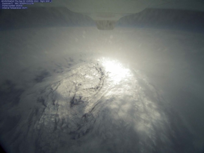
NASA’s GRIP mission (Genesis and Rapid Intensification Processes) is sending aircraft into Hurricane Earl, coming up with some wonderful imagery from almost 20,000 meters above the ocean surface. Here’s how the eye looked from the Global Hawk unmanned aircraft at 9:05 a.m. Eastern, Thursday:
For more on GRIP, Earl, the Global Hawk, and the importance of having drones that can fly up to 26 hours in a single mission, this video interview with Jeff Halverson gives some answers with nice imagery:
Do You Know Which Way the Wind Blows?
Anyone want to help these people with an answer?….Below is a post from Thursday on CASKA, the Chicago Area Sea Kayakers Association web site:
Meteorology Conundrum
Here are wind and waves for this Friday night:
So far so good: the wind is from the west and the waves are predictably building with increasing fetch from Illinois to Michigan side of the lake.
Now here are the predictions for Saturday noon or 15 hours later:
The winds have shifted to the north somewhat but are still predominantly west. The wind shift to the north was gradual. The waves are still gaining height from west to east.
But what happened to the wave direction?! Is it just me or does it seem odd that on the west side of the lake the waves have turned nearly perpendicular to the wind direction!
Time Out for Some…Froth
A break from serious thinking for a moment….
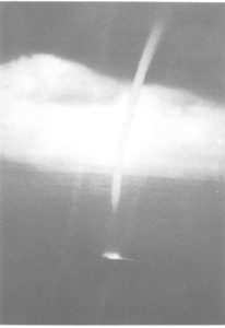
They got too close. Way too close. But thanks to Mike Smith for pointing out this close encounter with a waterspout, which was fun until it was no longer so fun…Which led us to find this even more slick, calculated approach:
So is waterspout hunting the latest crazy extreme sport? Let’s hope not, though sometimes you’re in the right place at the right time:
That’s far cry from what this waterspout does to a ship off Singapore :
Camerman to child: “You want to go up in an airplane? I don’t think it’s a good idea!”
Hmmm, maybe airplanes are how all this got started in the first place:
Vortex Delight
This Monday at the AMS Conference on Mountain Meteorology, Rieke Heinze of the Institut für Meteorologie und Klimatologie at the Leibniz Universität Hannover presented this very cool looking simulation of von Kármán vortex streets, which sometimes show up in satellite images of clouds in the lee of isolated mountain islands. The nifty thing about Heinze’s simulation project is that it shows the vortices retaining a warm core from bottom to top in the flow (cross section not shown here).
On her project web site (where you can download the video), Heinze writes:
Atmospheric vortex streets consist of two rows of counterrotating mesoscale eddies with vertical axis in the wake of large islands. They resemble classical Kármán vortex streets which occur in laboratory experiments behind a cylinder. Usually, atmospheric vortex streets can be found in the stratocumulus capped mixed layer over the ocean when there is a strong elevated inversion well below the island top.
In the animations the island consists of a single Gaussian shaped mountain with a height of about 1.3 km and a base diameter of about 12km. Particles are released in one layer and act as passive tracers. Their vertical motion is disabled. The colour of the particles reflects the difference between the temperature at the respective particle position and the mean temperature, horizontally averaged over the total domain. Blue/red colours represent a relatively low/high temperature. The animation shows that the cores of the eddies are warmer than the environment. The length of the animation corresponds to about 14h real time.
