A session highlight from the 51st Conference on Broadcast Meteorology/7th Conference on Weather Warnings and Communication
By Katie Pflaumer, AMS staff
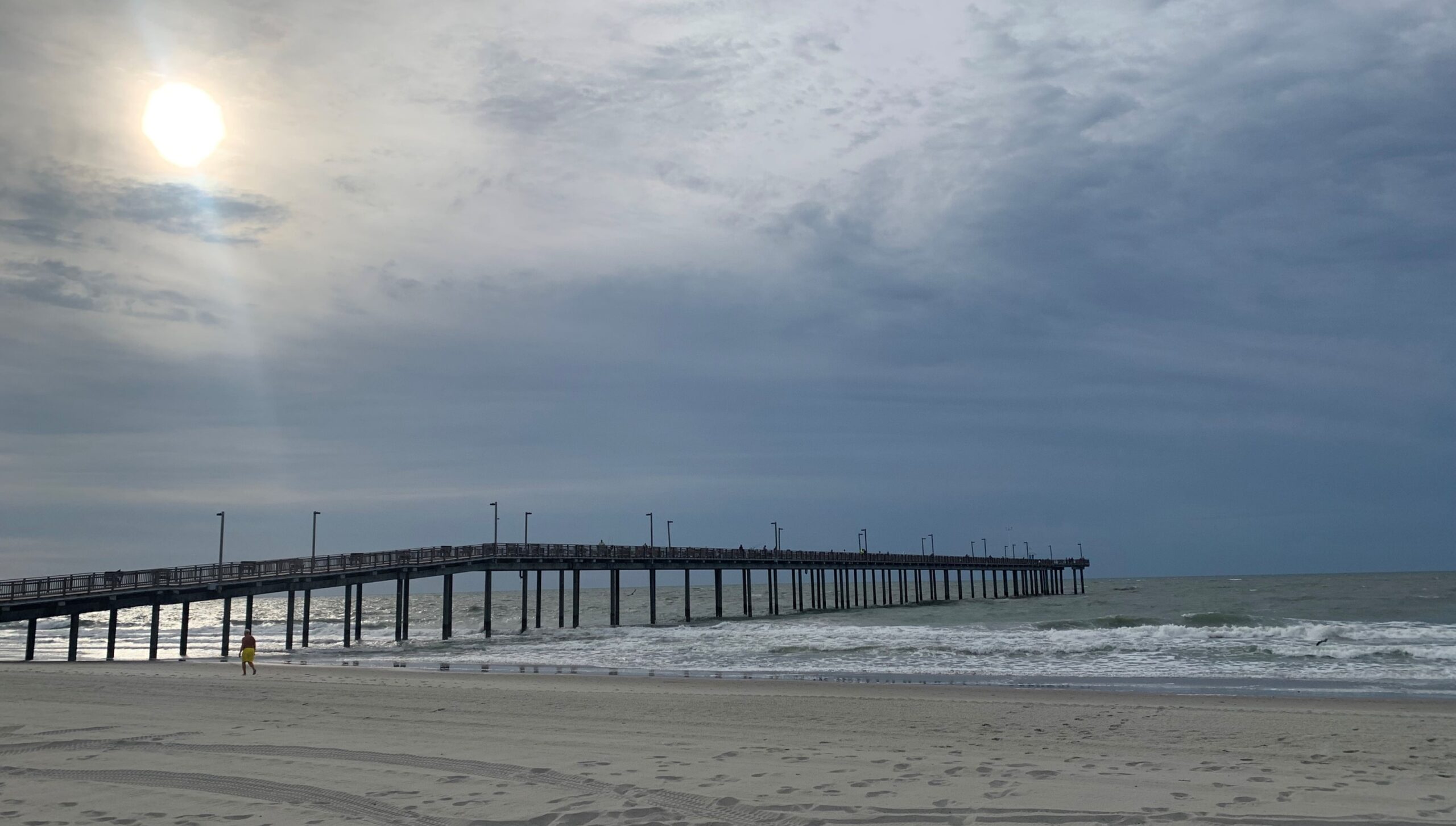
The ocean looked aggressive. It was 6:45 a.m. on June 13 in Myrtle Beach, South Carolina, and my weather app was warning me about the possibilities of dangerous currents. A coastal hazard statement was in effect.
The waves—dark under early-morning cloud—pulled and crashed messily, much stronger than they’d been the day before. Some were coming in at an angle, bending southward down the beach. Whitecaps littered the water’s surface and the air was loud with the waves and wind.
Bruckner Chase was thrilled. “These are exactly the kinds of conditions we’re trying to teach you about,” he said.
I’d met up with him on the beach, along with his NOAA Wave Safe program colleagues Dr. Michelle Evans-Chase and Patrick Roach, other AMS staff, and several broadcast meteorologists who’d signed up for the “Blue IQ: Water, Waves, Weather and Coastal Safety” course at the 51st Conference on Broadcast Meteorology/Seventh Conference on Weather Warnings and Communication. It was an unusual meeting session, organized to help weather communicators—especially broadcast meteorologists—better engage with the public about beach safety.
What follows are a few takeaways from that morning, and from a later Weather Band webinar that recapped the session.
As we walked gradually towards the surf, our discussion focused on the three “zones” of ocean safety—the safe zone, the awareness zone, and the impact zone. There are important things to pay attention to in all three.
Safe Zone
The safe zone—far back from where any waves might reach—is a place to take inventory and get the lay of the land, as well as making sure you have all the supplies you may need.
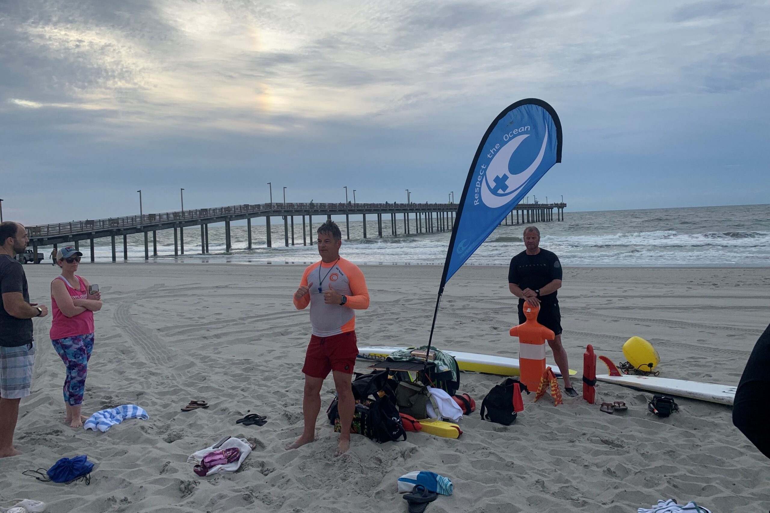
Wait and Watch. The ocean, as Chase noted, is a constantly changing environment. The most important thing you can do is to pay attention. “Every beach is different [and due to tidal changes], that beach is also different from morning to afternoon,” said Chase during the webinar. “[If] you’ve got a sandbar that was under 3 feet of water and is now under 6 inches … now it’s become dangerous.”
Note any hazards (like piers or areas where waves are breaking strangely) and think about the height, direction, and roughness of the waves. Wind direction will impact wave behavior, and winds coming from the ocean or along the beach can make for more challenging conditions. Take time to observe what’s happening.
“Many people will look [at the waves] for a minute or two and go, oh, it’s fine. I watch the water 10 to 15 minutes at least, because waves will come in sets, conditions will change, it’s not always the same.”
—Bruckner Chase
Listen to the Experts. Lifeguards and surfers are often great sources for information about your beach. Always swim near lifeguards and pay attention to any signs or messaging about when and where you can swim safely.
Weather Aware. Conditions at the nearest weather reporting station may not reflect conditions at the coast. For example, in early summer, cold water and warm air can create dense fog right along the beach. “It can get to where you can’t see the shore,” said Michelle Evans-Chase. Weather communicators can help make their audience aware of these possible localized events.
Yet the general weather forecast is still important. If a storm is approaching, for example, people need to know to get out of the water and off the beach, as lightning can strike miles ahead of a storm.
Hazards and Tides. Your weather forecast office may also issue information about beach hazards. They had done so for Myrtle Beach today: strong longshore currents (running parallel to the beach) were highly likely, and rip currents (which can pull swimmers out towards the ocean) were moderately likely. Weather reports may also list the times of high and low tide, which can dramatically impact water conditions due to depth changes across sand bars or submerged hazards. Be careful around inlets when the tide is changing; strong tidal-driven currents may funnel through calm-appearing waters.
From our vantage point the day of the session, we could see signs of the longshore current scrambling the waves. Beach forecasts often include rip current risk, but longshore currents can also be very dangerous, sweeping you down the beach and making it hard to get back to shore. If you’re on a small beach surrounded by more challenging terrain, such a current could even drag you past the safe landing area. A final note on the safe zone: Make sure you know where it actually is. “Sneaker” waves—unusually large waves—may come much farther up the beach than expected. On rocky shorelines (common in the Pacific Northwest), these waves can pull people off the rocks into very cold water. The same can happen on piers and jetties. Even if a vantage point appears safe, heed any signage telling you not to go out there, and always pay attention to what’s happening in the water.
Awareness Zone
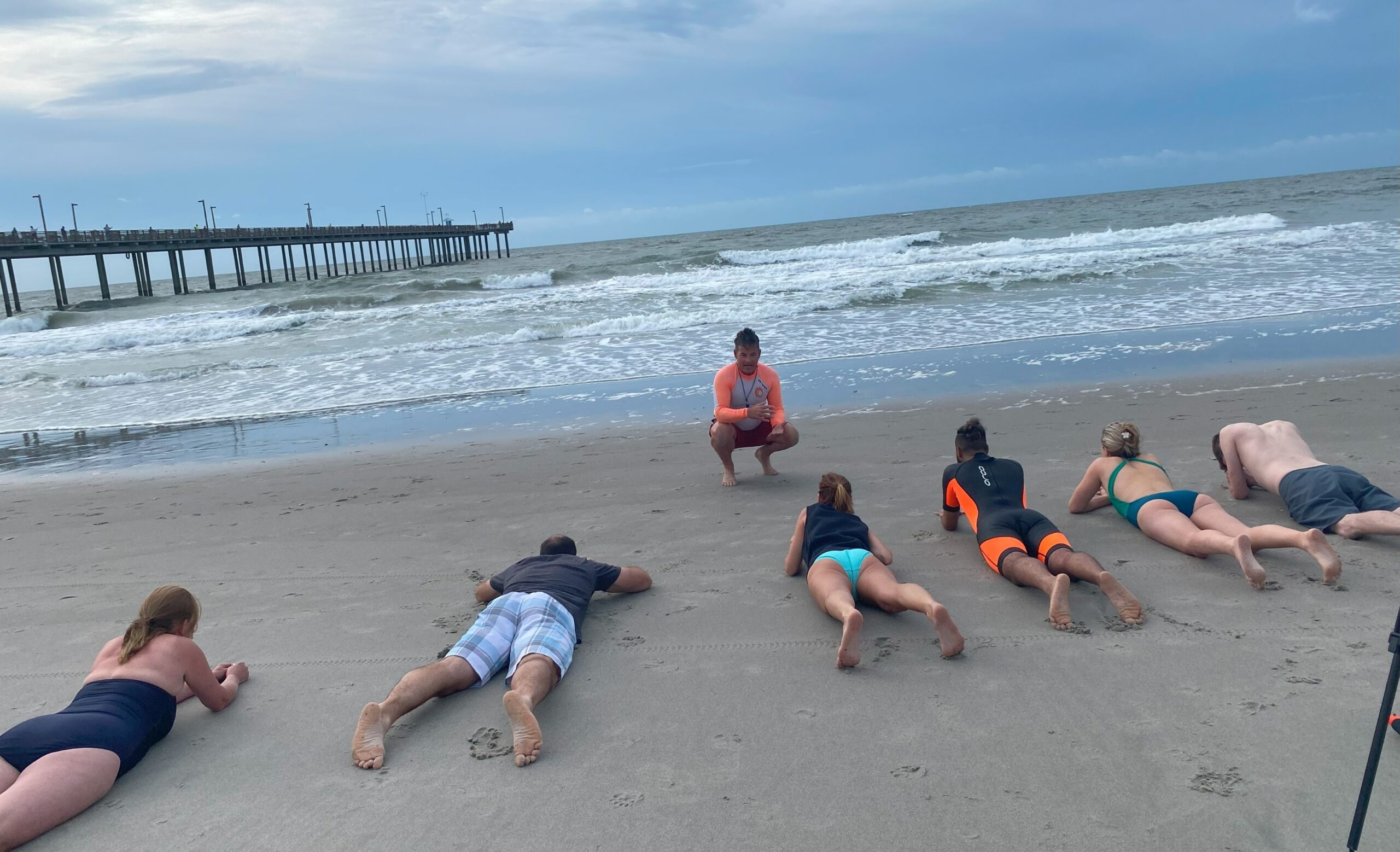
Once you walk closer to the surf, you’ll have a better sense of what your ocean experience will be like. When our little class left the area of the dunes, we were less shielded from the wind, and the waves seemed louder and taller than when we’d looked at them from above. Chase had us all lie down near the edge of the water, noting how large two- or three-foot waves can seem once you’re in them. Getting hit by even a smallish wave at the wrong angle can cause serious injury, so never underestimate surf.
“If … it’s your first trip to the beach, two feet doesn’t sound like much. … But a mass of water moving at you every six seconds that’s two feet high is a lot different and harder to navigate.”
—Bruckner Chase
Prepare to get in the water by orienting yourself. Line yourself up with a very specific landmark—pick something colorful and uniquely shaped that you can look back and easily identify (we used the water slide in front of our hotel). This is also important in an emergency, as EMS will need to know where to enter the beach to get to you.
Impact Zone
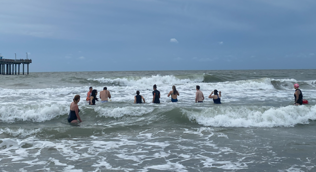
The impact zone, more technically known as the swash zone, is where waves are washing up on the sand and receding. This is where you’re getting into the water.
Be Prepared. Depending on water temperature, be prepared for a cold shock that could impact motor function. As Chase reminded us, “If you’re in a dangerous situation [and numb from the cold], you may lose the ability to effectively move out of it.” Be aware that the beach can drop off rapidly, and you could suddenly find yourself deeper than expected.
Move Efficiently. Chase outlined techniques for making efficient progress through the surf and conserving energy. Walking in sideways means less of your body has to fight through a wave. Diving underneath approaching waves can be another good way to make progress; things are much more peaceful under the water. Stick your fingers in the sand to make sure you go deep enough and to help you stay oriented.
Remain Calm. Chase’s techniques worked well, yet we all struggled to get out into waist deep water the morning of the session. The longshore current pulled relentlessly, and the waves—which hit us every few seconds as they piled up close to shore—made me grateful to be surrounded by trained lifeguards. Even with our feet mostly on the ground, we were soon swept 30-40 meters down the beach. If we’d gone out further, the currents might have made it hard to get back in.
If you’re caught in a rip current, standard advice is to swim perpendicular to the direction the current is moving you to escape this narrow, ocean flowing band of water (which will normally weaken once you get further out). Then, carefully swim at an angle towards the shore, always being aware of large waves that may be coming up behind you.
If you’re struggling in a longshore/long beach current, however, the best course of action is to head directly for the beach, which will be perpendicular to that current. Don’t worry too much about exiting the water exactly where you started—just get out where you can. Chase noted that while many people have heard what to do in a rip current, few are aware of the strength of longshore currents that can move you hundreds of yards or more along a beach.
Even if you’re a strong swimmer in the pool, don’t expect to feel equally strong and fast in the ocean, even on a calm day. “Most swimmers are going to have trouble navigating these dynamic conditions and feeling as comfortable in the surf as they do at their local swimming pool,” Chase told us. So the key thing to remember in a dangerous situation is: relax. Stay calm and use your energy tactically. “Give people time to come and help you, for the EMS system to be activated, for a lifeguard to come and find you.” If you see someone in trouble, take 10 seconds to alert a lifeguard or 911 and find productive ways to help. Watch the NOAA Wave Safe “Take 10” video.
No matter what beach you go to, the philosophy is, respect the ocean. “Even if you’ve been visiting the same beach for 10 years and you know that break and you’re comfortable sending your kids out there, one nor’easter or one storm can dramatically change that,” said Chase. “So it’s not just [that] each beach is different, which it very much is, but that beach can also change from hour to hour and definitely from year to year.”
Learn More
Share NOAA’s Wave Safe videos to help your friends and family, or the public at large, understand beach safety concepts.
View a news story by Blue IQ session attendee Jeremy Lewan, featuring some of his takeaways from the session.
Watch the Weather Band Webinar.
Read Bruckner Chase’s Weather Band article for additional tips.
See experimental beach forecasts at Weather.gov/beach.
More NOAA beach safety resources.
About 51Broadcast/7WWC
The 51st Conference on Broadcast Meteorology and Seventh Conference on Weather Warnings and Communication took place in Myrtle Beach, South Carolina, on 12-14 June, 2024, hosted by the American Meteorological Society (AMS). The 51st Conference on Broadcast Meteorology is organized by the AMS Board on Broadcast Meteorology and invites broadcast meteorologists from across the United States to network and share professional knowledge. The Seventh Conference on Weather Warnings and Communication features cutting-edge research on weather communication strategies, challenges, and impacts, and is organized by the AMS Board on Societal Impacts.