Saildrone’s Science at the Air–Sea Interface

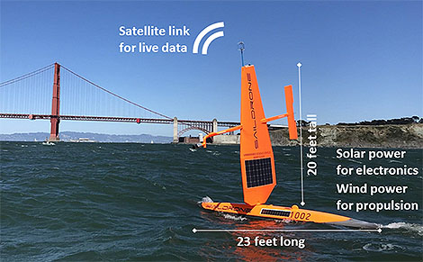
The Saildrone vehicle returning to San Francisco on 11 Jun 2018. The wind anemometer is visible at the top of the wing and solar panels are on both the wing and the vehicle hull. Image credit: Saildrone/Gentemann.
The Saildrone vehicle returning to San Francisco on June 11, 2018. The wind anemometer is visible at the top of the wing and solar panels are on both the wing and the vehicle hull. Image credit: Saildrone/Gentemann.


You’ve heard of drones in the air, but how about on the ocean’s surface? Enter Saildrone: A new wind and solar powered ocean-observing platform that carries a sophisticated suite of scientific sensors to observe air–sea fluxes. Looking like a large windsurfer without the surfer, the sailing drone glides autonomously at 2–8 kts. along the surface of uninhabited oceans on missions as long as 12 months, sampling key variables in the marine environment.

In a recent paper published in the Bulletin of the American Meteorological Society, author Chelle Gentemann and her colleagues explain that from April 11 to June 11, 2018, Saildrone cruised on a 60-day round trip from San Francisco down the coast to Mexico’s Guadelupe Island to establish the accuracy of its new measurements. These were made to validate air–sea fluxes, sea surface temperatures, and wind vectors derived by satellites. The automated surface vehicle also studied upwelling dynamics, river plumes, and the air–sea interactions of both frontal and diurnal warming regions on this deployment—meaning Saildrone’s versatile array of instruments got a workout not only above surface but just below it as well, in the water along the hull.

BAMS asked a few questions of the authors to gain insight into their research as well as their backgrounds. A sampling of answers are below:

Chelle Gentemann
Chelle Gentemann

BAMSWhat would you like readers to learn from your article?

Chelle Gentemann, Farallon Institute: New measurement approaches are always being developed, allowing for new approaches to science. Understanding a dataset’s characteristics and uncertainties is important to have confidence in derived results.

BAMSHow did you become interested in working with Saildrone?

Gentemann: The ocean is a challenging environment to work in: it can be beautiful but dangerous, and gathering ship observations can require long absences from your family.  I learned about Saildrones in 2016 and wanted to see how an autonomous vehicle might be able to gather data at the air–sea interface and adapt sampling to changing conditions.  There are some questions that are hard to get at from existing remote sensing and in situ datasets; I thought that if these vehicles are able to collect high-quality data, they could be useful for science.

BAMSHow have you followed up on this experiment? 

Gentemann: We sent two more [Saildrones] to the Arctic last Summer (2019) and are planning for two more in 2021.  There are few in situ observations in the Arctic Ocean because of the seasonal ice cover, so sending Saildrones up there for the summer has allowed us to sample temperature and salinity fronts during a record heat wave.

Sebastien de Halleux, Saildrone, Inc.: I believe we are on the cusp of a new golden age in oceanography, as a wave of new enabling technologies is making planetary-scale in situ observations technically and economically feasible. The fact that Saildrones are zero-emission is a big bonus as we try to reduce our carbon footprint. I am excited to engage further with the science community to explore new ways of using this technology and developing tools to further the value of the data collected for the benefit of humanity.

BAMSWhat got you initially interested in oceanography?

de Halleux: Having had the opportunity to sail across the Pacific several times, I developed a strong interest in learning more about the 70% of the planet covered by water—only to realize that the challenge of collecting data is formidable over such a vast domain. Being exposed to  the amazing power of satellites to produce large-scale remote sensing datasets was only tempered by the realization of their challenges with fine features, land proximity, and of course the need to connect them to subsurface phenomena. This is how we began to explore the intersection of science, robotics, and big data with the goal to help enable new insights. Yet we are only at the beginning of an amazing journey.

BAMS: What surprises/surprised you the most about Saildrone’s capabilities?

Peter Minnett, Univ. of Miami, Florida: The ability to reprogram the vehicles in real time to focus on sampling and resampling interesting surface features. The quality of the measurements is impressive.

Saildrones are currently deployed around the world. In June 2019 , there were three circumnavigating Antarctica, six in the U.S. Arctic, seven surveying fish stock off the U.S. West Coast and two in Norway, four surveying the tropical Pacific, and one conducting a multibeam bathymetry survey in the Gulf of Mexico. In 2020, Saildrone, Inc. has deployed fleets in Europe, the Arctic, the tropical Pacific, along the West Coast, the Gulf of Mexico, the Atlantic, the Caribbean, and Antarctica. NOAA and NASA-funded Saildrone data are distributed openly and publicly.
Saildrone's Science at the Air–Sea Interface

The Saildrone vehicle returning to San Francisco on 11 Jun 2018. The wind anemometer is visible at the top of the wing and solar panels are on both the wing and the vehicle hull. Image credit: Saildrone/Gentemann.
The Saildrone vehicle returning to San Francisco on June 11, 2018. The wind anemometer is visible at the top of the wing and solar panels are on both the wing and the vehicle hull. Image credit: Saildrone/Gentemann.

 
You’ve heard of drones in the air, but how about on the ocean’s surface? Enter Saildrone: A new wind and solar powered ocean-observing platform that carries a sophisticated suite of scientific sensors to observe air–sea fluxes. Looking like a large windsurfer without the surfer, the sailing drone glides autonomously at 2–8 kts. along the surface of uninhabited oceans on missions as long as 12 months, sampling key variables in the marine environment.
In a recent paper published in the Bulletin of the American Meteorological Society, author Chelle Gentemann and her colleagues explain that from April 11 to June 11, 2018, Saildrone cruised on a 60-day round trip from San Francisco down the coast to Mexico’s Guadelupe Island to establish the accuracy of its new measurements. These were made to validate air–sea fluxes, sea surface temperatures, and wind vectors derived by satellites. The automated surface vehicle also studied upwelling dynamics, river plumes, and the air–sea interactions of both frontal and diurnal warming regions on this deployment—meaning Saildrone’s versatile array of instruments got a workout not only above surface but just below it as well, in the water along the hull.

BAMS asked a few questions of the authors to gain insight into their research as well as their backgrounds. A sampling of answers are below:

Chelle Gentemann
Chelle Gentemann

BAMSWhat would you like readers to learn from your article?

Chelle Gentemann, Farallon Institute: New measurement approaches are always being developed, allowing for new approaches to science. Understanding a dataset’s characteristics and uncertainties is important to have confidence in derived results.
BAMSHow did you become interested in working with Saildrone?
Gentemann: The ocean is a challenging environment to work in: it can be beautiful but dangerous, and gathering ship observations can require long absences from your family.  I learned about Saildrones in 2016 and wanted to see how an autonomous vehicle might be able to gather data at the air–sea interface and adapt sampling to changing conditions.  There are some questions that are hard to get at from existing remote sensing and in situ datasets; I thought that if these vehicles are able to collect high-quality data, they could be useful for science.
BAMSHow have you followed up on this experiment? 
Gentemann: We sent two more [Saildrones] to the Arctic last Summer (2019) and are planning for two more in 2021.  There are few in situ observations in the Arctic Ocean because of the seasonal ice cover, so sending Saildrones up there for the summer has allowed us to sample temperature and salinity fronts during a record heat wave.
Sebastien de Halleux, Saildrone, Inc.: I believe we are on the cusp of a new golden age in oceanography, as a wave of new enabling technologies is making planetary-scale in situ observations technically and economically feasible. The fact that Saildrones are zero-emission is a big bonus as we try to reduce our carbon footprint. I am excited to engage further with the science community to explore new ways of using this technology and developing tools to further the value of the data collected for the benefit of humanity.
BAMSWhat got you initially interested in oceanography?
de Halleux: Having had the opportunity to sail across the Pacific several times, I developed a strong interest in learning more about the 70% of the planet covered by water—only to realize that the challenge of collecting data is formidable over such a vast domain. Being exposed to  the amazing power of satellites to produce large-scale remote sensing datasets was only tempered by the realization of their challenges with fine features, land proximity, and of course the need to connect them to subsurface phenomena. This is how we began to explore the intersection of science, robotics, and big data with the goal to help enable new insights. Yet we are only at the beginning of an amazing journey.
BAMS: What surprises/surprised you the most about Saildrone’s capabilities?
Peter Minnett, Univ. of Miami, Florida: The ability to reprogram the vehicles in real time to focus on sampling and resampling interesting surface features. The quality of the measurements is impressive.
Saildrones are currently deployed around the world. In June 2019 , there were three circumnavigating Antarctica, six in the U.S. Arctic, seven surveying fish stock off the U.S. West Coast and two in Norway, four surveying the tropical Pacific, and one conducting a multibeam bathymetry survey in the Gulf of Mexico. In 2020, Saildrone, Inc. has deployed fleets in Europe, the Arctic, the tropical Pacific, along the West Coast, the Gulf of Mexico, the Atlantic, the Caribbean, and Antarctica. NOAA and NASA-funded Saildrone data are distributed openly and publicly.
Cruising the Ocean’s Surface Microlayer

Oceans are deep, and they are integral to the climate system. But the exchanges between ocean and atmosphere that preoccupy many scientists are not in the depths but instead in the shallowest of shallow layers.
A lot happens in the topmost millimeter of the ocean, a film of liquid called the “sea-surface microlayer that is, in many ways, a distinct realm. At this scale, exchanges with the atmosphere are more about diffusion, conduction, and viscosity than turbulence. But the layer is small and difficult to observe undisturbed and over sufficient areas. As a result, “it has been widely ignored in the past,” according to a new paper by Mariana Ribas-Ribas and colleagues in the Journal of Atmospheric and Oceanic Technology.
Nonetheless, Ribas-Ribas and her team, based in Germany, looked for a new way to skim across and sample the critical top 100 micrometers (one tenth of a millimeter) of the ocean. This surface microlayer (SML) “plays a central role in a range of global biogeochemical and climate-related processes.” However, Ribas-Ribas et al. add,

The SML often has remained in a distinct research niche, primarily because it was thought that it did not exist in typical oceanic conditions; furthermore, it is challenging to collect representative SML samples under natural conditions.

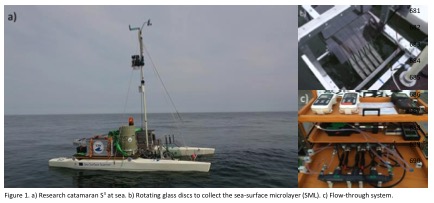
In their paper (now in early online release), the authors report on their solution to observing is a newly outfitted remote-controlled catamaran. A set of rotating glass discs with holes scoops up water samples. Pictured below are the catamaran and (at left, top) the glass discs mounted between the hulls and (bottom left) the flow-through system.
catamaran
Catamarans are not new to this research, but they were generally towed behind other vessels and subject to wake effects or were specialized. The new Sea Surface Scanner (S3) takes advantage of better remote control and power supply technology and can pack multiple sampling and sensors and controls onto one platform. Tests in the Baltic Sea last year showed the ability of S3 to track responses of organisms in the surface microlayer to ocean fronts, upwelling areas, and rainfall. The biological processes in turn affect critical geochemical processes like exchanges of gases and production of aerosols for the atmosphere.
The technology may be a fresh start for research looking in depth at the shallowest of layers. See the journal article for more details on the S3 and its performance in field tests.
 

Decadal Survey of Ocean Sciences

Dr. David Titley, Rear Adm. (Ret.)–well known to us as former oceanographer of the U.S. Navy, as chief operating officer at NOAA, now as a professor at Penn State’s Department of Meteorology–and of course as an AMS Fellow–writes to us asking for your input on a new project:

As you may know, the National Research Council (NRC) is now conducting a Decadal Survey of Ocean Sciences (DSOS 2015), sponsored by the National Science Foundation. Shirley Pomponi (Harbor Branch/Florida Atlantic University) and I are the co-chairs.
This study will review the current state of knowledge, identify compelling scientific questions for the next decade, analyze infrastructure needed to address these questions vs. the current NSF portfolio, and identify opportunities to maximize the value of NSF investments.
The DSOS committee feels strongly that this report must be informed by broad and thoughtful community input from across the entire spectrum of ocean sciences supported by NSF. The DSOS committee will be holding town hall sessions at the AGU Annual Meeting in San Francisco in December and at the ASLO/TOS/AGU Ocean Sciences Annual Meeting in Honolulu in February 2014. In addition to soliciting comments at the professional meetings, we are seeking community input through a “virtual” town hall: http://nas-sites.org/dsos2015/.
The website provides more detailed information on the statement of task, as well as a complete list of the DSOS committee members. Please go to the website and contribute your comments regarding the top ocean science priorities for the next decade. Thank you very much in advance for supporting the Ocean Studies Board and the NRC in this important effort.

Take a Dip in the Wild Ocean

If you haven’t gotten your fill of science at the meeting, there’s more at the Fernbank Museum of Natural History. The museum strives to inspire life-long learning of natural history through dynamic programming and interactive science displays.

The forest tower at Fernbank Science Center is festooned with meteorological instruments, contributing to the WeatherBug network.

Along with their permanent exhibits, this month features a special exhibit, “My Favorite Things.” For the exhibit, each department chose a natural history piece from storage to put on display.  The exhibit by nature is designed to appeal to scientists of all ages and fields in its diversity.
Of special interest to oceanographers, “Wild Ocean” is playing at the IMAX theater. Filmed on South Africa’s wild coast, the movie touches on the balance not only between the oceans and people but the relationship between all living things. Showing through March 11, show times are Monday through Saturday 11:00, 1:00, 3:00, and 5:00, with a 9:15 p.m. showing on Friday; and Sunday 1:00, 3:00, and 5:00.
We would tell you about the 7 p.m. extra showing this Friday (shhh!), but instead that’s when Richard Somerville author of the AMS-published book, The Forgiving Air, will give a talk on climate change at the museum.

Charting the Course of Arctic Warmth…and Oceanography

While many parts of the country have recently been experiencing conditions that residents might call “Arctic,” the Arctic region itself has been warming since at least the early 1990s, reaching warmth unprecedented in the last century. The consequences for global climate are potentially critical―particularly if fresh water from melting ice and increased atmospheric precipitation in the Arctic slow the overturning circulation of the North Atlantic. With Arctic sea ice melting dramatically in recent years, scientists  are trying to understand the influence of the warmer water that flows into the Arctic from the North Atlantic.
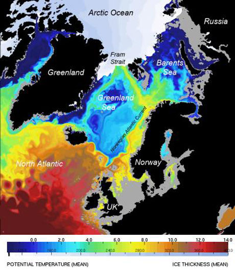
At the National Oceanography Centre (NOCS) in Southampton, United Kingdom, scientists using high-resolution computer models found that from 1989 to 2009, about 50% of the salty North Atlantic water entering the Arctic Ocean came through Fram Strait, a deep channel between Greenland and the Norwegian island of Spitsbergen that connects the Nordic Seas to the Arctic Ocean. The Barents Sea contributes about as much Atlantic water to the Arctic, but the Fram Strait water carried most of the heat that has been a primary cause of Arctic ice melting.
An example of the modeling in this study, published in the January 2010 issue of Journal of Marine Systems, can be seen in the image below, which shows a computer simulation of ocean temperatures at a depth of 100 meters and sea ice thickness in September 2006. The pathways of warm saline water toward the Arctic have previously been poorly understood, but here the 8-km resolution defines three distinct pathways for this water to move under the more pure Arctic water, thus pumping heat northward between 50 and 170 meters below the surface.
“Computers are now powerful enough to run multidecadal global simulations at high resolution,” said NOCS scientist Yevgeny Aksenov. “This helps to understand how the ocean is changing and to plan observational programs so as to make measurements at sea more efficient.”
Ocean-climate interactions are a primary focus of the ocean science research priorities recommended by the U.S. National Science and Technology Council’s Joint Subcommittee on Ocean Science and Technology (JSOST) in their 2007 report, “Charting the Course for Ocean Science in the United States for the Next Decade: An Ocean Research Priorities Plan and Implementation Strategy.” As our understanding continues to evolve regarding the ocean and its influence on the Earth system, the priorities outlined in this report have also evolved. A town hall meeting on “Refreshing Our Ocean Research Priorities” (Monday, 12:15–1:15 p.m., B212) at the upcoming AMS Annual Meeting will explore some of these developments and give participants a forum to discuss topics of interest with the chairs of JSOST.

arctic_sea_update