“Megaflashes”: How Long Can a Lightning Discharge Be?

Even though Earth’s atmosphere is laced by more than a billion brilliant discharges of electricity every year, lightning itself never seems ordinary. But there’s a broad range of lightning, and sometimes, at the extreme, it’s possible to recognize a difference between the ordinary and amazing, even among lightning flashes. The challenge is finding and observing such extremes.

New research by Walt Lyons and colleagues, published in BAMS, reports such a perspective-altering observation of long lightning flashes. To appreciate the observation, consider first the “ordinary” lightning flash. The charge center of the cloud itself is typically 6–10 km above ground. And from there the lightning doesn’t necessarily go straight down: it may extend horizontally, even 100 km or more. Typical lightning might be best measured in kilometers or a few tens of kilometers.

A world record flash in 2007 meandered across Oklahoma for “approximately 300 km.” But that may be a mere cross-counties commute compared to newly discovered interstate “megaflashes” that are almost twice as long. One such megaflash, as the BAMS paper names them, sparked across the sky for ~550 km from northeast Texas across Oklahoma to southeast Kansas in October 2017. And this megaflash, too, may not be the longest ̶ it just happened to occur within the Oklahoma lightning mapping array (OK LMA), allowing for its full study.

Time integrated GLM radiances over 7.18s beginning at 0513:27.433 UTC on 22 October 2017. Two distinct electrical regimes are evident. The first is the cluster of smaller flashes in the leading line of convective cells stretching from eastern Oklahoma and then southwest into north Texas. The second regime is an extensive horizontal flash propagating from near the Red River in Texas across central Oklahoma into southeastern Kansas.
Time-integrated satellite (GLM) radiances over 7.18s beginning at 0513:27.433 UTC on 22 October 2017. Two distinct electrical regimes are evident. The first is the cluster of smaller flashes in the leading line of convective cells stretching southwest from eastern Oklahoma into north Texas. The second is the horizontal megaflash propagating from near the Red River in Texas across central Oklahoma into southeastern Kansas.


Also, just like the official record flash, which produced 13 cloud-to-ground (CG) lightning strikes, including two triggering sprites that shot high into the atmosphere, this horizontal megaflash also triggered a plethora of CG bolts, in-cloud discharges, and upward illuminations during its 7.18 second lifespan.

The new Geostationary Lightning Mapper sensor on the GOES-16/17 satellite has become the latest tool suited to investigating long-path lightning. The BAMS paper says the sensor is showing that a megaflash “appears able to propagate almost indefinitely as long as adequate contiguous charge reservoirs exist” in the clouds. Such conditions seem to be present in mesoscale convective systems—large conglomerates of thunderstorms that extend rainy stratiform clouds across many hundreds of km. The paper adds,

Megaflashes also pose a safety hazard, as they can be thought of as the stratiform region’s version of the ‘bolt-from-the blue,’ sometimes occurring long after the local lightning threat appears to have ended. But some key questions remain – what is the population of megaflashes and how long can they actually become?

The authors conclude:

Is it possible that a future megaflash can attain a length of 1000 km? We would not bet against that. Let the search begin.

"Megaflashes": How Long Can a Lightning Discharge Be?

Even though Earth’s atmosphere is laced by more than a billion brilliant discharges of electricity every year, lightning itself never seems ordinary. But there’s a broad range of lightning, and sometimes, at the extreme, it’s possible to recognize a difference between the ordinary and amazing, even among lightning flashes. The challenge is finding and observing such extremes.
New research by Walt Lyons and colleagues, published in BAMS, reports such a perspective-altering observation of long lightning flashes. To appreciate the observation, consider first the “ordinary” lightning flash. The charge center of the cloud itself is typically 6–10 km above ground. And from there the lightning doesn’t necessarily go straight down: it may extend horizontally, even 100 km or more. Typical lightning might be best measured in kilometers or a few tens of kilometers.
A world record flash in 2007 meandered across Oklahoma for “approximately 300 km.” But that may be a mere cross-counties commute compared to newly discovered interstate “megaflashes” that are almost twice as long. One such megaflash, as the BAMS paper names them, sparked across the sky for ~550 km from northeast Texas across Oklahoma to southeast Kansas in October 2017. And this megaflash, too, may not be the longest ̶ it just happened to occur within the Oklahoma lightning mapping array (OK LMA), allowing for its full study.

Time integrated GLM radiances over 7.18s beginning at 0513:27.433 UTC on 22 October 2017. Two distinct electrical regimes are evident. The first is the cluster of smaller flashes in the leading line of convective cells stretching from eastern Oklahoma and then southwest into north Texas. The second regime is an extensive horizontal flash propagating from near the Red River in Texas across central Oklahoma into southeastern Kansas.
Time-integrated satellite (GLM) radiances over 7.18s beginning at 0513:27.433 UTC on 22 October 2017. Two distinct electrical regimes are evident. The first is the cluster of smaller flashes in the leading line of convective cells stretching southwest from eastern Oklahoma into north Texas. The second is the horizontal megaflash propagating from near the Red River in Texas across central Oklahoma into southeastern Kansas.

 
Also, just like the official record flash, which produced 13 cloud-to-ground (CG) lightning strikes, including two triggering sprites that shot high into the atmosphere, this horizontal megaflash also triggered a plethora of CG bolts, in-cloud discharges, and upward illuminations during its 7.18 second lifespan.
The new Geostationary Lightning Mapper sensor on the GOES-16/17 satellite has become the latest tool suited to investigating long-path lightning. The BAMS paper says the sensor is showing that a megaflash “appears able to propagate almost indefinitely as long as adequate contiguous charge reservoirs exist” in the clouds. Such conditions seem to be present in mesoscale convective systems—large conglomerates of thunderstorms that extend rainy stratiform clouds across many hundreds of km. The paper adds,

Megaflashes also pose a safety hazard, as they can be thought of as the stratiform region’s version of the ‘bolt-from-the blue,’ sometimes occurring long after the local lightning threat appears to have ended. But some key questions remain – what is the population of megaflashes and how long can they actually become?

The authors conclude:

Is it possible that a future megaflash can attain a length of 1000 km? We would not bet against that. Let the search begin.

The New Capital of Lightning

Imagine being awoken late one night by the near constant glow of lightning overhead—often flickering silently but occasionally rumbling deeply with a strike nearby. Then it happens the same time the next night—and the next, and the next, sometimes lasting for many hours at a time.
Now imagine the nocturnal fireworks happening nearly 300 days per year.
Welcome to Lake Maracaibo, Venezuela.
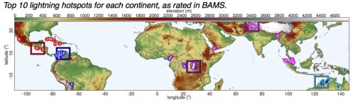
Based on a scientific paper just released by the Bulletin of the American Meteorological Society (BAMS), the Lake Maracaibo region is the newly crowned lightning capital of the world, taking the throne from a celebrated thunderstorm-prone region of Africa.
Lake Maracaibo, the largest lake in South America, is already well known for its lightning. Boats take tourists onto the water to watch the storms, and the flag of the region—the State of Zulia—features a lightning bolt in honor of the lake’s prolific displays.200px-Flag_of_Zulia_State.svg
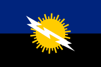
Nonetheless, Africa’s Congo Basin had previously been identified by scientists as the world’s lightning hotspot. It stayed that way for several years until the new BAMS article (available online) recalculated rankings based on a new, high-resolution dataset of satellite observations of the lightning flash-rate density.
Lake Maracaibo’s pattern of convergent wind flow–mountain–valley, lake, and sea breezes–occurs over warm lake waters nearly year-round and contributes to nocturnal thunderstorm development 297 days per year on average, with a peak in September. These thunderstorms are very localized and their persistent development anchored in one location accounts for the high flash-rate density. While practically the whole lake is averaging 50 flashes per year, only a small portion qualifies as the world leading hotspot, with more than 232 flashes per square kilometer per year (including cloud-to-ground and cloud-to-cloud lightning).
The BAMS article, “Where are the Lightning Hotspots on Earth?” by Rachel I. Albrecht, Steven J. Goodman, Dennis E. Buechler, Richard J. Blakeslee, and Hugh J. Christian, is derived from 16 years of observations by the Lightning Imaging Sensor aboard the now defunct NASA Tropical Rainfall Measurement Mission satellite.
The team—representing the University of Maryland, Universidade de São Paulo (Brazil), NOAA, NASA, and the University of Alabama in Huntsville—cites several factors for the new lightning champion, including its unique geography and climatology. Storms mostly form during the nighttime hours, after the tropical heating of the day allows warm Caribbean air to mix with colder Andes Mountain air. According to the article, “Nocturnal thunderstorms over Lake Maracaibo are so frequent that their lightning activity was used as a lighthouse by Caribbean navigators in colonial times.”

lightning hot spots

The authors noted that previous studies, using the same satellite capabilities, missed the localized peak at Lake Maracaibo for several reasons. Coarser resolution was one problem (the new study partitions the lake into 20 times more sectors than earlier studies), but so were filtering of high-density outbursts of lightning and calculations made to compensate for limited samples of sparse lightning areas. Where the previous studies were aimed at getting the first useful global overviews, the new study is calibrated to identify hotspots.
Located near the border of the Congo and Rwanda, the now second-ranked Kahuzi-Biéga National Park in Kabare has its own mountainous geography that allows five different locations in the region to rank in the top 10 for lightning flash-rate density. Previous research had shown that the Congo basin boasted the largest flash rate per thunderstorm, and the region still has the world’s largest average flash rate density for any particular part of the day. It averages 5.5 flashes per hour at about 5:30 p.m. local time within a 1° latitude x 1° longitude box. That rate is nearly matched by Lake Maracaibo averaging more than 5.4 flashes per hour at about 3 a.m., when nighttime winds descending the mountain valleys converge over the ever-warm lake waters.
Both of the top two hotspots have lengthy lightning “seasons” but neither had a peak spell matching the 90 flashes per day in early August in the 1° x 1° region of Majagual, Colombia.
Before satellite observations were available, scientists estimated that the whole Earth at any one time experienced about 100 flashes per second. Satellite evidence has reduced that estimate to about 44 to 46 flashes per second, which means Earth experiences nearly 1.4 billion lightning flashes per year. The rate is 20% higher during Northern Hemisphere summer. This variation is in part due to the larger amount of land north of the equator, which lends itself to the surface heating that fuels thunderstorms.
The new BAMS study confirms previous findings showing that lightning activity tends to happen at night in areas closer to mountain ranges and/or coasts but continental-wide lightning activity peaks during the afternoons. And yet the new king of lightning is over water and peaks at night.
The new list of the world’s top 10 lightning flash-rate density hotspots (shown below) includes no sites from North America. Four locations, in Guatemala, Cuba, and Haiti, had more than 100 flashes per square km per year (led by 117 in Patulul, Guatemala). The most lightning prone U.S. location, ranked 122nd globally, was in the Everglades not far from Ft. Myers, Florida, with 79 flashes per square km per year.

World rank

Flash-rate density


Location

1

232.52

Lake Maracaibo, Venezuela

2

205.31

Kabare, Dem. Rep. of Congo

3

176.71

Kampene, Dem. Rep. of Congo

4

172.29

Caceres, Colombia

5

143.21

Sake, Dem. Rep. of Congo

6

143.11

Dagar, Pakistan

7

138.61

El Tarra, Colombia

8

129.58

Nguti, Cameroon

9

129.50

Butembo, Dem. Rep. of Congo

10

127.52

Boende, Dem. Rep. of Congo

Flash-rate density indicates the average number of times lightning flashes each year over an area 1 square kilometer in size.
 

A Promising Trend in Lightning Safety

Since 2006, lightning has been the third most common cause of storm-related deaths in the United States, behind only floods and tornadoes. But lightning deaths are trending downward, suggesting that educational efforts on the dangers of lightning, as well as improved warning capabilities, are making a difference. Over the past 30 years, the U.S. has averaged 54 lightning deaths per year. But over the last decade, that number falls to 32 deaths per year, with a record-low of 26 in 2011 and only 28 in 2012. Of course, some of that decline is connected to social trends: early in the twentieth century, when many more people worked outside, lightning deaths in the U.S. numbered in the hundreds per year.
At the Annual Meeting in Austin, the Sixth Conference on the Meteorological Applications of Lightning Data will look at some social factors connected to lightning fatalities, including posters on Monday in Exhibit Hall 3 by Ronald Holle of Holle Meteorology and Photography (summarizing the dangers of lightning to people sheltering near trees) and Andrew Rosenthal of Earth Networks (on the effects of lightning at sporting events). And in the 16th Conference on Aviation, Range, and Aerospace Meteorology, Matthias Steiner of NCAR will explore some of the key issues related to lightning safety at airports (Wednesday, 4:30 p.m., Room 17A).
Along with changes in behavior, education and information are cited as important factors in reducing lightning fatalities, and some of the latest developments in this area will be explored in Austin. NOAA’s new lightning fatality database collects data from media sources, local NWS offices, and local officials to compile information on U.S. lightning deaths–including various demographics and the activity of the victim at the time of the strike–that can help us understand lightning fatality patterns and educate the public on what situations are most dangerous. Private meteorologist William Roeder will present a poster on the new database and its applications to lightning safety education (Exhibit Hall 3).
The conference will explore numerous ways that lightning data can be used to understand related severe weather phenomena. For example, the Geostationary Lightning Mapper (GLM) on the GOES-R spacecraft (scheduled for launch in 2015) will be able to continuously map total lightning activity throughout the day and night, which should prove valuable in forecasting tornadoes, storm intensification, and other severe weather. NOAA’s Steven Goodman will discuss the GLM’s capabilities on Wednesday (8:30 a.m., Ballroom G). In the same session (9:30 a.m., Ballroom G), Daniel Cecil of the University of Alabama will present an algorithm for using proxy GLM data to identify lightning jumps, which are sudden increases in flash rate for a convective cell and therefore can also provide advance warning of severe weather. Another example is the use of the pseudo-Geostationary Lightning Mapper (pGLM) product, which was created for the Hazardous Weather Testbed (HWT) Spring Experiment/Experimental Warning Program. Kristin Calhoun of CIMMS and NOAA will explain how the pGLM used total lightning data to detect VHF radiation from lightning discharges, and subsequently to forecast storm modes (Wednesday, 8:45 a.m., Ballroom G).
This is just a small sampling of lightning-related research to be presented in Austin–a promising sign that continued reductions in lightning tragedies are still possible in the future.

Exposing Air Travel Radiation Concerns

The Space Weather Symposium at the AMS Annual Meeting once again will discuss the radiation exposure that airplane passengers get from outer space. This year the presentations in this area of space weather cover future suborbital flights as well (Tuesday, 1:30 p.m., B315).
A typical flight exposes airline passengers to minimal levels of extraterrestrial radiation; such occasional exposures are not considered harmful. The radiation concern is usually reserved for high-flying pilots who spend a lot of time in the air, especially on long polar routes, or for flights during a solar storm.
But one source of gamma rays and typical x-rays might indeed be quite problematic, though very rare, for ordinary air travelers. The radiation is not from outer space, but instead from Earth.
A research group led by Joe Dwyer, professor of physics and space sciences at Florida Institute of Technology, shows that terrestrial gamma-ray flashes (TGFs) produced by thunderclouds could expose nearby airplanes to a radiation dose of 10 rem. That’s about 400 chest X-rays, three CAT scans, or 7,500 hours of normal flight time, what the researchers describe as

Read more