In a paradox that it seems only nature can muster—like quelling a year-long drought in the western two-thirds of Texas with record snows—it turns out that warming going on in the Arctic this winter is the likely culprit behind killer cold and snow that had been plaguing Eastern Europe since late January. And it is now also likely linked to the colder-than-normal winter occurring in Japan and Western Asia.
Weather patterns since the fall have set up in such a way as to leave large expanses of Arctic Ocean, particularly the Barents and Kara Seas north of Scandinavia and Russia, nearly ice-free. In fact, an image from early February posted to the Arctic Sea Ice Blog shows this area north of the Arctic Circle as open water for the first time in what it refers to as the “new Arctic regime (2005-present),” when it should be completely frozen over.
The changing weather patterns resulting from this new era of record sea ice melt seem to have helped build up a huge helping of frigid air over Siberia that came crashing southward as soon as the storm track shifted, which it inevitably does throughout the year. Instead of Western Europe like the last two winters, this time the bitter cold targeted Eastern Europe, delivering snow-laden storms to nations of the Eastern Mediterranean and even North Africa, as well as far Western Asia, Korea, and Japan.
Numerous researchers have been working the last few years to figure out what’s going on. The environmental news and technology site Bits of Science wrote a timely online article explaining the findings of recent published research and then tying the studies to the different teleconnections patterns that influence Eurasia’s winter weather — the Arctic Oscillation and its focused cousin, the North Atlantic Oscillation. Together, these pressure anomaly-driven climate patterns can dictate where winter’s worst cold and snow and best warmth become established.
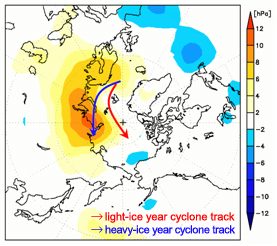
A new study headed for publication in the Journal of Climate in March further extends the influence of the warming Arctic. The article by the Research Institute for Global Change’s Jun Inoue et al. contends that the storm track over the Barents and Lara Seas takes a more northerly route when sea ice there is reduced. In a positive feedback mechanism, the northward-shifted storm track pulls warm air over the Arctic Ocean. At the same time, cold air builds over Siberia and the Norwegian coast, and becomes poised to spill southward, or to the west and the east.

“Such warm Arctic and cold continental conditions are referred to as a warm-Arctic cold-Siberian (WACS) anomaly, and the WACS anomaly could be a procurer of severe weather in the downstream region,” the authors report.
As with the collective research on the warming Arctic’s influence on mid-latitude winter weather, Inoue et al. conclude that using sea-ice variability from this region of the Arctic would improve the reliability of the seasonal weather predictions in individual years.
Arctic
They Still Make Them Like They Used To
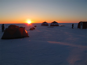
This summer, the Catlin Arctic Survey team became the first explorers to ever take ocean water samples at the North Pole. The three-person team covered 500 miles over 2 1/2 months in their expedition across sea ice off the coast of Greenland. On the way they were met with numerous obstacles: a persistent southerly drift that regularly pushed them backward, strong headwinds, ice cracks opening under their tent, dangerously thin ice, and areas of open water they had to swim across.

They persisted through it all, measuring ice thickness, drilling ice cores, and collecting water samples (see the video below) and plankton data. They hope their research will provide insight into the effects of carbon dioxide on local marine life and Arctic Ocean acidification.
The heartiness of the Catlin team reminds us of the rich history of polar exploration in the name of meteorology. Historian Roger Turner of the University of Pennsylvania gave a fascinating presentation at the AMS Annual Meeting in Atlanta about the origins of the tradition, spotlighting the group of young Scandinavian meteorologists who studied under Vilhelm Bjerknes in Bergen, Norway. They were vital contributors to numerous Arctic expeditions in the 1920s.
This first wave of Bergen School meteorologists was well-suited to polar exploration, where they contributed their familiarity with the Far North conditions as well as their new understanding of upper-air dynamics. But Turner argues that their affinity for outdoors activities–particularly in the harsh conditions of the Arctic–also set them apart from others in their generation and, by implication, from the desk-bound meteorologists today.
We think those hardy meteorological pioneers of yesteryear would appreciate the intrepid scientific spirit of the Catlin team.
Charting the Course of Arctic Warmth…and Oceanography
While many parts of the country have recently been experiencing conditions that residents might call “Arctic,” the Arctic region itself has been warming since at least the early 1990s, reaching warmth unprecedented in the last century. The consequences for global climate are potentially critical―particularly if fresh water from melting ice and increased atmospheric precipitation in the Arctic slow the overturning circulation of the North Atlantic. With Arctic sea ice melting dramatically in recent years, scientists are trying to understand the influence of the warmer water that flows into the Arctic from the North Atlantic.
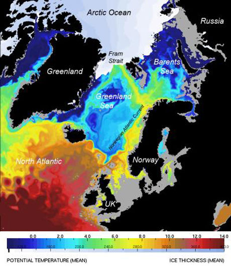
At the National Oceanography Centre (NOCS) in Southampton, United Kingdom, scientists using high-resolution computer models found that from 1989 to 2009, about 50% of the salty North Atlantic water entering the Arctic Ocean came through Fram Strait, a deep channel between Greenland and the Norwegian island of Spitsbergen that connects the Nordic Seas to the Arctic Ocean. The Barents Sea contributes about as much Atlantic water to the Arctic, but the Fram Strait water carried most of the heat that has been a primary cause of Arctic ice melting.
An example of the modeling in this study, published in the January 2010 issue of Journal of Marine Systems, can be seen in the image below, which shows a computer simulation of ocean temperatures at a depth of 100 meters and sea ice thickness in September 2006. The pathways of warm saline water toward the Arctic have previously been poorly understood, but here the 8-km resolution defines three distinct pathways for this water to move under the more pure Arctic water, thus pumping heat northward between 50 and 170 meters below the surface.
“Computers are now powerful enough to run multidecadal global simulations at high resolution,” said NOCS scientist Yevgeny Aksenov. “This helps to understand how the ocean is changing and to plan observational programs so as to make measurements at sea more efficient.”
Ocean-climate interactions are a primary focus of the ocean science research priorities recommended by the U.S. National Science and Technology Council’s Joint Subcommittee on Ocean Science and Technology (JSOST) in their 2007 report, “Charting the Course for Ocean Science in the United States for the Next Decade: An Ocean Research Priorities Plan and Implementation Strategy.” As our understanding continues to evolve regarding the ocean and its influence on the Earth system, the priorities outlined in this report have also evolved. A town hall meeting on “Refreshing Our Ocean Research Priorities” (Monday, 12:15–1:15 p.m., B212) at the upcoming AMS Annual Meeting will explore some of these developments and give participants a forum to discuss topics of interest with the chairs of JSOST.
