Stormy weather increases pain. That fact is actually good news for people suffering from chronic pain whose complaints are often dismissed by family, their friends, and even their doctors.
Speaking, and likely complaining, about the effect of weather on their pain for millennia, chronic pain sufferers finally have a large-scale scientific study to back up their claims. Its findings reveal that, at least in the United Kingdom where the research was conducted, days with higher pain levels correspond with lower pressure and its attendant adverse weather conditions, including higher humidity, precipitation and increased wind. Conversely, low pain days where fewer experience a pain event are dominated by higher pressure with weaker winds and drier air.
In “Weather Patterns Associated with Pain in Chronic-Pain Sufferers,” recently published in the Bulletin of the American Meteorological Society, author David Schultz of the University of Manchester’s Centre for Atmospheric Sciences and Centre for Crisis Studies and Mitigation, along with colleagues, detail their 15-month smartphone study, “Cloudy with a Chance of Pain.” The UK-wide initiative involved more than 10,000 participants suffering from chronic pain who used a special phone app daily to answer 10 questions about their level of pain, related symptoms, mood and physical activity, and other questions about their pain. GPS sensors in their phones enabled concurrent tracking of their location’s average weather conditions, pairing observations with their responses for analysis.
Using an epidemiological method to confine comparisons to individual participants, their research found on any given day that 16 percent of chronic-pain sufferers experience a pain event at least one level above their typical pain level, using a 5-point scale: “no pain,” “mild pain,” “moderate pain,” “severe pain,” and “very severe pain.” This increased to 23 percent on high pain days, and dropped to 10 percent on low pain days. Weather patterns, they found, explain part of the changes, modulating pain in people. It remains to be determined who suffers most, but Schultz et al. have confidence in the findings of the largest and longest-term study of its kind on the weather–chronic pain relationship.
“This result confirms the anecdotal evidence from the three-quarters of those who suffer from chronic pain who say that their pain levels are related to poor weather,” Schultz says in a video he produced to discuss the topic and the study’s findings. [See below.]
He notes that because prior research had inconsistent results and disagreement over findings, reactions to their research have been mixed, with both high praise and disdain.
“It’s perhaps not surprising that the public reaction to our study is one of two things: depending on who you listen to, people either thank us for showing what they already knew and giving support to their strongly held beliefs, or they say it was a waste of time and money because they already knew that poor weather was associated with their pain.”
By the very nature of the smartphone survey, Schultz notes that participants had the opportunity to really look at their pain and the conditions accompanying it. And with evidence in hand, the opportunity now exists for scientists to move toward forecasting such conditions in tandem with people’s pain levels to provide understanding in addition to potential welcome relief.
For people who suffer from chronic pain and believe weather influences their daily pain levels, scientists including them in the study and then conclusively demonstrating this relationship on a large scale gives their suffering meaning and validates their beliefs.
“We’ve received so many emails and tweets of support from those who participated telling us how much they appreciate being able to participate in a study like this where they actually felt their contributions were valued and they were contributing to answering a scientific question that was important to them personally. And, we do value their contributions.”
 A little more than two weeks ago, Supertyphoon Goni blasted ashore in the Philippines with top sustained winds of 195 mph, becoming the strongest landfalling tropical cyclone on record. It topped STY Haiyan’s 190 mph land strike just seven years ago. With Hurricane Iota in the Caribbean explosively intensifying 100 mph in under 24 hours to reach Category 5 intensity Monday, it set a new record of five consecutive years of Cat 5 hurricanes in the North Atlantic tropical cyclone basin. Among the seven catastrophic hurricanes, starting with Matthew in 2016, were Dorian and Irma, packing 185 mph and 180 mph steady winds, respectively, with peak gusts well over 200 mph.
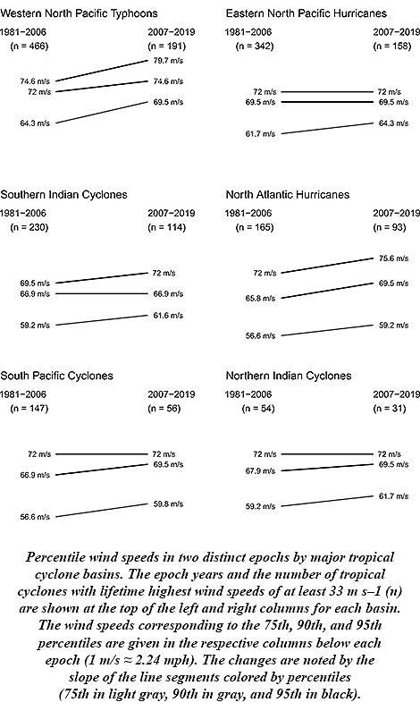 James Elsner of Florida State University says this is to be expected. His research stated in 2008 that there was an upward trend in the intensity of the most intense tropical cyclones. Rising ocean temperatures, as theory predicted, were driving the trend. And with oceans continuing to warm along with Earth’s climate since then, Elsner anticipated the continuing upward trend.
 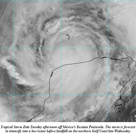 Zeta blossomed into the 11th hurricane of this hyperactive season Monday and its forecast track takes it ashore on the Gulf Coast by midweek. The National Hurricane Center (NHC) on Monday said computer models had become more tightly clustered with the forecast in the Gulf, “resulting in an increase in track-forecast confidence,” and Hurricane Zeta is expected to become the United States’ record 11th storm landfall in a single season.
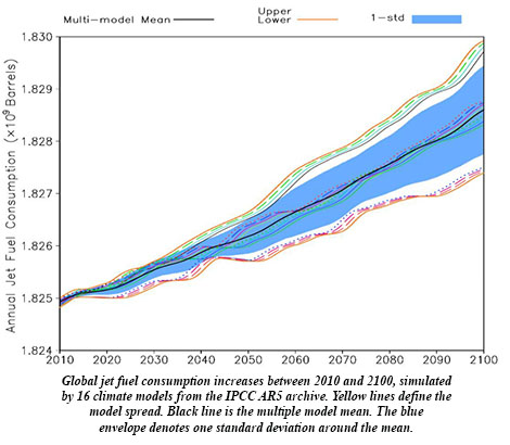 Ren et al. use an ensemble of 34 climate models to project that aviation fuel requirements by the end of the century could be an extra 160 million gallons per year due to viscosity, approaching an extra $1 billion per year in costs more than today in a scenario in which fossil fuel use is basically unabated.
 BAMS: How did you get into this focus on improving operational hurricane forecasts with unmanned aircraft?
 BAMS: What’s next? How will you follow up?