The 43rd Conference on Broadcast Meteorology and the Third Conference on Weather Warnings and Communication kicked off on Tuesday in the Raleigh Convention Center, attracting about 230 attendees. This annual meeting of meteorologists, social scientists, and other practitioners produced some exciting content and conference firsts.
Some of the AMS Communications Department staff sat down with presenters to talk about their research and presentations.
More videos with experts can be viewed on the AMS YouTube channel.
For the first time at an AMS conference there was a live stream of a panel discussion. Marking the 10th anniversary of Hurricane Katrina, a panel of experts took part in the conversation about the deadly storm and how we can learn from it going forward.
If you missed it live, you can watch the video here. We did experience visual technical difficulties twenty minutes in but the video recovers at minute thirty.
Twitter Abuzz during Extreme Precipitation Hangout
Last week’s Google hangout on extreme precipitation touched on a number of different topics related to preparing for extreme weather events and the larger goal of building a Weather-Ready Nation. It’s noteworthy that one of the key themes that recurred throughout the hangout was “communication,” as a healthy discussion was evident on Twitter during the event. We’ve captured some of the highlights here, just below the full video of the hangout.
While @NWSWPC collaborates with local NWS offices, the local office actually ISSUES the flash flood warnings you receive #ExtremeWx
— NWS Memphis (@NWSMemphis) May 1, 2015
Local forecast office is where rubber meets the road–D. Novak #ExtremeWx
— AMS (@ametsoc) May 1, 2015
Talking impacts with Dave Novak: Forecasting “local aspects and local features”of precipitation is important. #ExtremeWx @ametsoc @nwas
— Jen Henderson (@jenjhenderson) May 1, 2015
@USWeatherExpert says we need to consider decision makers schedules when issuing warnings/forecasts. #ExtremeWx
— Susan (@CommDocPA) May 1, 2015
@DrShepherd2013 says we need to better represent landscape / topography in our forecast / warning process. @ametsoc @nwas #ExtremeWx
— Jen Henderson (@jenjhenderson) May 1, 2015
Urban floods ruin cars, cost families and insurance companies $$$$, and it’s happened multiple times recently in Miami #ExtremeWx
— AAS (@astrosociety) May 1, 2015
We live in an urbanized society. When you have an urban rain event, people are feeling that–@DrShepherd2013 #ExtremeWx
— AMS (@ametsoc) May 1, 2015
David Novak talking about understanding uncertainty of extreme events – a challenge partially met by technological advances #ExtremeWx
— Susan (@CommDocPA) May 1, 2015
Someone at @NWS said uncertainty! Woo hoo! #ExtremeWx
— Jared Rennie (@jjrennie) May 1, 2015
the technical side – better remote sensing + dual pol radar + evolving science will lead to better and more specific forecasts #ExtremeWx
— Taylor Trogdon (@TTrogdon) May 1, 2015
“Satellite systems are vital for giving a large-scale view of precipitation.” —@DrShepherd2013 #ExtremeWx
— NOAA Satellites (@NOAASatellites) May 1, 2015
GOES-R, launching in 2016, will provide 1 to 5 minute imagery across the contiguous U.S. -David Novak @NWS #ExtremeWX pic.twitter.com/JyQkpWI4XR
— NOAA Satellites (@NOAASatellites) May 1, 2015
An operational ensemble of very high-res mesoscale models will help understand & forecast #ExtremeWx, both rain and snow! #WRF #petaflops
— Sara Ganetis (@SaraGanetis) May 1, 2015
Very cool insight into #ExtremeWx events. Predicting precipitation is truly a science! Have to respect forecasters! https://t.co/mxY3FQQuUy
— Leticia Ebb (@lme_mktg) May 1, 2015
.@NWSWPC‘s David Novak: New National Water Center is example of exciting partnership between NWS and other federal partners #ExtremeWx
— NWS (@NWS) May 1, 2015
John Morales taking note of the interdependence among academia, private, and public wings of the wx enterprise. #ExtremeWx
— Susan (@CommDocPA) May 1, 2015
An important aspect to remember w regard to #ExtremeWx – it’s a team effort between many orgs to build a Weather-Ready Nation @PrepareAthon
— Taylor Trogdon (@TTrogdon) May 1, 2015
.@NWSWPC Director David Novak: We need to communicate in a way that motivates people to respond and react to hazardous weather #ExtremeWx
— NWS (@NWS) May 1, 2015
People perk up when they hear “tornado/hurricane warning”, but “flood warning” doesn’t have the same effect–@DrShepherd2013 #ExtremeWx
— AMS (@ametsoc) May 1, 2015
We cannot forget that the communication of info on #ExtremeWx to the end-user is as important as the science behind it.
— Taylor Trogdon (@TTrogdon) May 1, 2015
Did someone say social sciences? We need multiple disciplines to address these issues & improve the process. #ExtremeWx @NWSWPC
— Jen Henderson (@jenjhenderson) May 1, 2015
.@CampGwen says “Preparing for disaster events need to be local. Know the hazards that impact your area.” #ExtremeWx #PrepareAthon
— Citizen Corps (@Citizen_Corps) May 1, 2015
Gwen Camp @fema: Sign up for local alerts & warnings via cell phone is greatest action to take to prepare yourself for hazards. #ExtremeWx
— Jen Henderson (@jenjhenderson) May 1, 2015
Before disaster: “Know what hazards will impact your area and how your family or business will respond.” @CampGwen #ExtremeWx #PrepareAthon
— PrepareAthon (@PrepareAthon) May 1, 2015
Gwen Camp @fema: How to prepare? Know in each season when peak hazards might occur. What will you need? Then plan. #ExtremeWx #PrepareAthon
— Jen Henderson (@jenjhenderson) May 1, 2015
Good stuff. #ExtremeWx
— Jamie Beadle (@jbeadle3) May 1, 2015
Real-Time User Satellite Data: Partly to Mostly Available
By the AMS Committee on Satellite Meteorology, Oceanography, and Climatology
Accurate forecasting and creation of weather products require large amounts of input data. Satellite data and imagery provide a large percentage of that time-critical information, including the basis of timely warnings of tornadoes and hurricanes, solar storm-induced electric currents, and the spread and concentration of volcanic ash clouds.
But the role of satellites in saving lives and preventing havoc from atmospheric events is not limited to originating essential data and imagery. Satellites make possible reliable and continuous transmission of data to the meteorologists who issue warnings, watches, and forecasts. For example, warning and water-management data from remotely located, geographically diverse terrestrial sensors in streams, rivers, lakes, and coastal areas are transmitted via the GOES Data Collection System. Thanks to satellites, these data get to first-responders and disaster managers anywhere in the country via the Emergency Managers Weather Information Network (EMWIN).
Many government agencies and the private sector have partnered on an NWS initiative called “StormReady®,” which requires multiple methods—including satellite transmissions—to receive NWS and hydrometeorological monitoring of data. Rapid and reliable communications leading to life- and property‐saving responses have never been better.
Unfortunately, the improvements made by the NWS StormReady® initiative may be threatened by recent and future radio‐frequency spectrum auctions prompted by the growing demand to share federal spectrum. Sharing between commercial broadband and sensitive satellite ground stations may be a source of radio frequency interference, which will disrupt weather product dissemination. For the first time, there is a real threat of these warnings not being received by first-responders because of potential interference caused by commercial broadband providers who will now share the same bands as StormReady® participants.
Private sector and federal users receive the imagery and science data from GOES/GOES-R satellites to guarantee data availability with rapid receipt time. If terrestrial infrastructure is degraded, the direct broadcast guarantees continuation of data.
As AMS Fellow Michael Steinburg put it at a recent webinar (see link at the end of this post): “On the one hand . . . we recognize the continued need to evaluate and optimize federal radio spectrum assignments and allocations as consumer electronics, mobile technology, and the Internet of Things experience explosive growth–sector growth that in fact results in significant growth for America’s weather industry, as new devices and platforms arise all over the world. On the other hand . . . this growth cannot put in jeopardy the core delivery methods that are used by governments and America’s weather industry to reliably collect, aggregate, and deliver foundational weather data because what those do is they provide mission-critical, lifesaving weather products. We cannot–as a Weather Enterprise united in our common goals of saving lives and improving the quality of lives for the world’s citizens–allow this to occur.”
The products developed from these satellites lead to the answers for the following questions:
- “How many miles of coastal population should we evacuate ahead of landfall for a tropical storm or hurricane?”
- “When does a severe storm forecast need to alter operations for the energy production or generation industry in a region under imminent threat for severe weather?”
- “How does a mariner obtain the best possible data to enable ocean freight to safely arrive at our ports?”
- “At what point do volcanic ash clouds, severe turbulence, or near-Earth radiation demand changes in the heading, altitude, and direction of a commercial or private aircraft to protect the safety of passengers and crew?”
Based on the results of the recent auction, which generated more than $40 billion in revenue, the temptation of government officials to focus more exclusively on the enormous revenue these auctions can create will be great. We, who provide the American people with reliable and accurate weather forecasting and warnings, along with the state and local disaster managers who rely on this information, must make our voices heard.
We urge you to be vigilant as recommendations are made for radio spectrum auctions, which may be shared between the nation’s weather satellites and commercial use. Your input to the Federal Communications Commission on the importance of meteorological products to industry segments will be necessary in the next few months to communicate the importance this spectrum plays in weather forecasting. Comments to the FCC Office of Engineering and Technology can be directed to [email protected].
Two recent AMS-sponsored events discuss this situation in considerable detail. See https://ams.confex.com/ams/95Annual/webprogram/Session37898.html and http://swfound.org/events/2015/challenges-in-sharing-weather-satellite-spectrum-with-terrestrial-networks/.
AMS Washington Forum: Unleashing Big Data and Big Discussion
Today at her keynote address to the AMS Washington Forum, U.S. Secretary of Commerce Penny Pritzker announced that NOAA is forming five new alliances to help bring its vast data resources to the public. The partnerships with Amazon Web Services, Microsoft Azure, IBM, Google, and the Open Cloud Consortium address the growing need for access to NOAA’s huge—and rapidly growing—environmental data resource.
That Secretary Pritzker’s announcement came at the opening of this year’s Forum is a testament to the sustained focus of these annual AMS gatherings in Washington, D.C. The Forum revisits recurring themes to build year-to-year unity—and progress—to the discussions. Last year, for example, the AMS Washington Forum participants focused on how data integration across disciplines and sectors drives the effectiveness of the weather, water, and climate enterprise. The Forum found that
Working across agencies and across sectors (e.g., health, energy) is becoming a new “normal” for solving problems. All agree the needs and demands for data, information and forecasts are continuing to change, so our enterprise must remain flexible and agile.
Though the context last year was more about the use of commercially provided data, this continuing Forum theme resonates with Secretary Pritzker’s announcement today. The new government-private sector partnerships are part of the overall movement toward “open government”–accessible, consistent data practices—that should enhance the flexibility and agility emphasized at the AMS Forum last year.
Forum participants also generally agreed last year that “while the private sector needs to take on a bigger role in the provision of weather data, the public and private sectors need more time to jointly determine the best path forward.” And indeed at that time NOAA was in an information-gathering phase preparing for the partnerships announced today. The agency issued a Request for Information (RFI) in February 2014 to see who might be able to help move NOAA data onto the cloud. Commercial partnerships would, according to the RFI, help pull together disparate NOAA sources and web sites and help people “find and integrate data from these sources for cross-domain analysis and decision-making.”
Data integration was not the only motivation. Being the main provider of its own data saddles government agencies with burgeoning information technology needs.
In a separate email news letter today, NOAA Administrator Kathryn Sullivan elaborated on the scope of the Big Data need:
Of the 20 terabytes of data NOAA gathers each day — twice the data of the entire printed collection of the United States Library of Congress — only a small percentage is easily accessible to the public.
The cloud was a way to alleviate this situation, as the RFI stated:
NOAA anticipates these partnerships will have the ability to rapidly scale and surge; thus, removing government infrastructure as a bottleneck to the pace of American innovation and enabling new value-added services and unimaginable integration into our daily lives.
Private sector cloud services have a history of meeting such challenges. The cloud services are able not only to store the huge quantities of data NOAA produces each day but also to provide opportunities for cloud-based applications. This means information processing is possible remotely so that each user does not need to have his or her own advanced infrastructure to move and manipulate vast troves of data. Thus, working in parallel with traditional NOAA data distribution channels, cloud services are expected to enable widespread use of Big Data and to drive private-sector development of applications.
The continued AMS discussions here in D.C. over Wednesday and Thursday will further amplify such continuing themes as Big Data, providing an especially rewarding venue for participants who can return year after year to the Forum. For example sessions tomorrow on “Rail and Trucking” and “Information Needs for Water Related Extremes” hinge in part on data dissemination. Surface transportation was one of the panel topics last year, as well, meaning repeat participants this year will have an opportunity to update their earlier impressions and find out how opportunities in that field are progressing.
By reaching out to the innovators of the cloud, NOAA stated it was
looking for partners to incite creative uses and innovative approaches that will tap the full potential of its data, spur economic growth, help more entrepreneurs launch businesses, and to create new jobs.
That’s pretty much the same reason leaders of the weather, water, and climate enterprise return year after year to the AMS Washington Forum.
Hanging Out with Women in Weather
Today’s Google hangout on “Women in Weather,” cohosted by AMS and the American Astronautical Society and presented by Northrop Grumman, featured an insightful and wide-ranging discussion about what it means to be a woman in the atmospheric sciences. But the conversation wasn’t just among the panelists–it was also active on Twitter. If you missed the live broadcast of the hangout, you can watch it below, and check out the sampling of tweets underneath the video.
Google Hangout starting now about role of women in weather. We need more of this. http://t.co/unYaV5W8z9 #ExtremeWx @ametsoc
— Bill Gail (@wbgail) March 25, 2015
Love all the girl power! Great group!! #ExtremeWx #LikeAGirl
— Samantha Davies (@SDaviesNBC5) March 25, 2015
.@NWS's Courtney Draggon: We need more social scientists to help build a Weather-Ready Nation http://t.co/DZ0hkl0ySJ #ExtremeWx #LikeAGirl
— NWS (@NWS) March 25, 2015
As if I didn't have enough of an issue figuring out what I want to do when I graduate, they drop "social scientist" #likeagirl #ExtremeWx
— Rochelle Ball (@DenverRochelle) March 25, 2015
Wow wish I could have gone storm chasing as part of my degree like @Ginger_Zee – learning from a book isn't everything #ExtremeWx
— Sally Webb (@WeatherWebb) March 25, 2015
@Ginger_Zee always re-inspires me in pursuing this very challenging second degree. #gonnagetthatseal #extremewx #meteorologistinthemaking
— Star Derry (@StarDerryWX) March 25, 2015
.@NWS's Robyn Heffernan: For IMETs observations are everything; remote sensing is very valuable http://t.co/DZ0hkl0ySJ #ExtremeWx #LikeAGirl
— NWS (@NWS) March 25, 2015
Robyn H – female IMETs are up to 14% in the field compared to 7% not long ago. Let's encourage more female IMETs #LikeAGirl #ExtremeWx
— Christine Shifa (@steneriley) March 25, 2015
Love our IMETS! At one point, that was my career goal. Now I get the best of fire wx and outreach/education! #Extremewx #likeagirl
— Tanja Fransen (@mtwxgirl) March 25, 2015
A. @NWS Wx is affected by global system so cooperating internationally is fundamental to NWS's mission. It's a two-way street. #ExtremeWx
— AMS (@ametsoc) March 25, 2015
.@twcMariaLaRosa – As a broadcast meteorologist, have to constantly be aware of our messaging on social, make sure clear/concise #ExtremeWX
— The Weather Channel (@weatherchannel) March 25, 2015
It's always interesting to hear from Mets outside of the tv business – there's so much more to meteo but all are important. #ExtremeWx
— Rachael Peart (@RachaelJPeart) March 25, 2015
'Female meteorologists on TV are not treated as scientists; they are treated like dolls' #WomenInWeather #ExtremeWx
— Amanda Lindquist (@AmandaKMOT) March 25, 2015
@Ginger_Zee : "The misunderstanding of what a meteorologist is is our #1 problem." PREACH. #ExtremeWx
— Courtney Obergfell (@ceober4) March 25, 2015
A. @RebeccaMillerWX Women on tv treated much differently than men, makes it hard to get the message to the public. #ExtremeWx
— AMS (@ametsoc) March 25, 2015
Seeing successful women in the field I would love to be a part of is inspiring, so thank you. This means a lot to me. #ExtremeWx #LikeAGirl
— Jennifer Naillon (@jsnaillon) March 25, 2015
A. @Ginger_Zee Huge goal is get rid of "weather-girl" term. #ExtremeWx #LikeAGirl
— AMS (@ametsoc) March 25, 2015
Advice: "don't be afraid to ask for help" … "and once you get that job help others coming behind you" #ExtremeWx #LikeAGirl
— Rosimar Rios-Berrios (@RosimarWx) March 25, 2015
.@NWS's Robyn Heffernan: Don't be intimidated by math and science. You can do it! http://t.co/DZ0hkl0ySJ #ExtremeWx #LikeAGirl
— NWS (@NWS) March 25, 2015
#ExtremeWx and #LikeAGirl hashtags now trending on @twitter! 🙂
— Rosimar Rios-Berrios (@RosimarWx) March 25, 2015
Yes. This. RT @ametsoc: A. @NWS Don't worry what people think, do you you want to do and have a passion for. #ExtremeWx #LikeAGirl
— morganabigail (@morganabigail) March 25, 2015
Seriously. What an inspirational hangout! My dreams got so much bigger over the last hour. #LikeAGirl #ExtremeWx
— Rochelle Ball (@DenverRochelle) March 25, 2015
A Year Ago in Oso: Wrong Place at the Wrong Time
At 10:36 a.m. on 22 March 2014, near Oso, Washington, the earth began to move. At first the lower section of slope rising from the North Fork Stillaguamish River slipped. Then the rise above that collapsed, ultimately sliding so fast that nothing could stand in its way. An eyewitness near the river saw water tossed aside and turn black. A 30 m high wall of turbulent earth roared across and along the valley. About 8 million cubic meters of dirt and rock buried the village of Steelhead Haven and killed 43 people. The slide ultimately dammed the river as it raced at 60 km/h along a 1 km wide, 1 km long swath. 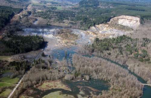
The Oso landslide (aftermath photo above, Mark Reid/USGS) was a scientific mystery. There was no obvious geological trigger, like an earthquake. And the slope itself, while prone to slides, was not precariously steep. Meteorologically, it was a rain-free day in a week of no precipitation. However, two new studies—one of them forthcoming soon in the Journal of Hydrometeorology—show why Steelhead Haven was in the wrong place at the wrong time, both geologically and meteorologically.
An overview paper this January in Earth and Planetary Science Letters showed how the Oso landslide underwent two stages of motion. The lower slope slipped slowly for about 50 seconds until the more radical collapse from above led to a high mobility liquid state called a “debris avalanche.” As the landslide spread across the river the debris picked up more moisture. The flow of dirt and rock spread the damage far beyond the initial slip of earth. The gushing mud and rock actually splashed against the opposite slope across the river and spread back upslope on top of itself.
Previous landslides in the Oso area had never attained that extremely mobile second stage. The slope of the 180 m high rise above the river is less than 20 degrees, and scientists have found highly mobile landslides usually start with greater than 20 degree slope—typically more than 30 degrees. What made this one different?
The paper’s authors, Iverson et al. say one reason was the porous geology of local sediments and silt. This porosity may have increased suddenly as the base of the slope started to slip. Then as ground slid the pores contract, raising water pressure and increasing liquefaction that greases the skids for faster movement and more contraction. Furthermore, as rock and dirt overran the river, the slide picked up another 50,000 cubic meters of water and scoured the river bed for more debris.
But if a critical sensitivity to initial geological conditions existed why did the land give way on a sunny day like 22 March 2014 instead of during an earlier, rainier part of the season?
The analysis by Brian Henn et al. in Journal of Hydrometeorology shows that the precipitation in the three weeks before the landslide was unexceptional (such periods are expected every two years or so) if compared to the soaking that the area can get during the rainy season. But the rain was exceptional (an 88-year expected return period) when compared to similar March periods of the past, and that is a bad time to get wet.
Since March is late for the rainy season, this meant additional water charged deep soils that were already wet. Heavy rains earlier in the year encountered soils that contained less moisture. The late rains came on top of an already wet season as well as four wet years before that.
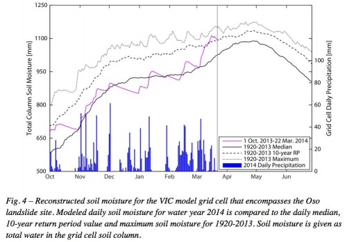
As a result, six days before the landslide soil moisture for the water year peaked and was wetter than would be expected every 40 years at that date. The soil moisture had surged beyond median levels in just a few weeks. [See figure above from Henn et al. 2015]
In other words, Oso was primed for a landslide, even on a dry day, partly because some of the rain had fallen late in the season—poor meteorological timing for the village of Steelhead Haven.
From Florida, A Reminder About Freedom of Expression
The Florida Center for Investigative Reporting published allegations this week that the terms “climate change” and “global warming” were banned from state government communications in Florida, including state-agency sponsored research studies and educational programs. The Washington Post followed with claims, for example, that a researcher was required by state officials to strike such words before submitting for publication a manuscript about a epidemiological study.
No evidence of a written policy or rule has been reported, and state officials have denied any policy of the sort. Meanwhile, the media are hunting through Florida websites trying to find state documents produced during the administration of Gov. Rick Scott with contents that would contradict the charges of an unwritten policy, imperfectly enforced.
The controversy is one in a string of recent events reminding us how much scientists rely on their freedom of expression. Most often the problem has been the freedom of government scientists to speak about their work with the public. Lately this has caused a media blizzard in Canada.
Science ethicists may argue one way or another about where the limits of public expression are for government scientists when they contradict policy goals. And certainly—as well seen most obviously in the Cold War—such goals can include national security concerns. But the AMS stance on the filtering or tampering of science for nonscientific purposes is quite clear in the Statement on Freedom of Expression:
The ability of scientists to present their findings to the scientific community, policy makers, the media, and the public without censorship, intimidation, or political interference is imperative.
Freedom of expression is essential to scientific progress. Open debate is a necessary part of science and takes place largely through the publication of credible studies vetted in peer review. Publication is thus founded on the need for freedom of expression, and it is in turn a manifestation of freedom of expression.
One might think the job of journals is to screen out unwanted science, but it’s quite the opposite. Papers are published not because they are validated as “right” so much as they are considered “worthy” of further scientific consideration. In addition, the publication process itself—which AMS knows well in its 11 scientific journals—is not just for authors to report and interpret their work. It relies on free discussion. The peer review process usually allows reviewers maximum protection of anonymity to preserve the ability to speak freely about the manuscripts being scrutinized. The papers that pass review are then the starting point for documenting objections, alternative interpretations, and confirmation, among other expressions that only matter if made accessible to other scientists through peer reviewed journals.
The AMS Statement recognizes that such freedom implies responsibility:
It is incumbent upon scientists to communicate their findings in ways that portray their results and the results of others, objectively, professionally, and without sensationalizing or politicizing the associated impacts.
Scientists are not the only ones to treasure such freedoms, of course. Society benefits from the progress of science every day. This only happens when scientists freely, promptly, and prolifically report what they find—and that means exactly what they find, not what they are told to find. The alternative is to compromise the pursuit of truth and the very foundations of our health and prosperity.
We all become victims when science is not shared and cannot flourish. The fact that climate change has deep social, economic, and political implications today means it is even more important to recognize that with increasing value of climate change science comes the increasing temptation for policy makers to co-opt and alter that science. As the AMS Statement warns, the principles of free expression “matter most—and at the same time are most vulnerable to violation—precisely when science has its greatest bearing on society.”
For Data to Live Long and Prosper
On February 25, the AMS released its new policy on citations for data sources in journal articles. We were all set to tell authors about it when sadly, far bigger news stole the attention of scientists everywhere. The great creator of Spock, actor Leonard Nimoy, had died. Within two days, the story of data policy had become the story of Star Trek.
“That’s not logical,” you say.
OK, we’re not Vulcan, but even a human can see this. Data. Spock. Now is the time to bring them together.
Nimoy made an improbable—some would say illogically great—impact on society masquerading as a half-Vulcan, half-human creature named Spock hurtling through space on both the small and big screens. The tributes following Nimoy’s death last week have spoken of his ability to transcend the seeming limitations of such a curious role. Nimoy embodied racial ambiguity in a time of prejudice, ennobled diplomacy and rationality in an age of war, and gave voice to those who feel alien in their own neighborhoods and schools.
Of all the dualities in Spock’s character—so brilliantly portrayed by an immigrant’s son who skipped college—arguably the most explicit was as the science officer on bridge of the “Enterprise.” His struggle to remain true to the Vulcan creed of logic without emotion was a perfect expression of science in its time. For nerds of the 1960s and ‘70s, Spock’s reliance on logic echoed the haughty aloofness with which popular culture characterized scientists of the Cold War. But through his formidable devotion to knowledge, truth, and teamwork—working through all the pointy-eared social awkwardness he faced among his crew-mates– Spock somehow made science a new kind of “cool” long before geeks made billions of bucks with computers.
The thing is, scientists are a duality, much as Spock and Captain Kirk were two sides of a coin. They get emotional about two things. One is logic. Scientists, like mathematicians, get dewy-eyed about beautiful theories, elegant proofs, and ingenious solutions. The other is data. Unlike Spock, they work themselves into a frenzy over data. The best way to make scientists swoon is to produce data that reveal secrets.
For science to live long and prosper, that data need to be treasured like a home planet. For a long time, most scientific publishers thought it was good enough that journal authors would casually mention data archives in their Acknowledgments. In this age of computer models and constantly updating technology, that’s not good enough. Now authors must use carefully sourced and dated formal citations and references that in turn lead to safeguarded, easily accessible repositories. The author’s guide online gives some helpful examples.
The new citation policy is just one step of many advancing data archive practices that were recommended in the AMS Statement on Full and Open Exchange of Data adopted in December 2013. That statement also calls on funding agencies to recognize the costs of managing data. It recognizes that data preservation and stewardship should be emphasized and discussed at meetings. It says AMS should promote conventions and standards for metadata to increase interoperability and usage, and that the Society should foster ways of deciding what data should be kept to improve preservation practices in the future.
AMS is not alone in this shift. There are others in the chain of research, publication, and archiving trying to do for data what Spock did for logic. Our Society is one of the original members of a year-old team of publishers, data facilities, and consortia called the Coalition on Publishing Data in the Earth and Space Sciences. COPDESS is working to ensure that data are preserved through proper, secure funding, and that careful decisions are made about what should be saved.
Most importantly, this international movement toward protecting and providing data is meant to preserve the scientific process. Science needs published studies to lead to more studies that can confirm or reject findings. According to the AMS Statement,
AMS should strongly encourage an environment in which scholarly papers published in scientific journals contain sufficient detail and references to data and methodology to permit others to test each paper’s scientific conclusions.
All that depends on data being available in the review process as well as in perpetuity, with published results closely aligned with open archives.
Logic and Data: the duality of the scientific spirit. It is easy to celebrate one without the other, but it would not be proper. Spock would understand.
Dual Pol Radar Shedding Light on "Wintry Mix"
A recent article in the New Yorker tried in vain to dissect and understand the term “wintry mix,” only to grimly report it’s a weather phenomenon vile and disgusting and that forecasters state it to cover their backsides when a variety of winter precipitation is to descend upon man.
Far from vile and disgusting, a wintry mix is just that: a mixture of winter precipitation—snow, sleet, freezing rain—falling from the sky. No more, no less. Its mention will return to forecasts this weekend as a moisture-laden storm in the nation’s midsection plows into Arctic air and treks across the inland South and into the East next week. Rest assured: research and new technology are ready and are allowing forecasters to view wintry mix in amazing detail, better than ever before, improving predictions of the phenomena by leaps and bounds.
Recently published research on dual polarization (dual pol) weather radar in use, in a handful of AMS journals, is shining a spotlight on its capability to determine different types of precipitation falling at the same time, including the once-dreaded wintry mix. Instead of shying away from such forecasts, meteorologists using the nation’s network of Doppler radars, upgraded in recent years to include polarimetric technology, are beginning to get really good at chronicling the wintry mix in their forecasts.
While the New Yorker implied meteorologists disdain for the term, wintry mix actually is looking more beautiful than ever to scientists–so nice we put the words on the cover of the latest BAMS: “Snow Globe: Dual Pol Deciphers Wintry Mix.”
This cover article in BAMS, by Picca et al., looks at New England’s monster blizzard of 9 February 2013, which unloaded more than 3 feet of snow on much of central Connecticut and Long Island. Dual pol radar’s unique modes deciphered the wintry mix inside an intense snowband producing lightning and snowfall rates of 3-6 inches per hour.
A similar article in Weather and Forecasting, by Griffin et al., documents for the first time polarimetric radar signatures of the same intense convective band of snow. The transition zone from freezing to non-freezing air (0°C isotherm) was exceptionally distinct in the radar signatures.
In the Journal of Applied Meteorology and Climatology (JAMC), the article by Kumjian et al. discusses the use of intensive radar measurements to study the finescale structure of more than a dozen Colorado Front Range snowstorms. And in Monthly Weather Review, Geerts et al. explain in their article how a specifically synthesized dual Doppler radar technique in an airborne platform was able to directly measure hydrometeor vertical motion, improving the accuracy of the radar.
An Invitation to the AMS Washington Forum
By Shawn Miller, Chair, AMS Board on Enterprise Economic Development
Fellow stakeholders in the weather, water, and climate enterprise, as chair of the AMS Board on Enterprise Economic Development (BEED), I would like to invite you to participate in the 2015 AMS Washington Forum, April 21-23 at the American Association for the Advancement of Science (AAAS) Building, 1200 New York Avenue NW in Washington, D.C.
Organized by the AMS BEED, the purpose of the annual AMS Washington Forum is to provide an opportunity for members of the weather, water, and climate community to meet with senior federal agency officials, congressional staff, and other community members to hear about the status of current programs, learn about new initiatives, discuss issues of interest to our community, identify business opportunities, and speak out about data and other needs.
The 2015 AMS Washington Forum will focus on end users of weather, water, and climate data, returning to the theme of past years’ User Forum events conducted by the AMS. As the enterprise evolves and adapts to changes in budgets and cost-sharing paradigms, heightened attention to the needs of its end users is key to success for all stakeholders. Particular attention must be given to key areas of industry, such as health and the various modes of transportation. The 2015 forum will promote dialogue between the enterprise and its end users toward that end. Several special topics are planned for interactive panel discussions, including an overarching theme session; hospital preparedness in the wake of extreme weather and climate events; weather data needs relating to rail, trucking, and marine transportation; and water resources and related user needs. The forum will also feature speakers on the topics of national/international water rights issues, the intersection between legal and science issues, and commercial weather satellites. Complementary to the session topics on specific user needs, senior leaders from agencies including NOAA, NASA, and other enterprise stakeholders will look ahead and provide updates on current programs and provide insights on new science initiatives and directions. We will also invite leaders from the Office of Management & Budget and the Office of Science & Technology Policy, and from Congress, who will discuss the latest weather-, water- and climate-related programs and legislative initiatives to better serve the American people.
Seating is limited for this exciting event, so preregistration is strongly recommended. Please watch the AMS_PSL list for announcements, or send an e-mail to Gary Rasmussen ([email protected]) to be added to the announcement list. Thank you for your time and attention, and I hope to see you in Washington this April!