The Atmospheric Science Librarians International (ASLI) announced their ASLI Choice Award winners for 2012 on Wednesday afternoon at the ASLI exhibit. The awards, now in their eighth year, are presented for the best books of the year in the atmospheric sciences and are judged in the following criteria: uniqueness, comprehensiveness, usefulness, quality, authoritativeness, organization, illustrations/diagrams, competition, and references.
Awards were given in four categories: science, history, popular, and reference (a new category this year), and in one case a series was honored rather than a book. The winners by category are:
Science
The Future of the World’s Climate (Second Edition), edited by Ann Henderson-Sellers and Kendal McGuffie, published by Elsevier, 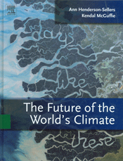 chosen for “the broad scientific context that it provides for current efforts to model and predict climate change.”
Honorable mention–Atmospheric Physics: Background–Methods–Trends, edited by Ulrich Schumann, published by Springer, for its “up-to-date essays on facets of the atmosphere, the methods and instruments used to conduct research in the field, and upcoming research trends.”
History
Hawai’i’s Mauna Loa Observatory: Fifty Years of Monitoring the Atmosphere, by Forrest M. Mims III, published by the University of Hawai’i Press, 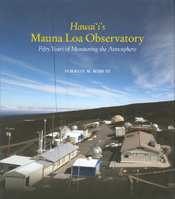 for “its engaging perspective on the scientists, discoveries, and ground-breaking atmospheric measurements done at Mauna Loa Observatory.”
Honorable mentions–Lake Effect: Tales of Large Lakes, Arctic Winds, and Recurrent Snows, by Mark Monmonier, published by Syracuse University Press, for “its clear and accessible examination of lake-effect snow, a regionally important meteorological phenomenon, and how it has shaped the history of the Great Lakes region”; History of the Meteorological Office, by Malcolm Walker, published by Cambridge University Press, for “a thorough account of the scientists, science, and achievements of the Met Office from its earliest beginnings to the present day”; and The Discovery of Weather: Stephen Saxby, the Tumultuous Birth of Weather Forecasting, and Saxby’s Gale of 1869, by Jerry Lockett, published by Formac Publishing, for “a readable history of the evolution of weather forecasting, the Gale of 1869, and Saxby’s prediction of the storm.”
Reference
The Atmospheric Chemist’s Companion: Numerical Data for Use in the Atmospheric Sciences, by Peter Warneck and Jonathan Williams, 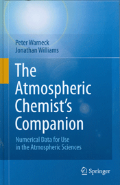 published by Springer, for “its well-organized assembly of frequently needed numerical data and measurement techniques.”
Honorable mention–Kinikmi Sigum Qanuq Ilitaavut–Wales Inupiaq Sea Ice Dictionary, compiled by Winton Weyapuk Jr. and Igor Krupnik, edited by Igor Krupnik, Herbert Anungazuk, and Matthew Druckenmiller, published by the Smithsonian Institution, for “preserving, documenting, and illustrating the terms for sea ice and associated phenomena in the Kingikmiut dialect.”
Popular
Princeton Primers in Climate series, edited by Alison Kalett, published by Princeton University Press, for “for brief, readable books on key topics in climate science that provide essential knowledge and point to further investigation.”
Congratulations to all the winners! Go to the ASLI Choice Award page to find out how to nominate a book for the 2013 awards.
Uncategorized
Scenes from the Annual and Austin
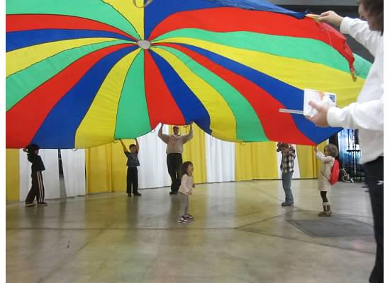
The meeting may still be in full swing but it’s not too early to take a look back at some highlights of the past few days. Check out AMS’s flickr page for photos of the student conference, WeatherFest, Keep Austin Beautiful, the Exhibit Hall, and attendees in action. You might even see yourself in one.
Go to flickr to see more and be sure to check back regularly for additions.
More Green for Authors Who Use Color
Good news for authors publishing in AMS journals: starting in April, there will be no extra charges for full-color figures. The change was announced at the Annual Meeting on Monday.
According to Director of Publications Ken Heideman, bringing these costs down to zero has been a major goal since 2005, when it was first proposed by Dave Jorgensen, the outgoing Publications Commissioner.
“We all thought that that was a nice fantasy,” joked Heideman, but he noted that since then the AMS has dropped the prices for color figures several times. “Now we’re using efficiencies and savings in other areas to help subsidize what is the final reduction to zero.”
In the past, several authors had suggested printing figures in black and white but having them in color online, referred to as divergence of content, which is not allowed by the AMS Publications Commission.
“Our print is exactly what is online, including color, and we’re proud of that,” said Heideman.
He also noted that lower overall costs could be a long-term investment in the organization.
“Having zero color charges for full-paying authors will increase submissions, and that’s a positive reinforcement cycle.”
[UPDATE 1/9/13: Note that the new charges apply to articles that are submitted after April 1.]
TRMM Keeps on Truckin'
It’s been 15 years since the Tropical Rainfall Measuring Mission (TRMM) satellite was launched. Over that time, TRMM has significantly advanced our understanding of precipitation through measurements of the global distribution of rainfall at Earth’s surface, the global distribution of vertical profiles of precipitation, and other rainfall properties. As a result, TRMM provides clues to the workings of the water cycle and the relationship between oceans, the atmosphere, and land. But the benefits of TRMM extend beyond the research community. The image below exhibits the kind of operational data TRMM can supply: it’s a rainfall analysis of SuperStorm Sandy that reveals the heaviest rainfall totals during the storm (more than 10.2 inches) were over the open waters of the Atlantic Ocean.

Despite its advanced age, TRMM continues to provide unique data; its enduring value is evidenced by the fact that more than 50 presentations at the AMS Annual Meeting in Austin are related in some way to TRMM and its data. A few examples: Yingchun Chen of the University of Melbourne will examine TRMM’s estimates of daily rainfall in tropical cyclones using the Comprehensive Pacific Rainfall Database (PACRAIN) of 24-hour rain gauge observations (Wednesday, 9:30 a.m., Room 10b). A poster presentation by Dana Ostrenga of ADNET Systems and NASA’s Goddard Space Flight Center will review the recently released Version 7 TRMM Multi-satellite Precipitation Analysis (TMPA) products and data services (Monday, Exhibit Hall 3). Zhong Liu of George Mason University will present a poster on the TRMM Composite Climatology, a merger of selected TRMM rainfall products over both land and ocean that provides a “TRMM-best” climatological estimate (Monday, Exhibit Hall 3). In her poster, Hannah Huelsing of the National Weather Center will show how TRMM 3-hourly data were used to look at the spatial and temporal distribution of the Asian premonsoon and monsoon seasons in Pakistan during 2010’s severe flood year (Tuesday, Exhibit Hall 3).
As TRMM matures, it’s also broadening its horizons and crossing disciplines. Earth-observing systems are increasingly being utilized in the field of public health, and in Austin, the Fourth Conference on Environment and Health will include a themed joint session on this budding partnership. In that session, Benjamin Zaitchik of Johns Hopkins University will discuss the modeling of malaria risk in Peru (Monday, 5 p.m., Room 6b). Zaitchik and his colleagues modeled the influence of land cover and hydrometeorological conditions on the distribution of malaria vectors, as well as the relationship among climate, land use, and confirmed malaria case counts at regional health posts. In the study, meteorological and hydrological conditions were simulated with the use of observations from TRMM and other satellites.
Versatile VIIRS: Sandy Reveals More of Its Potential
The VIIRS instrument aboard the new Suomi National Polar-orbiting Partnership (NPP) satellite has a lot of jobs: among them, to measure cloud and aerosol properties, ocean color, sea and land surface temperature, ice motion and temperature, fires, and Earth’s albedo. Now, with the experience of Superstorm Sandy behind it, add tracking power blackouts to the list of tasks for this multifaceted instrument.
VIIRS–or more formally, Visible Infrared Imager Radiometer Suite, is a scanning radiometer that collects visible and infrared imagery and radiometric measurements of the land, atmosphere, cryosphere, and oceans. Its low-light sensor–known as the day-night band–can detect light from cities and towns in the absence of clouds. This function recently proved to be highly valuable when NASA’s Short-term Prediction Research and Transition Center used data from VIIRS to assist disaster responses agencies (including FEMA and the U.S. Army Corps of Engineers) in identifying areas that lost power during Superstorm Sandy. Composites of VIIRS images taken before and after Sandy (see below for an example) pinpointed the blackouts.
This is just one example of the promising capabilities of VIIRS; and the growing awareness of these capabilities is why VIIRS is the subject of a town hall meeting on Monday, January 7 (12:15-1:15 p.m., Room 18B) at the AMS Annual Meeting in Austin. Forecasters, meteorologists, and other end users will discuss how they are utilizing the new VIIRS datastream and the critical role it can play in weather forecasting and in improving emergency preparedness and disaster response efforts.
A number of other presentations in Austin will highlight the versatility VIIRS. Jeffrey Hawkins of the Naval Research Laboratory will take an in-depth look at VIIRS’s day-night band and efforts to create enhanced products geared toward various nowcasting applications (e.g., dust enhancement observations, smoke and volcanic ash plumes, cloud properties, tropical cyclone structure, etc.) (Wednesday, 1:30 p.m., Ballroom G). Donald Hillger of NOAA/NESDIS will compare and contrast imagery produced by VIIRS with that from other satellites (Tuesday, 11:45 a.m., Ballroom G). And Jim Biard of the Cooperative Institute for Climate and Satellites will provide details on the VIIRS Climate Raw Data Record (C-RDR), including its contents and structure, its production methods and process, and file access (Wednesday, 11:30 a.m., Ballroom G).
VIIRS is one of five instrument/sensor payloads aboard Suomi-NPP, which is the first of a new breed of satellites that will replace NASA’s Earth Observing System satellites. Launched in October of 2011, the progress and promise of Suomi-NPP and its new data applications will be explored at a town hall meeting on Tuesday (12:15-1:15 p.m.; Ballroom G).
Speaking of Superstorm Sandy, electricity outages, and town hall meetings, there are two related Town Halls of special importance Monday night at the AMS meeting: a wide-ranging meeting on the storm itself (7:30-9:30 p.m.; Ballroom E) and an exploration of the impacts of weather on the electrical grid (Monday, 6:30-8:00 p.m.; Room 14). More on this in future posts on The Front Page.

Wild Weather Comes to NCAR

A new exhibit exploring the power of weather and the stories behind it opened earlier this month at NCAR’s Mesa Lab in Boulder, Colorado. Spark, the group that oversees science education at UCAR, created the exhibit with input from scientists, engineers, designers, and writers.
“Weather is a fascinating topic and it affects us all,” comments Rajul Pandya, director of Spark. “In the new Weather Gallery, visitors can touch clouds, make forecasts, and learn how scientists understand weather using special instruments and computer simulations.”
The NCAR Weather Gallery joins existing exhibits like an eight-foot-tall tornado, a microburst generation tank, and a display that shows current wind speeds measured on top of the building. One of the new features is the interactive, “Tell Your Weather Story,” which gives visitors the opportunity to describe and post their own experiences on weather.
It took about 20 months to plan and develop the exhibit from start to finish. To begin the process, an advisory committee met to decide what topics the exhibit should cover and what they wanted visitors to experience. They came up with a plan that included five content sections and several different ways of delivering information, which included hands-on interactives, large mural photos, panels with pictures and text, and touch screens with games and videos.
Since the exhibit opened on 10 October, the Mesa Lab has had approximately 2,000 visitors, with at least half that number spending time in the exhibits. About 15,000 people a year attend scheduled programs at lab, including 10,000 K-12 students and teachers who take classes and go on tours, as well as 5,000 in special groups and public tours.
“People are really excited about the new exhibit. Visitors love all of the opportunities to play with the hands-on stuff, and it’s been fun to see groups of visitors interacting with each other as they explore different parts of the exhibit,” says Becca Hatheway, NCAR exhibit manager. “UCAR and NCAR staff members are also excited to see something new in this space. I’ve seen just as many staff spending time in the exhibits as I have seen visitors. So I guess we’re all excited to learn more about the weather.” The visitor center at the Mesa Lab is open to the public year round and offers free exhibits about weather and climate, a gallery featuring local artists, an outdoor weather trails, and more. For more information visit the Spark web site.
And speaking of Spark, today (Saturday, 27 October) is UCAR’s Super Science Saturday from 10 a.m. to 4 p.m.–a chance for the whole family to visit the labs and combine science with some Halloween fun. There’s a preview video at the Spark home page:
These Observations Get Our Stamp of Approval
The scientific benefits of Earth observation are well known in the atmospheric sciences. But there’s an artistic side to such observations, too, which is spectacularly depicted in the U.S. Postal Service’s new Earthscapes stamps, released last week in celebration of National Stamp Collecting Month and featuring images shot aloft from a variety of platforms, from a micro-light kite to satellites in space.
The set of 15 different stamps depicts natural, agricultural, and urban scenes from across the country. The Service’s contracted photo editors and researchers culled hundreds of images, which USPS Art Director Howard Paine narrowed down to the final 15. Some photos were taken by people in private planes and helicopters; others were taken by unmanned instruments, including the one below of the volcanic crater of Mount St. Helens in Washington, which was captured in 1999 by NASA’s Landsat 7. Other images in the set include ice breaking off from Alaska’s Bear Glacier, a cherry orchard in Wisconsin, and a cranberry bog in Massachusetts.
Along with the forever stamps, other Earthscapes collectibles for the philatelist include a first-day cover set, a jigsaw puzzle, and an Earthscapes ceremony program.

AMS Dedicates 45 Beacon Room to Joanne Simpson
Last week, AMS held a ceremony at our 45 Beacon Street headquarters in Boston to celebrate the life and accomplishments of pioneer scientist Joanne Simpson. The AMS Council, AMS staff, and members of Joanne’s family gathered to watch the unveiling of her portrait that hangs in what is now “The Simpson Room.” The first woman to ever receive a Ph.D. in meteorology and first female AMS president, Joanne’s numerous contributions to science and the Society were lauded by current AMS President Louis Uccellini and Past President Peggy Lemone:
One of Joanne’s daughters was in attendance and Joanne’s husband, Robert Simpson, and three other children were able to view the ceremony through video conference. Robert had this to say:
On behalf of the Simpson family at large, I want to express our deep appreciation to the Society for its special recognition of Joanne Simpson with this unique posthumous award. All of us appreciate that you chose this unique way of further honoring Joanne. She served AMS nobly and effectively throughout her career—a career distinguished not only by her seminal contributions to tropical meteorology and the general circulation of the globe, but also her dedication to the role of women in science, showering them with encouragement, assistance in their efforts, and championing their struggle for recognition.
Simpson concluded by noting if Joanne had been given a choice she probably would have treasured this recognition by AMS even more than she did her Carl Gustaf Rossby gold medal award.
World Record Temperature Overturned by Climatologists
“I think he read on the wrong side of the [thermometer] scale, and so was off by five degrees of Celsius. If you adjust for that, there was no 136-degree Fahrenheit temperature at El Azizia, Libya, in September 1922. Based on some really involved detective work, [a committee of experts] decided that this reading simply is not valid. It’s not the world’s hottest temperature.”
–Randall Cerveny, Arizona State University, one of the co-authors of the BAMS article published on-line today, speaking in this video available on Vimeo.
A Threat to Antarctic Research
Scientific research in Antarctica is approaching a tipping point of its own, with logistical costs overwhelming the budget, according to a new report written by an independent panel commissioned by the White House. The report recommends fundamental changes to the infrastructure of U.S. scientific facilities in Antarctica; otherwise, according to the report, logistics costs will increase “until they altogether squeeze out funding for science.”
The U.S. Antarctic Program (USAP), which is managed by the National Science Foundation (NSF), supports three year-round stations (McMurdo, Palmer, and Amundsen-Scott South Pole), as well as more than 50 field sites a year that are active during the summer months. The report found numerous infrastructure problems at USAP facilities, including:
a warehouse where some areas are avoided because the forklifts fall through the floor; kitchens with no grease traps; outdoor storage of supplies that can only be found by digging through deep piles of snow; gaps so large under doors that the wind blows snow into the buildings; late 1950s International Geophysical Year-era vehicles; antiquated communications; an almost total absence of modern inventory management systems (including the use of bar codes in many cases); indoor storage inefficiently dispersed in more than 20 buildings at McMurdo Station; some 350,000 pounds (159,000 kilograms) of scrap lumber awaiting return to the U.S. for disposal…
In addition, transportation both to and from Antarctica and on the continent has become increasingly problematic. Despite the recent addition of overland traverse vehicles, delivery of supplies to USAP camps remains costly and inefficient. Meanwhile, the U.S. icebreaker fleet currently consists of just one functioning vessel (and that one doesn’t have the capability to break through thick ice). As a result, the United States has been forced to lease icebreakers from other nations–an expensive and unreliable solution.
“We are convinced that if we don’t do something fairly soon, the science will just disappear,” notes Norm Augustine, former chairman and CEO of Lockheed Martin, who led the review panel. “Everything will be hauling people down and back, and doing nothing.”
Almost 90% of the USAP budget is currently spent on transportation, support personnel, and other logistical matters, leaving few resources for actual scientific research. To rectify that situation, the report recommends decreasing the NSF’s budget for Antarctic research by 6% a year for four years and increasing spending on improving the USAP’s infrastructure and logistics by the same amount over the same period. The short-term result will be a hit to the research currently being conducted in Antarctica, but over the long term the proposal should allow such research to continue to take place there. The report also notes additional savings could be achieved by delivering more supplies to the landlocked Amundsen-Scott base at the South Pole by overland traverse instead of cargo flights, and by reducing support personnel at the three USAP bases by 20%. The report also endorses President Obama’s 2013 budget request for the U.S. Coast Guard to begin designing a new icebreaker.
Ultimately, the review panel’s suggestions are about more than just specific numbers and initiatives. They are about a basic change in the way scientific research is conducted in Antarctica. As the report states:
Overcoming these barriers requires a fundamental shift in the manner in which capital projects and major maintenance are planned, budgeted, and funded. Simply working harder doing the same things that have been done in the past will not produce efficiencies of the magnitude needed in the future; not only must change be introduced into how things are done, but what is being done must also be reexamined.
The full report can be found here.