Beware the Wrath of a Presidential Storm

The Philippine Atmospheric, Geophysical and Astronomical Services Administration (PAGASA) may indeed have underestimated the danger that Typhoon Conson posed to Manila in July. But it seems even more likely that PAGASA director Prisco Nilo underestimated the political storm that ensued.
At an emergency disaster coordination meeting after the storm (known locally as Typhoon Basyang), President Benigno Aquino scolded Nilo because PAGASA had led Manilans to believe the capital would be spared the brunt of the rain and winds:

That [storm] information it is sorely lacking and we have had this problem for quite a long time. … You do what you are supposed to do… this is not acceptable. I hope this is the last time that we are all brought to areas different from where we should be.

“He really was not angry,” Nilo commented at a press conference. “It was just a comment made by a President, he wanted things to improve, that was his point.”  Yet it seems the president was indeed angry; angry enough to fire Nilo a few weeks later.
It was only the second week of Aquino’s term when Basyang hit metropolitan Manila on 13 July, initially as a weak Category 1 tropical cyclone. Heavy rains and flooding led to at least 100 deaths (at least 70 people were initially reported as missing). The 95 kph

Typhoon Conson (Basyang)
Typhoon Conson approaching the Philippines in July. Portents of political trouble.

winds caused also caused power and communications outages that paralyzed the city for days. PAGASA’s last advisory that night at 11:00 p.m. said that the typhoon had weakened and was headed farther north of Manila. Yet around midnight the eye of the storm passed through the area.
Nilo’s explanation to President Aquino was that the bureau’s equipment limited storm updates and that the system needed to be updated:

We update the bulletin every six hours to take into account possible changes that were not earlier indicated by the mathematical models we are using as guidance in coming up with our forecast.

According to the Philippine news service GMA News, others have spoken up about similar constraints on PAGASA:

PAGASA officials have repeatedly said lack of modern equipment is hampering them from doing their jobs more effectively.

President Aquino’s responded that the bureau should have consulted

Read more

They Still Make Them Like They Used To

This summer, the Catlin Arctic Survey team became the first explorers to ever take ocean water samples at the North Pole. The three-person team covered 500 miles over 2 1/2 months in their expedition across sea ice off the coast of Greenland. On the way they were met with numerous obstacles: a persistent southerly drift that regularly pushed them backward, strong headwinds, ice cracks opening under their tent, dangerously thin ice, and areas of open water they had to swim across.

The Catlin camp

They persisted through it all, measuring ice thickness, drilling ice cores, and collecting water samples (see the video below) and plankton data. They hope their research will provide insight into the effects of carbon dioxide on local marine life and Arctic Ocean acidification.
The heartiness of the Catlin team reminds us of the rich history of polar exploration in the name of meteorology. Historian Roger Turner of the University of Pennsylvania gave a fascinating presentation at the AMS Annual Meeting in Atlanta about the origins of the tradition, spotlighting the group of young Scandinavian meteorologists who studied under Vilhelm Bjerknes in Bergen, Norway. They were vital contributors to numerous Arctic expeditions in the 1920s.
This first wave of Bergen School meteorologists was well-suited to polar exploration, where they contributed their familiarity with the Far North conditions as well as their new understanding of upper-air dynamics. But Turner argues that their affinity for outdoors activities–particularly in the harsh conditions of the Arctic–also set them apart from others in their generation and, by implication, from the desk-bound meteorologists today.
We think those hardy meteorological pioneers of yesteryear would appreciate the intrepid scientific spirit of the Catlin team.

New Director for the Storm Prediction Center

From the National Weather Service Facebook page:

Dr. Russell Schneider named as new Storm Prediction Center director. Schneider spent his entire career at the National Weather Service. He began at NCEP’s Environmental Modeling Center before becoming the first science and operations officer at the Hydrometeorological Prediction Center. He has been the science support …branch chief at SPC in Norman, Okla., since 1997. Author and co-author of numerous professional publications, Schneider also served as an associate editor of the American Meteorological Society Journal “Weather and Forecasting” for more than a decade.

In June 2004, BAMS published a brief interview with Russ Schneider by Ashton Robinson-Cook. Schneider recalled that his interest in meteorology was ignited as a youngster–a situation surely familiar to many AMS members. In particular 1965, when he was seven years old,  the weather brought two pivotal storms to Chicago: an inch-thick icing in the winter, followed by the Palm Sunday outbreak in which an F4 struck within 10 miles of Schneider’s home.
That was a pretty intense start, which led to a Ph.D. at the University of Wisconsin-Madison and a long career with the weather service serving the intersection of research and operations. He told Robinson-Cook,

I think the ability to use science to warn people of the threat of severe weather hazards is what my commitment (and many others in atmospheric science) is all about.

Congratulations on taking that attitude to the next step.

New Partnership

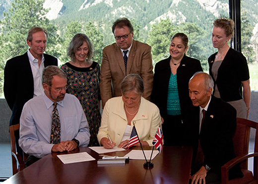
Recognizing the need for greater cooperation in understanding and predicting weather and climate, the U.K. Met Office and NCAR recently signed an agreement to conduct joint research. While many scientists from the two organizations already work together individually, the new arrangement encourages the merging of observing and field programs and facilitates the sharing of insights related to modeling, software engineering, and instrument creation. Specific research that the agreement promotes includes fundamental atmospheric processes, particularly related to the planetary boundary layer; upper-ocean processes and short-term upper ocean-atmosphere interactions in weather and climate prediction; next-generation modeling for massively parallel computing architectures; predictability of the climate system on seasonal-to-decadal timescales; and real-time attribution of hazardous weather and climate extremes to human influences.

Representatives of NCAR and the U.K. Met Office sign the partnership agreement at NCAR's Mesa Laboratory. From left to right, standing: NCAR's William Skamarock, Maura Hagan, and Peter Backlund, May Akrawi of the Office of the British Consulate-General, and NCAR's Rachel Hauser; seated: UCAR's Richard Anthes, Julia Slingo of the U.K. Met Office, and NCAR's Roger Wakimoto.

NCAR Appoints Roger Wakimoto Director

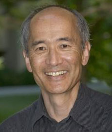
Roger M. Wakimoto, an associate director and senior scientist at the National Center for Atmospheric Research (NCAR) in Boulder, Colorado, and an elected Fellow of the AMS, has been named NCAR’s new director. He succeeds Eric J. Barron, who left NCAR this month to assume the presidency of Florida State University. Wakimoto will assume his new position on February 1.

Roger Wakimoto. (©UCAR, photo by Carlye Calvin.)

“Roger is a world-class scientist and administrator with broad knowledge of both the atmospheric sciences and the university community that NCAR serves,” says Richard Anthes, president of the University Corporation for Atmospheric Research (UCAR), which manages NCAR for the National Science Foundation (NSF), and a past president of the AMS. “I am are very pleased to have him at the helm of NCAR.”
A geophysicist with expertise in tornadoes, thunderstorms, and other types of severe weather, Wakimoto has served since 2005 as director of NCAR’s Earth Observing Laboratory (EOL), which oversees instrument development and major field projects. He has most recently guided the development of a major workforce management plan for NCAR. Wakimoto came to NCAR after 22 years at the University of California, Los Angeles, where he was a professor of atmospheric sciences for more than a decade and also chaired the department.
“I am both excited and honored to take on the challenge of building on the organization’s expertise and leading it in new and potentially exciting directions,” Wakimoto says. “NCAR is in a strong position to help meet the nation’s growing demand for research into weather and climate change.”
At NCAR, Wakimoto oversaw a comprehensive survey of instrumentation to better serve atmospheric scientists, and he collaborated with researchers at other agencies in VORTEX2, the largest tornado field study ever conducted. His ties to the center date back to the late 1970s, when he participated in a field project as a graduate student to study wind shear, a potential threat to aircraft. He has also served on the UCAR Board of Trustees and was chair of the University Relations Committee.
Wakimoto has written or co-authored more than 100 peer-reviewed papers in meteorology and has taken part in a dozen major field projects in the United States and overseas. He has served on numerous committees, panels, and boards for the NSF, The National Academies, the AMS, and other organizations. He has won numerous awards and honors, including a scientific and technical achievement award from the Environmental Protection Agency for observations of air pollution, and the Meisinger Award from the AMS in recognition of his contributions to understanding mesoscale weather events.

AMS on NPR

NPR reporter Jon Hamilton was in Atlanta for the AMS Annual Meeting, searching for the effects of the hacked climate scientists’ emails. He interviewed a number of people at the meeting, with the resulting segment (transcript and audio here) that aired on Morning Edition on Thursday.
The quoted scientists were: Kevin Goebbert, Valparaiso University; Dave Gutzler, University of New Mexico; Chris Folland, UK Met Office; Marcus Williams, Florida State University; and Bill Hooke, AMS Policy Program.

December East Coast Snowstorm a Cat. 3

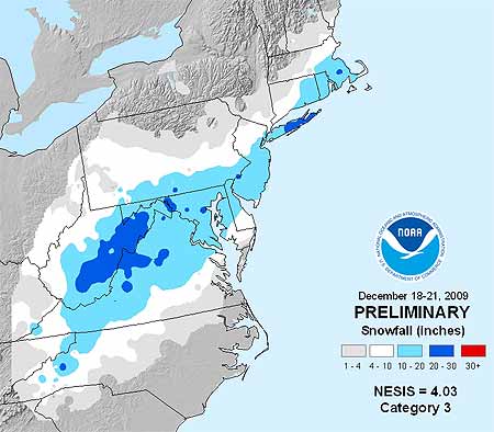
Memories of the pre-Christmas snowstorm that paralyzed travel across megalopolis in mid December might not be as fresh as the severe cold snap that kicked off the new year east of the Rockies. But the storm, which dumped 1-2 feet of snow on the Mid-Atlantic, earned a Category 3 ranking on the Northeast Snowstorm Impact Scale, known as NESIS, classifying it as a “major” winter storm.

December 2009 winter storm snowfall accumulation map
Snow accumulation from the Dec. 18-21, 2009 winter storm. (Credit: NOAA)

NOAA’s NESIS ranks Northeast snowstorms on a five-tier scale ranging from Category 1 “Notable” to Category 5 “Extreme.” It characterizes the storms based on how much snow falls (must deposit at least 10 inches); the size of the area affected,  and the population of the impacted area. Developed in 2004 by renowned winter weather experts Louis Uccelini and Paul Kocin, both with the National Centers for Environmental Prediction, catalogs snowstorms dating back to 1888.
“Last month’s storm was one of only five in the past decade that ranked Category 3 or higher,” says Kocin. The others: December, 2002 (Category 3); February, 2003 (Category 4); January, 2005 (Category 4); February, 2006 (Category 3), and February, 2007 (Category 3). Topping the NESIS scale—and the only winter storms rated Category 5—are the “Superstorm” on March, 1993 and the “Blizzard of ’96” in January, 1996. Last month’s snowstorm fell short of the higher NESIS rankings for several reasons, explains Uccelini.
“While snowfall from the December storm ranked in the top ten for Washington, Baltimore and Philadelphia, the storm only provided a glancing blow to the New York City and Boston metropolitan areas and overall affected a relatively small area. This led to it being classified as a Category 3,” he says.
Although NESIS is the only snowfall index being used operationally by NOAA, there are NESIS-like indices being developed for other parts of the nation. At the AMS Annual Meeting in Atlanta, a presentation by Michael F. Squires (Wednesday, 20 January, 2:00 PM, B211) will discuss the Development of regional snowfall indices.
Addtionally, David Robinson of Rutgers University will introduce a new climate data record of satellite-derived snow cover extent in his presentation Northern Hemisphere snow cover extent during the satellite era (Wednesday, 20 January, 10:30 AM, B218).

Dress for the Ocean's Success


A group of organizations supporting the creation of a national policy to protect oceans, coasts, and lakes  has declared Wednesday, January 13, “Wear Blue for Oceans” Day.  Rallies will be held in 10 cities across the nation, including San Francisco, New Orleans, Honolulu, and Washington D.C. To show your support, organizers are asking you to wear blue, even if you’re not attending, so here are two of our suggestions for tomorrow’s attire.

Harsh Cold Wave Slowly Retreating

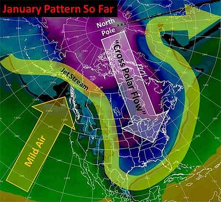
Well, the big winter cold snap that has been gripping much of the United States since December is nearing its end. Temperatures in most places from the Plains to the East Coast have started to rebound and no renewed surges of Arctic air are on the horizon after a final weak front moves through the East Tuesday. But the damage is done in places from the Dakotas and Montana to Florida: burst pipes, roads that drifted shut, and wind chills lower than -50 in the North, and car crashes on icy roads, power outages, and record cold that has chilled the South.

The jet stream pattern for the last two weeks comprises a deep trough over eastern North America that allowed Arctic air to pour into the United States east of the Rockies. (Credit: Chicago NWS Forecast Office)

Last Thursday, the wind chill in Bowbells, North Dakota hit 52° F below zero. That degree of cold “freezes your nostrils, your eyes water, and your chest burns from breathing — and that’s just going from the house to your vehicle,” said Jane Tetrault of Burke County. Her vehicle started, but the tires were frozen. “It was bump, bump, bump all the way to work with the flat spots on my tires,” she said, adding, “It was a pretty rough ride.”
Snow and icy winds whipped southward from the Midwest into Tennessee, Georgia, and Alabama late in the week, making travel a disaster in Memphis and Atlanta. Video of cars sliding off roads or into each other played every half hour on The Weather Channel into the weekend.
Even the Sunshine State had wintry precipitation with this unusual cold surge—something not seen in more than 30 years. The weekend into Monday was especially brutal by Florida standards. With temperatures in the 30s and low 40s, light rain enveloped the peninsula Friday night through Saturday. Sleet fell in spots from Jacksonville and Ocala southward through Orlando, Tampa, and Melbourne into Palm Beach. A few wet snowflakes mixed in here and there with snow reported by trained spotters as far south as Kendall, a southern suburb of Miami. In some places north of Tampa, enough sleet accumulated on cars and outdoor furniture to build little “sleet” men, complete with tiny hats and tree-twig arms, their photos rivaling those taken of snowmen built in Tampa on January 17, 1977. (View a photo of Florida sleet from a snow and ice slideshow on Tampa’s baynews9.com.)
Clearing led to record morning lows both Sunday and Monday that threatened harm to Florida’s $3 billion citrus industry. Temperatures bottomed out at 25° in Tampa, 29° in Orlando, and 31° in Ft. Myers. On Sunday, the temperature in Miami tied the 1970 record for the date with 35°, and a 36° low Monday morning broke the previous record for the date of 37° set in 1927. Despite the records, it has been the duration of the cold, especially in the South, that makes this cold snap memorable. Morning after morning since the previous weekend, photos of Florida strawberries encased in ice showed up on newscasts. Such protective measures against the frigid temperatures are expected for several more mornings in central Florida, even as the chill slowly moderates.
The cold was even long-lasting in the Midwest and Plains, as noted in TWC meteorologist Tim Ballisty’s article “It’s Cold But So What?” last week. He points out that Chicago hasn’t been above freezing since Christmas Day, at the time 11 straight days and counting. Cleveland had 10 consecutive days of snow, and that count continued right into the weekend.
Unlike the extensive heat waves of recent summers, this long and harsh cold snap resulted in relatively few new temperature records. At the Annual Meeting in Atlanta, Gerry Meehl of NCAR will explore the rising ratio of record high temperatures to record low temperatures, which is expected to markedly increase by the middle of the century with current projections of climate warming.

Shedding New Light on Night-Shining Clouds

Photo credit: Pekka Parviainen

Scientists have been making new progress in solving the mysteries of noctilucent clouds [also known as Polar Mesospheric Clouds (PMCs)], thanks to NASA’s Aeronomy of Ice in the Mesosphere (AIM) satellite. AIM recently recorded a series of complete polar seasons of these clouds, which form in the mesosphere and are only visible on Earth when illuminated by sunlight from below the horizon. The satellite’s findings “have altered our previous understanding of why PMCs form and vary,” according AIM principal investigator James Russell III of Hampton University in Virginia.

AIM observed the PMCs in each hemisphere’s summer season at all longitudes and over a latitude range of 60°–85°; this video shows the clouds in the northern skies from late May to mid-August of 2009.

AIM’s data revealed that the clouds form and dissipate at very high speeds and may be affected by high-altitude weather systems.
“The cloud season abruptly turns on and off going from no clouds to near complete coverage in a matter of days, with the reverse pattern occurring at the season end,” Russell said.  Russell likens this seasonal on-off switch to a  “geophysical light bulb” in the presentation he will make about the new findings at the Space Weather Symposium during the AMS Annual Meeting in Atlanta (Tuesday, 8:30 AM, B303).
Noctilucent clouds are made of ice crystals that form when water vapor condenses onto dust particles at extremely cold temperatures (around -210° to -235°F). Scientists are using the new imagery as well as computer models to figure out more about what conditions trigger the clouds. So far, the new data indicate that high altitude temperature determines the onset, variability, and end of the cloud season. Satellite imagery also seems to show relationships to planetary waves as well as smaller scale gravity waves in the atmosphere.