Observations and models–that’s often an uneasy relationship. It’s not always easy to find the common ground needed to turn observations into model input and then models themselves into physically realistic output consistent with those observations.
DOE’s Atmospheric Radiation Measurement (ARM) program is trying to pull observing and modeling—ranging over vast time and space scales—tighter together, into effective bundles of science. Naturally, they’re using an initiative called “LASSO.”
Focused on shallow convection (often small, low-level scattered clouds), LASSO, or, the “Large-Eddy Simulation (LES) ARM Symbiotic Simulation and Observation” project centers on the capabilities of DOE’s Southern Plains observatory in Oklahoma. LASSO is designed to “add value to observations” through a carefully crafted modeling framework that evaluates how well the model “captures reality,” write William I. Gustafson and his colleagues in a paper recently published in the Bulletin of the American Meteorological Society (BAMS).
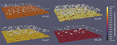
LASSO bundles data such as observations, LES input and output, and “quick-look” plots of the observations into a library of cases for study by modelers, theoreticians, and observationalists. LASSO includes diagnostics and skill scores of the extensive observations in the bundles and makes them freely available with simplified access for speedy use.
The goal of the data packaging approach is to enable scientists to more easily bridge the gap from smaller scale measurements and processes to the larger scale at which most modeling parameterizations operate.
We asked Gustafson to explain:
BAMS: What would you like readers to learn from this article?
Gustafson: In the atmospheric sciences we work with so many scales that we often get siloed into thinking in very scale-specific ways based on our sub-specialty and the type of research we do. This can happen whether we are modelers trying to wrap our brains around comparing parcel model simulations with global climate models, or as observationalists trying to rationalize differences between point-based surface measurements and big, pixel-based satellite measurements. The LASSO project is one attempt to get past limitations sometimes imposed by certain scales. For example, the DOE ARM program has such a wealth of measurements, and at the same time, DOE is developing a new and improved climate model. LASSO is one way to help marry the two together to add value for researchers working with both sets of data.
How did you become interested in the topic of this article?
My training is as a modeler, and over the years, a lot of my research has looked at issues of scale and how atmospheric models can better deal with unresolved detail—the so-called subgrid information. We know that subgrid information can be critical for properly simulating things like clouds and radiation. Yet, we cannot run global models with sufficient resolution to track this information. So, we need tools like large-eddy simulation to help us make better physics parameterizations for the coarser models used for weather prediction and climate change projections. Marrying the LES more tightly with observations seemed like a great way to help the atmospheric community move forward and make progress improving the models.
What got you initially interested in meteorology or the related field you are in?
I find weather fascinating and awe inspiring, and science has always been one of my interests alongside computers. Coming out of my undergrad years with a physics degree, I knew I wanted to pursue something related to computing, but I did not want to do it for a company for the sole purpose of making money for somebody. Atmospheric modeling seemed like a great way to apply my computer interests in an impactful way that would also be a lot of fun. Not many people get to play on giant supercomputers for a living trying to figure out what makes clouds do what they do. I have never looked back and much of my job I see as a grown-up playground where I get to build with computer bits instead of the sand I used to play with as a kid.
What surprises/surprised you the most about the work you document in this article?
This is not an article with filled with “ahah” moments. It is the result of years of effort put into developing a new data product that combines input from a large number of people with many different specialties. So, I would not say that I came across surprises.
However, I have come to really appreciate the help from so many people to make LASSO happen. We have people helping to collect input from dozens of instruments that have had to be maintained, data that has to be quality controlled, computers that are maintained, the actual modeling and packaging of the observations with the model output, the database and website development to make the product findable by users, the backhouse archive support, and communications specialists that have all been
critical to make LASSO happen.
What was the biggest challenge you encountered while doing this work?
Working with a long-term dataset has been one of our big challenges. We have been trying to put together a standardized data bundle that would make it easy for researchers to compare simulations from different cases spanning years. However, instrumentation changes from year to year, which means we continually have to adapt. Sometimes this presents itself as a new opportunity because of a new capability, such as a new photogrammetric cloud fraction product we are starting to work with. Other
times, existing instruments malfunction or are replaced with instruments that do not have the same capabilities, such as a switch from a two-channel to a three-channel microwave radiometer. The latter, in theory, could offer improved results, but in reality, led to years of calibration issues.
What’s next? How will you follow up?
The LASSO activity has been well received and we are excited to be expanding to new weather regimes. During 2020 we have been developing a new LASSO scenario that focuses on deep convection in Argentina. This is really exciting because storms in this area are some of the tallest in the world. It will also be a lot of fun working with LES of deep convection with all its associated cloud motions and detail. We plan to have this new scenario ready for release in 2021.