Hurricane Florence is forecast to slow to a crawl as it nears landfall in the next 24 hours. As a result, some unusual and unimaginable things could happen. People in the Carolinas need to take this hurricane seriously. Even veterans of past landfalls there may be in for a surprise.
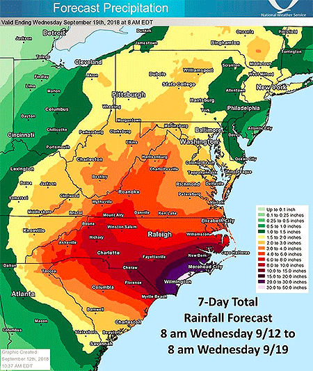
For starters, slow-moving hurricanes often deliver flood disasters. Think last year’s Hurricane Harvey with its 50- to 60-inch rains. The National Weather Service is predicting widespread rainfall in parts of the Carolinas of 10-20 inches. And some areas could be inundated with 30-50 inches as rainbands spiral ashore and hit spots repeatedly, as they did for days in Texas during Harvey.
Then there’s the storm surge. It may be unprecedented. Sure the Carolinas have endured the likes of Hurricanes Hugo in 1989, Fran in 1996, and Hazel in 1954. All brought storm surges topping 15 feet. But all were also moving quickly. A slowing hurricane like Florence could pile up a lot of water.
If it stalls offshore, says storm surge expert Dr. Hal Needham in a Wednesday blog post, “this will serve to dramatically increase the storm surge magnitude and geographic extent of coastal flooding.”
Already the National Hurricane Center expects some portions of the North Carolina coast to realize surge levels of 9-13 feet. A stalling storm piling even more water onto even more of the coast?
Needham points out an “unthinkable,” seeing that forecast models show “Florence making landfall on Thursday evening…and Florence still making landfall on Friday evening. A slow-moving hurricane tracking near a coastline is bad news indeed, as it enables the storm to inflict destructive storm surge along an extended area.”
What’s worse is that the collapsing steering currents may not just delay landfall but also could lead to the hurricane drifting southwest with its core paralleling the South Carolina coast. Initial offshore winds that are increasing as the center moves closer to any point on the coast would drive water ashore in ways unseen in other landfalling hurricanes. Intracoastal waterways could flood barrier islands on their landward sides, and previous precautions for flooding may not be sufficient.
A recent example is 2017’s Hurricane Irma flooding coastal Jacksonville, Florida. When landfalling storms approach Jacksonville from the Atlantic Ocean, winds initially blow from north-to-south. But Irma’s huge wind field instead whipped up a coastal surge from the south, swamping places unaccustomed to surge.
But Florence’s surges may be more than a directional oddity. The hurricane’s offshore winds will initially push tremendous amounts of water away from the coast, much like offshore winds emptied Tampa Bay, Florida as Irma approached. As Florence’s center then passes, Needham explains, “powerful winds in the hurricane’s eyewall, the most intense part of the storm, would immediately shift from offshore to onshore, producing a destructive storm surge in the matter of minutes.” Such sudden, extreme changes are likely to catch residents off guard.
It happened recently in The Philippines. Supertyphoon Hainan’s surge came ashore like a tsunami, Needham says, as the wind shifted direction. He notes that 2013’s Hainan was one of the most intense tropical cyclones to make landfall in recorded history, and he doesn’t expect the surge from Hurricane Florence to move as rapidly.
Still, such a sudden reversal of high winds from a hurricane moving unusually from north to south off the South Carolina coast would push storm surge quickly ashore, devastating the shoreline.
Expect the unexpected with Hurricane Florence. If local authorities tell you to leave, get out.