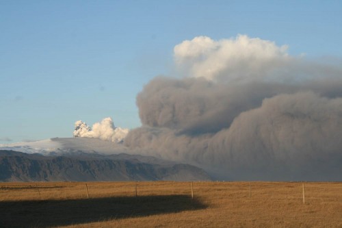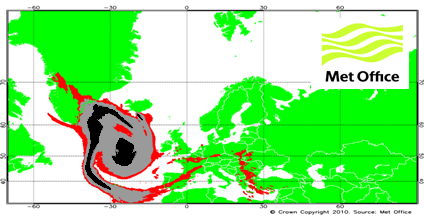
The Eyjafjallajökull volcano eruption in Iceland lasted from the 15 April to 25 May 2010. In addition to threatening local people and their livestock, the volcano sent an ash plume to heights of up to 26,000 feet. Due to the weather conditions, the plume spread over a large part of Europe. Because volcanic ash can cause airplane engines to fail, the plume disrupted aviation over several weeks.
Weather Services played a key role in predicting the spread of the ash and advising the aviation industry. The forecasts were based on safety thresholds for flying through volcanic ash set by the International Civil Aviation Organisation (ICAO) along with the national aviation authorities and aircraft manufacturers.
Scientists modelled the evolution of the ash cloud using dispersion models and trajectory models. The model predictions were compared with observations from satellites, aircraft and ground-based networks.

The eruption of Eyjafjallajökull presented challenges to the meteorological community, especially in Europe. The event highlighted the importance of enhanced international coordination to ensure a consistency of approach in the observation, forecasting and dissemination of volcanic ash information and warnings.
At the AMS annual meeting, papers covering the observing, forecasting and warning to the public and especially to the airline industry regarding the effects of the eruption of Eyjafjallajökull will be presented today (Monday) at the Special International Applications Session 1B: The Eyjafjallajökull Volcanic Eruption of 2010 (1:30 pm). At 2 pm Ian Lisk of the UK Met Office talks about how the aviation industry, grounded by safety rules, put pressure on meteorologists to produce ash concentration charts to supplement the normal information from the Volcanic Ash Advisory Centre in the UK. This was an added burden on dispersion modeling services (with the NAME model), but the results proved promising:
The largest uncertainty in the computer modelling of ash dispersion and transport is the ability to accurately reflect the status of the eruption at model initialization. This is less of a modelling issue and much more a case of being able to accurately and safely observe what the volcano is doing in real time, in particular, the:
•Height, diameter and time variance of eruptive column;
•Assessment of ash concentration and particle size/distribution;
•Ash deposition close to the volcano i.e. ash that is not available to be transported.
Unlike atmospheric phenomena, volcanic eruptions are in fixed places and don’t condense or disappear out of thin air, like atmospheric phenomena…but apparently observing them isn’t much easier.
please have a look at the related presentation :
Eyjafjallajökull volcano ash plume operational monitoring all over Europe with ground based and airborne mounted lidars, by S.Lolli, on Tuesday, 25 January 2011: 4:45 PM
307-308 (Washington State Convention Center)