After the Disasters, How to Be a Holiday-Ready Nation

Weather took hundreds of lives in a record 12 billion-dollar disasters in the United States in 2011. Internationally, the disaster toll is even more startling. Tragedies have been a commonplace. The record-breaking year is a wake up call to the weather and climate community and to the nation as a whole.
Yet, on a holiday eve, a veteran of some of the worst weather of the year shows us how to give thanks. It was at a meeting, “Weather Ready Nation: A Vital Conversation” this month in Norman, Oklahoma, in an emotional presentation by Keith Stammer. If anyone knows what it means to be Weather-Ready, now, it’s Stammer, the emergency manager of Jasper County, Missouri, where basically a third of the city of Joplin was ripped apart by an EF-5 tornado nearly a mile wide.  (You can listen to Stammer’s description of the ordeal on-line.) Yet here’s how he started his talk:

The big thing you need to understand about Joplin is that at nighttime it is a city of 50,000 people; in the daytime it’s a city of a quarter of a million.  A lot of people come in for shopping, medical, for work. The one thing that translates, into in terms of this particular disaster, was that we are most grateful that it happened on Sunday evening, and not Monday evening, or the totals would have been absolutely different.

That’s a remarkable perspective to take after 162 people died, over a thousand were injured, and nearly 17,000 dwellings were lost. It’s a way to live after a year like 2011.
The discussion about making this country more resilient to the battering and bruising of a violent atmosphere, begun in Norman, will continue at our meeting in New Orleans next month. A Monday lunchtime Town Hall by the same name, organized by the leaders of the Norman conference, will be a highlight (12:15 p.m., Room 238). After Christmas, we’ll report on some of the Weather Ready Nation ideas and comments in The Front Page as preparation for the week’s deliberations.
But before refueling our minds for the Annual Meeting, a holiday is a time to replenish the heart and to experience community, so listen again to Stammer, who ended his talk thanking the 114,677 different people who stepped forward, registered as volunteers, and put in some 697,817 hours of service so far to help Joplin recover (more than a million cubic yards of debris removed so far):

All disasters are local, they start locally; they end locally, they may in fact rise to national prominence somewhere in between as ours did, but in the end, with all due respect, all of you foreigners are going to go away and we’re still left to have to handle it.  I think one of the things that helped us here is the fact that everybody was willing and able to look at this as a local effort. I can tell you that we did not have one organization or person that stood up and said, I’m in charge, you’re not, get over it. It was in fact a collaborative effort from the get-go and remains to be so today.

We are honored to celebrate a holiday with folks like that. We will be proud to make a Weather Ready Nation with them, too.
Emergency Response Technology Goes On Demand

When the American Red Cross responded the morning after the 24 May tornado outbreak in central Oklahoma, they had a new tool in their pocket. The Warning Decision Support System—Integrated Information (WDSS-II), developed by NOAA’s National Severe Storm Lab, cut disaster assessment time from 72 hours down to 24, a major improvement that could save many lives when it comes to rescue in the wake of a disaster.
The WDSS-II works by narrowing when and where the severe weather most likely occurred. Using radars, satellites, and other observation systems, the On Demand feature of the tool records tracks of rotation and hail swath images that can be opened in Google Earth. When street maps are overlaid with these images, disaster teams can assess which areas likely need assistance first, as well as the most accessible routes to take.
“They no longer have to put boots on the ground to visually assess the situation before planning how they will deploy response teams,” comments Kurt Hondl, NSSL research meteorologist. “It makes the coordination and planning of the American Red Cross’s response so much more efficient.”
The WDSS-II On Demand software is available to American Red Cross officers and other assessment organizations. More than 250 volunteers in Oklahoma and Texas have been trained so far by the Red Cross to utilize the NSSL On Demand software.  Other organizations, like FEMA and the Department of Homeland Security, have begun to take advantage of the technology as well.

Oklahoma Mesonet Station Stands Tall in EF-4 Tornado

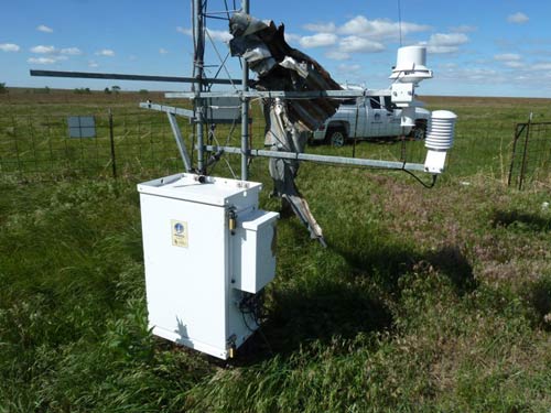
The morning after the tornado: still standing tall.

by Chris Fiebrich, Oklahoma Climatological Survey
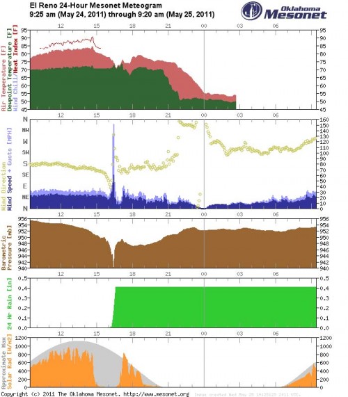
It was bound to happen eventually.  The Oklahoma Mesonet has 120 weather stations across the state, about one every 30 km.  Since 1994, we’ve had a lot of close calls with severe weather, but the highest wind speed ever recorded had been 113 m.p.h. at our Lahoma station during a thunderstorm in August 1994.  That all changed on May 24, 2011 when a strong tornado clipped our El Reno station.   The graph below shows that winds gusted to 151 m.p.h. shortly after 4:20 PM.  Along with the wind gust, the station recorded a strong pressure drop.

At this time, the tornado has been rated as “at least EF4”  (see http://www.srh.noaa.gov/oun/?n=events-20110524-pns1 for the latest on the tornado ratings).  The tornado was on the ground for 75 miles.  It’s center was likely several hundred yards north of our station as it blew through.
A piece of flying debris sheared off the station’s 2 m anemometer just after it reported a wind gust of 126 mph.  The station’s temperature aspirator was also damaged, and one of the tower’s guy wires was snapped. A piece of metal debris was found wrapped around the tower. Despite minor damage, the tower stood tall and the official 10 m anemometer survived in perfect condition with a piece of metal debris wrapped around it.  A large nearby tree was found uprooted and thrown across the roadway.
More pictures can be found on the Mesonet Facebook page at http://www.facebook.com/mesonet.

Deadliest Tornado in Modern Era Slashes Missouri

It hasn’t even been a month since violent, history making tornadoes made headlines across the United States, and yet here we are with another grim tornado record. The death toll from the violent tornado that shredded as much as a third of Joplin, Missouri, Sunday evening reached 116 Monday afternoon. That makes it the single deadliest tornado to strike the United States since NOAA began keeping reliable records of tornado fatalities in 1950. It took the top spot from the Flint, Michigan, twister of June 8, 1953, which killed 115.
The number of dead in Joplin jumped from 89 earlier in the day as news of recoveries as well as rescues were reported. While the number of dead is fully anticipated to increase, news outlets reported that at least five missing families were found buried alive in the rubble, which stretches block after unrecognizable block across six miles of the southwestern Missouri city of 50,000. More than 500 people in Joplin were injured, and the damage is eerily familiar, looking so much like the utter carnage witnessed in Tuscaloosa  on April 27, 2011, when 65 died in that day’s twister.
The tornado event attributed to the single highest loss of life on American soil is the “Tri-State” tornado of March 18, 1925, which rampaged across southeastern Missouri, southern Illinois, and into southwestern Indiana. It killed 695 people on its seemingly unending 219-mile journey. But that was prior to our knowledge of families of tornadoes and the cyclical nature of long-lived supercell thunderstorms to form, mature, dissipate, and reform tornadoes, keeping damage paths seemingly continuous.
Prior to the effort by the U.S. Weather Bureau, precursor to the National Weather Service and NOAA, to maintain detailed accounts of tornadoes—and 64 years before yesterday’s event in Joplin—the last single-deadliest tornado in a long list of killer U.S. tornadoes was the 1947 Woodward, Oklahoma, tornado, which claimed 181 lives.
Yesterday there was also one fatality from a destructive tornado that hit Minneapolis, and that and Joplin’s toll combined with last month’s back-to-back tornado outbreaks, plus a handful of earlier tornado deaths this year, brings 2011’s death toll from tornadoes to 482—more than eight times the average of the past 50 years and second (in the modern era) only to the 519 recorded deaths from twisters in 1953. Two-thirds of this year’s fatalities occurred during April 27’s epic tornado outbreak across the South.
The Weather Channel has been providing continuing coverage of the rescue and recovery efforts in Joplin, with one of its crews arriving on scene moments after the tornado. The level of destruction in the city was too much to bear even for one of its seasoned on-air meteorologists. TWC also is reporting along with NOAA’s Storm Prediction Center on the possibility of yet another tornado outbreak, this time in the central Plains on Tuesday.

Policy Buzz: Senate Hearing Follows Tornado Outbreak

by Caitlin Buzzas, AMS Policy Program
On May 3, Dr. William Hooke, Director of the AMS Policy Program, testified before Senator John Rockefeller (D-WV) and other members of the U.S. Senate Committee on Commerce, Science and Transportation. He was joined by Bob Ryan, Senior Meteorologist at ABC7/WJLA-TV, Dr. Anne Kiremidjian of Stanford University and Dr. Clint Dawson of the University of Texas, together they discussed “America’s Natural Disaster Preparedness: Are Federal Investments Paying Off?”
As the hearing was convened in part as a response to the earthquake in Japan, Dr. Kiremidjian focused her testimony on earthquake and tsunami issues. Dr. Dawson discussed advances in storm surge modeling.
This hearing (full video here) took place soon after one of the worst weather disasters in the U.S. of the last century with tornadoes killing at least 327 in the South East. According to the National Oceanic and Atmospheric Administration (NOAA) this may have been the largest tornado outbreak in U.S. history. Although this disaster was horrific in terms of the many lives lost and the huge economic toll, the hearing gave our community the needed opportunity to highlight what we do and the importance of accurate weather forecasts and earth observation systems.
Dr. Hooke stated in his testimony that these systems and science play an especially important role in the United States:

Because of its size and location, the United States bears a unique degree of risk from natural hazards. We suffer as many winter storms as Russia or China, and as many hurricanes as China or Japan. Our coasts are exposed not just to storms but to earthquakes and tsunamis. Dust bowls and wildfire have shaped our history. And 70% of the world’s tornadoes, and some 90% of the truly damaging ones, occur on our soil.

Ryan emphasized in his testimony that amidst the many scientific improvements, the whole weather forecast process is a multisector enterprise that depends on the capabilities of, and cooperation with, Federal agencies.  The Joint Polar Satellite System (JPSS) is an example of that critical Federal capability. As Congress decides what to cut in the upcoming budget deliberations, programs such as the JPSS will have to get the recognition they deserve to keep functioning. The data and imagery obtained from JPSS will increase the timeliness and accuracy of public warnings and forecasts of climate and weather events, thus reducing the potential loss of life and property. This has a direct effect on the health and stability of our national economy. It is important, even in a time of economic hardship, to keep programs like JPSS fully functional for the long-term health of the country. Both Hooke and Ryan made this point. Said Ryan:

Some may argue that loss of polar orbiting data will not degrade our current weather/climate observing and forecasting skill . . . but, what if they are wrong! Polar and geostationary weather satellites are an integral and critical core element of providing very accurate weather forecasts and life saving planning and decision making for weather and other natural disasters from tornadoes and hurricanes to fires, drought, dangerous air quality and oil spills.

As Dr. Hooke highlighted in his testimony there are several other things that can be done to improve our current disaster preparedness:

  • Maintain our essential warnings system
  • Bring to bear not just meteorology and engineering, but also social science
  • Learn from experience
  • Build public-private partnerships
  • Explore No-Adverse Impact Policies for flood and other hazards
  • Track progress/keep score. (There’s more about this proposal on Dr. Hooke’s blog, Living on the Real World.)

The issues that our community deals with everyday, highlighted through a hearing of this kind, are not just important to the world of science and meteorology, but important to the health and stability of the American economy and public as a whole. I believe that Senator Rockefeller, Senator Nelson, Senator Boxer and others left the hearing with not only a greater understanding of our community and the important role that we play in the health of our country, but with a continued desire to highlight the importance of our work.

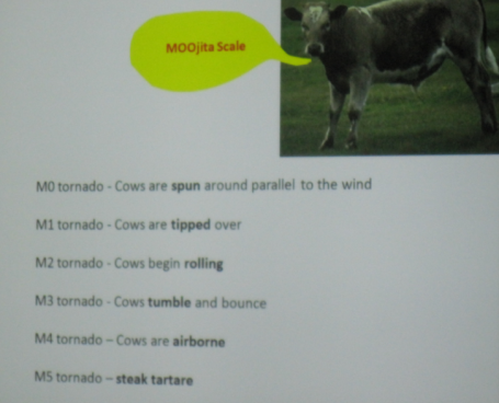
Moove Over, Dr. Fujita!

Thanks to Paul Douglas and D.J. Kayser for a report on Josh Wurman’s presentation at St. Cloud State University about the Doppler on Wheels project (based at the Center for Severe Storm Research in Boulder, Colorado).

Dr. Wurman explained that since the DOW project started about 15 years ago, the vehicles have seen between 160-170 tornadoes, about 15-20 of them with the VORTEX 2 project which was aimed at better understanding tornado formation and to hopefully push the lead time out for tornadic storms. Part of Dr. Wurman’s research is also to study the lower level winds of a tornado in hopes to come up with an even better Fujita Scale (yes, different from the current Enhanced Fujita Scale) and hopefully be able to better warn areas that would be impacted by tornadoes, especially since there is currently little ability to forecast the intensity, duration, and size of tornadoes, unlike we can with hurricanes.

Even with that kind of experience it doesn’t look like Wurman’s udder tornado scale will be putting Fujita’s version to pasture any time soon.

No Do-Overs for Plainfield, Please

If ever there was a day meteorologists might like to do over, it was exactly 20 years ago today, on 28 August 1990. Somehow, on an afternoon originally projected to have a mere moderate risk of severe weather, an F-5 tornado—the only such powerful tornado in August in U.S. history—struck northern Illinois, killing 29 people in the small town of Plainfield, just 30 miles southwest of Chicago.
The sky turned black, and few people knew what happened as the rain-wrapped tornado ripped through the landscape. Almost no one saw the funnel. (Paul Sirvatka, just then starting up his College of DuPage storm chasing program was a rare exception.) Even though another tornado was spotted earlier in the afternoon in northern Illinois, no sirens wailed in Plainfield until too late. No tornado warnings were issued until too late.
Tom Skilling (WGNE-TV) broadcast a report this week for the 20th anniversary of the tragic tornado, explaining why warnings would likely be much better should similar weather now threaten the Chicago area.

The gist of the story: back in 1990 Chicagoland didn’t have NEXRAD Doppler radar and other recent advances in observing and modeling. Also, the aftermath led to a reorganization of the overworked Weather Service meteorologists in Illinois, narrowing the purview of the Chicago office and adding more offices to help cover the state.
While most stories in the media (for example, also here) have been showing why 20 years have made a repeat of Plainfield’s helplessness less likely, Gino Izzo of the NWS Chicago office decided to have a do-over anyway–on the computer. At his presentation for the AMS Conference on Broadcast Meteorology in June, Izzo described how he reran the severe weather forecasts for 28 August 1990 using the North American Regional Reanalysis and the most up-to-date model of 2010, the Weather Research & Forecast model (WRF) from UCAR.
With a nested 4 km grid at its most detailed, Izzo ran the WRF overnight–it took 10 hours on the available computer in the office–and found that in fact, with the observational limits of 1990, the latest, greatest numerical forecasting doesn’t really improve the severe weather outlooks for the Plainfield disaster. The WRF moved the likely areas of severe weather (not tornadoes necessarily, but probably winds associated with a bow echo) too far eastward. Only when the model time horizon was getting within a few hours of the killer tornado did the severe weather outlook for northern Illinois start to look moderate, as the model begins to slow down the eastward progress of the cold front.
Audio and slides from Izzo’s striking presentation are available on the AMS meeting archive. The message is pretty clear: no matter how good the models get, Doppler radar, wind profilers, aircraft-based soundings, and satellites make a huge difference in our severe weather safety these days.
Of course, with or without better warnings, a repeat of the Plainfield disaster would be potentially catastrophic. The area has more than doubled its population since 1990. And 28 August just happened to be one day before school resumed for the fall—few people were at the high school that was totally destroyed that day. Even just a day’s difference, let alone two decades, could have been critical. Nobody wants a do-over.

Atlanta Tornado and Impacts: Weather 2009

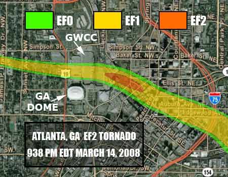
In the evening of March 14, 2008, the Georgia World Congress Center where the 90th Annual Meeting of the AMS is taking place this year was hit by an EF2 tornado. The supercell thunderstorm that produced the tornado was unexpected that day, with an outbreak of tornadoes forecast for, and subsequently realized, the next day.

Portion of 2008 Atlanta tornado track
Track and intensity of Atlanta tornado through downtown. (Adapted from NWS Atlanta tornado report.)

The adjacent Omni Hotel as well as CNN Center and a number of nearby hotels and buildings suffered significant damage in the tornado. CNN Center alone lost more than 1600 windows, and windows are still missing in the tube-shaped Westin Peachtree Plaza tower.
CNN was not broadcasting live from Atlanta that night with programming instead coming from its New York and Washington offices. If the 24-hour network had been live from CNN Center, “It could have been a classic You Tube moment,” says Brandon Miller, a weather producer for CNN International, adding, with “us in the center of the tornado, anchors looking all around, fear on their faces … Fortunately, that didn’t happen.” Miller says CNN didn’t cover the tornado strike itself live, but “covered the heck out of the damage afterwords.”
While this tornado event won’t be presented as part of Impacts: Weather 2009 at the 2010 AMS Annual Meeting, a presentation during this Tuesday session will look at Tornado Effects on a Rural Hospital: Impacts of an EF-3 Tornado that struck Americus, Georgia in March 2007 (2:00 PM, January 19, 2010, B206). A presentation Wednesday morning (9:15 AM, B217) will look at lightning characteristics of the Georgia tornado outbreak the day after the 2008 Atlanta tornado. Its author commented that lightning characteristics of the tornadic storm that struck Atlanta the previous day might also be presented, if time allows.
Also, a poster to be presented Monday will investigate the relationship, if any, between Southeastern tornadoes and drought. A climatological analysis of antecedent drought and spring tornadic activity will be available for viewing during the poster session Observed and Projected Climate Change from 2:30 – 4:00 PM Monday, January 18.