Jack Townsend, Shepherd of Weather Satellite Technology

The passing of AMS Fellow John W. (“Jack”) Townsend on October 29 serves as a fitting moment to register the evolving national relationship with space technology over six decades.

“Jack Townsend was truly one of the seminal figures in the history of NASA, and certainly, in the history of Goddard,” said current Goddard Spaceflight Institute Director Rob Strain. “The story of the space program simply could not be written without a chapter devoted to him. He dedicated his life to the exploration of space and the study of our planet, and humankind is richer for the knowledge he helped generate.”

Townsend was one of the first employees at Goddard in 1959, where he directed the satellite applications efforts, at a time when the nation was racing to enter the Space Age. He had already cut his teeth on space technology, first in radar countermeasures aboard B-29 bombers in World War II and, by 1949, working with V-2 rockets. Townsend helped bring satellite meteorology to fruition in the 1960s as Deputy Administrator of the Environmental Science Services Administrator (predecessor to today’s NOAA). After a decade at Fairchild Industries, he returned to NASA after the Challenger disaster, and then for three years as Director of Goddard.

Townsend retold the story of the origins of weather satellites just a year ago in an interview with archivist/historian Doria Grimes:

[E]verything started with sounding rockets just after World War II. I went to work for the Naval Research Laboratory (NRL) following my graduate degree in physics. The sounding rocket program had just started at NRL and it involved the Army, Navy, and Air Force…. Interestingly enough, at White Sands, New Mexico, we flew rockets out over the desert in the late 1940’s. We put cameras on them called gun sight aiming point cameras, “GSAPs”. The idea of the camera was that as the rocket went up and rotated, it took pictures of the earth in swaths. You would use those pictures to reconstruct the attitude of the rocket.

One day we had a shot in New Mexico in which we caught what looked like a storm in pictures off to the southeast. One of the guys who worked for me, Otto Berg, made a composite picture of nearly 1,000 tiny GSAP pictures, a total mosaic of a storm. It looked exactly like a hurricane, and attracted the Weather Bureau’s attention. It was in the early 50’s – all before Sputnik.

The pictures stirred interest from Harry Wexler at the Weather Bureau, and eventually a classified Army satellite project was moved into the new NASA, gradually became declassified, leading to the first weather satellite, TIROS. It was during this period that Townsend and other American science administrators were involved with negotiating peaceful uses of space technology with their Soviet counterparts.

The subject came up of transferring data. We, at that time, expected to launch the research meteorological satellites. They promised they were going to launch meteorological rockets and satellites. Incidentally, they never did. But they wanted the transferred data because Russian ground data was very sparse, and these data meant a lot to them as a country. With the free transfer of meteorological data and satellite pictures, we had an issue, a big issue. Who pays for the communication expenses between Washington and Moscow? We got into a big fight about that, and the agreement had been to share. The Russians said that since the U.S. owns all these communications facilities, the U.S. should pay for 90% of it. Then the Russians said that the ruble was not worth as much money as the dollar. Finally, I came up with one of the only brilliant ideas I ever came up with. I said sharing means 50/50. We’ll pay the bill for three months, and you pay it for three months….So I cut this deal with the Russians on how to pay for it. [His Russian negotiating counterpart] Blagonravov thought it was funny. He laughed, and said to me, “I am glad I am too old to send to Siberia.” He was a lieutenant general which is a five star rank in those days, and he also was a communist and believed in the system. He was a neat guy and I got to like him.

The whole interview (transcript here) has more on the origins of the space program, NOAA, and operationsl satellites. You’ll get the sense that the field was guided then by strong personalities and a country committed to technology. [For more on the early development of weather satellites, specifically TIROS, check out James Rodger Fleming’s presentation on “Transformative Technologies and International Cooperation in the Career of Harry Wexler” at the 2012 AMS Annual Meeting (11 a.m., Tuesday 24 January)].
Python in New Orleans: Once Bitten, Quickly Smitten

The upcoming 2012 AMS Annual Meeting in New Orleans is only the second with a whole symposium devoted to the use of Python programming language in the atmospheric sciences. The first was last year’s meeting in Seattle.
The quick return of Python to the conference program–including beginning and advanced short courses over the weekend (21-22 January)–suggests what a growing community of modelers and programmers already knows. Once they’ve encountered the Python language, people tend to become devotees.
“Python is an elegant and robust programming language that combines the power and flexibility of traditional compiled languages with the ease-of-use of simpler scripting and interpreted languages,” according to Filipe Pires Fernandes of  the School of Marine Science and Technology in New Bedford, Massachusetts, who presents Monday (23 January, 2 p.m.).
Python, for example, is at the heart of the National Weather Service’s graphical forecast editor (GFE) tool and thus at the basis of the usage of the whole gridded forecast product suite in effect over the last decade. “Python’s introspective capabilities permitted developers to build a tool framework in which forecasters could write simple expressions and apply them directly to the forecast process without the burden of needing to know details about data structures or user interfaces,” writes Thomas LeFebvre of NOAA, who will discuss (Tuesday, 24 January, 8:30 am) how “a large part of GFE’s success is the result of the rich set of features that Python offers.”
Symposium Chair Johnny Lin of North Park University produced a short video to explain the attraction of Python, now the “eighth most popular programming language in the world” and preview the upcoming symposium:

The symposium program features numerous new software packages, with many of the presentations demonstrating how Python is a solution to software quirks and limitations that have become more bothersome as technology advances. One presenter is using Python to display data and model output on Google Earth. Another developed a new Skew-T diagram and Hodograph visualization and research tool (SHARPY), recasting a standard program, SHARP, in Python. Explains Patrick Marsh of NOAA’s National Severe Storms Laboratory: “Unfortunately, SHARP utilizes several GEMPAK routines which makes compiling, let alone installing and using, a non-trivial task.”
Andrew Charles of the Bureau of Meteorology in Australia used Python to create a web-based tool to integrate contour plotting with GIS applications. “With ever increasing amounts of data being made available, the related increase in required storage means static plots are not a viable solution for the delivery of all maps to end users,” writes Charles about his (11:30 a.m. Tuesday) presentation. “Contour plots are one of the most used data visualisation techniques in meteorology and oceanography and yet, surprisingly, there are few available solutions for the generation of contour plots to be used as map overlays from live data sources.”

Emergency Response Technology Goes On Demand

When the American Red Cross responded the morning after the 24 May tornado outbreak in central Oklahoma, they had a new tool in their pocket. The Warning Decision Support System—Integrated Information (WDSS-II), developed by NOAA’s National Severe Storm Lab, cut disaster assessment time from 72 hours down to 24, a major improvement that could save many lives when it comes to rescue in the wake of a disaster.
The WDSS-II works by narrowing when and where the severe weather most likely occurred. Using radars, satellites, and other observation systems, the On Demand feature of the tool records tracks of rotation and hail swath images that can be opened in Google Earth. When street maps are overlaid with these images, disaster teams can assess which areas likely need assistance first, as well as the most accessible routes to take.
“They no longer have to put boots on the ground to visually assess the situation before planning how they will deploy response teams,” comments Kurt Hondl, NSSL research meteorologist. “It makes the coordination and planning of the American Red Cross’s response so much more efficient.”
The WDSS-II On Demand software is available to American Red Cross officers and other assessment organizations. More than 250 volunteers in Oklahoma and Texas have been trained so far by the Red Cross to utilize the NSSL On Demand software.  Other organizations, like FEMA and the Department of Homeland Security, have begun to take advantage of the technology as well.

Kermit Would Approve

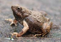
It’s not easy being green, as Kermit the Frog famously lamented on the TV show, “Sesame Street,” but it might be getting easier thanks in part to the Tungara frog—a native of Central and South America. David Wendell of the University of Cincinnati recently led a study that developed a new type of foam that can absorb CO2 and convert it to sugar before it escapes into the atmosphere (a process that occurs naturally in plants during photosynthesis). A key ingredient in the foam, which could be placed into the exhaust systems of power plants, is a protein that is naturally created by the Tungara frog to form a foam nest that protects their eggs. (Here’s a brief video showing a frog weaving the nest.)  
“I read about a protein that the frog uses that allows bubbles to form in the nest, but doesn’t destroy the lipid membranes of the eggs that the females lay in the foam, and realized that it was perfect for our own foam,” says Wendell. The CO2-absorbing foam is an amalgam of numerous enzymes harvested from plants, fungi, bacteria, and frogs, and it converts all of the solar energy it captures into sugars, making it as much as five times more efficient than plants, and, according to Wendell, “the first technology that actually consumes more carbon than it generates.” The invention recently won the $50,000 grand prize at the 2010 Earth Awards, which were founded in 2007 to encourage innovative designs “to improve our quality of life and build a new economy.”