“Weather in Action”: Training Meteorology Students to Chase Storms

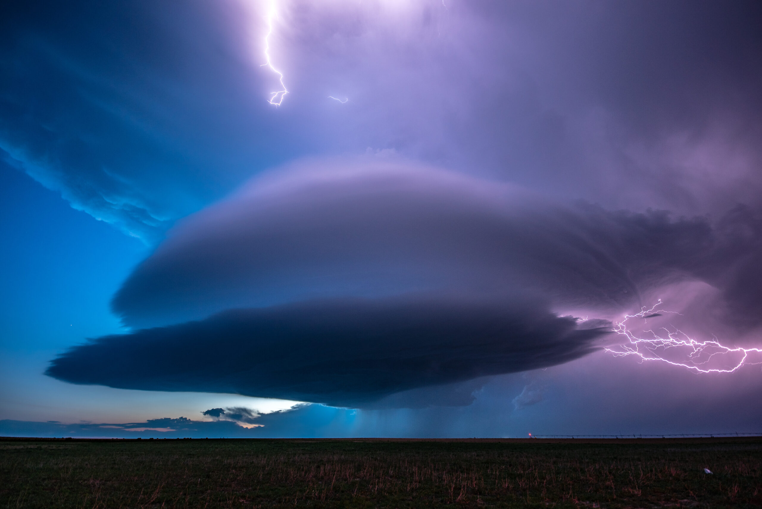
Photo "Walsh Mothership" by Michael Seger shows a rounded storm from a distance at twilight, with a lightning flash in the sky in the foreground. The photo was voted Member's Choice in the 2023 AMS Weather Band Photo Contest.

A Session Spotlight for the 24th Annual AMS Student Conference

This January, the 24th Annual Student Conference will host the first storm chasing training ever held at an AMS meeting! Jennifer Walton of AMS partner organization Girls Who Chase (GWC) and Robin Tanamachi of Purdue University (currently on sabbatical with UCAR COMET/MetEd), will teach Student Conference participants skills and strategies for more safely experiencing “meteorology in action.” We spoke with Jen Walton about what to expect, and what meteorologists and other scientists should know about storm chasing!

What should Student Conference attendees expect from this storm chasing training? Why is this a good venue for such a training?

Given the release of “Twisters” in July 2024, and knowing how many folks were inspired by the release of the original Twister movie in 1996, the conference organizers felt it was fair to expect a significant increase in people storm chasing (and likely also new meteorology students!). Some new chasers are likely to be meteorology undergraduate and graduate students attending the student conference. We want to get ahead of this rush — and encourage future meteorologists to get out into the field and see meteorological processes in person. GWC now has a reputation for offering accessible, entry-level storm chasing education programming via our annual Spring Training event, held in partnership with COMET’s MetEd program, so we were an obvious candidate for the job.

Given the strong interest in storm chasing over the decades and the potential for a spike in new chasers, GWC and AMS can contribute to the development of a more safety- and education-minded population of chasers by creating accessible educational resources and fostering a welcoming, inclusive community. This training is part of that conscious endeavor. 

Learning to storm chase involves the development of several additional, important skill sets that don’t directly translate out of what folks learn from a meteorology degree. As we all know, when it comes to weather, things don’t always work out the way we think they will, and no two storms will behave exactly the same way because of constantly evolving environmental factors.  So even if you have a solid atmospheric science background, it’s helpful to pair an understanding of forecasting with other skills. For example, topics such as translating radar to reality, chase strategy and positioning, safety planning and strategy, and knowing how to prepare for a day in the field are all useful for a budding chaser. Those things definitely take more than a couple of hours to learn about, so this training will be more of a “learn how and where to get started” course, with some clear actionable next steps for those who want to continue their learning journey. And of course, we’ll have some fun stories and videos to share.

Why would atmospheric scientists want to chase storms?

I like to quote Ginger Zee on this one, because she’s a longtime storm chaser who is a big proponent of meteorologists experiencing severe weather firsthand. From her perspective, storm chasing really drives home a deeper understanding of severe weather and the dynamics at play during a severe event. It can also ultimately help meteorologists better communicate with their audience, when relevant, because they have actually experienced some of what they are forecasting firsthand. 

I think there is much to be gained from getting outside for a day or more — seeing weather in action really fills in the gaps when it comes to understanding how various processes take place. For example, storms might look structurally similar on radar, but every storm is completely unique in some way. The only way to fully understand that is through experience. Even if folks have no plans to include field work in their future endeavors, understanding how severe weather can evolve, seeing it with your own eyes, and even perhaps witnessing some of the impacts it can have on people and property can more fully develop a new meteorologist. Some folks have made career decisions, like pairing emergency management or public health with meteorology, based on their personal experiences in the field. You just never know.

How did you get into storm chasing, and what made you want to teach others?

I’ve had a 20-year career in environmental and climate communication, but always assumed chasing wasn’t for me — until one day I decided that was silly because I’ve always been pretty obsessed with severe weather. I finally sent myself on a storm chasing tour in 2018 to check it out. I saw my first tornado on my own shortly after that, 45 minutes from my home in Colorado, and the rest is history. I spent the following several years studying forecasting, learning via making lots of mistakes chasing on my own, and discovering the very real joy of witnessing some truly incredible stuff.

The creation and evolution of GWC is rooted in that journey. Due to my background, I had the wherewithal and tenacity to find the people and resources I needed to learn to chase, but it wasn’t easy, and there was very little training available. My storm chasing tour folks gave me the basics and I continued on my own from there. It seemed like a no brainer to start pushing out resource listings and soon, trainings, via GWC. Our attendance at Spring Training in 2023, our first year, blew me away, and then we nearly doubled that number in 2024. 

I’m excited to continue to expand this type of education into different weather circles, and even more excited to bring it to AMS!

Why is increasing accessibility and diversity in weather and storm chasing so important right now?

There’s clearly interest in learning about chasing and severe weather, and I think a bit of a hunger for learning in safe, welcoming environments. The sciences don’t always seem terribly open to a general enthusiast, yet weather affects literally everyone on the planet. It’s crucial that people understand the basics of how to keep themselves and their loved ones safe, especially as the frequency and intensity of severe weather events continue to increase globally. Now is not the time for people to feel like they aren’t welcome in a learning environment, no matter their gender, ethnicity, background or knowledge level. 

Does GWC offer other resources for people interested in storm chasing safely?

If folks would like to take the next step after the student conference training — or aren’t attending the Student Conference — I certainly encourage them to check out our library of free learning resources we maintain on the Girls Who Chase Education page. And if active training is more someone’s style, definitely check out Spring Training 2025, a one-day, virtual, affordable training event that offers in-depth foundational, operational and accessible information and training material for storm chasers at all levels, and the chance to speak with experts in the field. We record every Spring Training event as well, to create a library of resources people can use to start learning anytime!

Learn more about this training, and about the AMS Student Conference!

Photo at top: Photo “Walsh Mothership,” by Michael Seger, won Member’s Choice in the 2023 AMS Weather Band Photo Contest.
BEST: Capturing the Worst Tornado Winds

Greenfield tornado

Greenfield, Doppler on Wheels, and what happens where a twister meets the ground

By Katie Pflaumer, AMS Staff

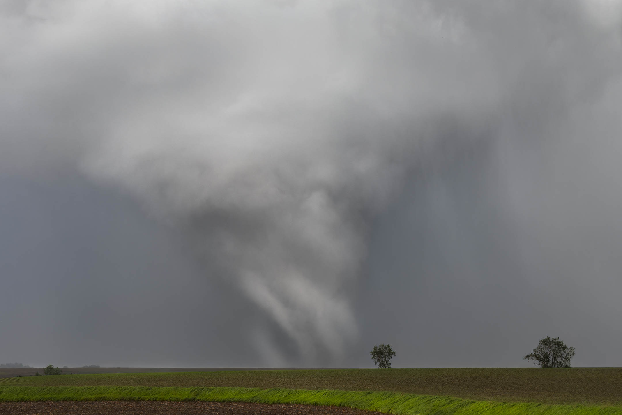
Featured image: The Greenfield tornado, south of the town. Photo credit: Lauren Baca.

On 21 May, 2024, a powerful tornado hit the town of Greenfield, Iowa. A mobile team from the NSF BEST project was able to capture radar and instrument data, measuring one-second gusts among the highest ever recorded. Karen Kosiba, PhD, Principal Investigator (PI) of the BEST project, and Jen Walton, founder of AMS partner organization Girls Who Chase, were both part of the team who intercepted the Greenfield tornado. We spoke with them about what it was like, and what their valuable data might yield.

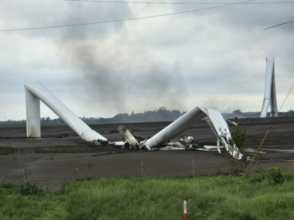
The tornado that hit Greenfield was fast, narrow, and violent, cutting a 44-mile path through southwestern Iowa. Moving into town from the southwest, it had already destroyed wind turbines and family farms, with multiple vortices visibly rotating around its center. 

But as it neared Greenfield, where it would kill five people, the tornado was obscured by a cloak of rain. Racing toward the town with her colleagues, Jen Walton told me, “We could see nothing but a wall of white ahead of us.” They were trying to put themselves right in the path of a hidden monster.

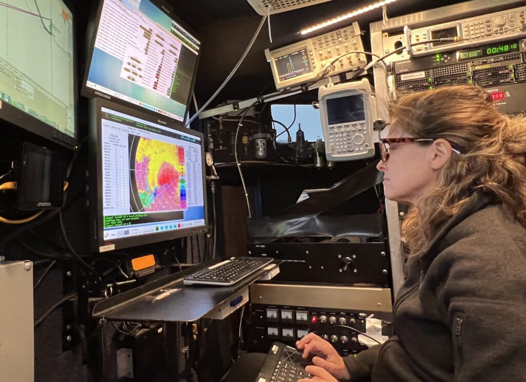
Karen Kosiba wouldn’t have seen it anyway, although she was less than a quarter of a mile from the vortex. “I [almost] never look out the window,” she told me. Her attention was glued to the radar screen. As Principal Investigator on the NSF-funded BEST (Boundary-layer Evolution and Structure of Tornadoes) project, her job was to track the path of the tornado on radar so their team could get close enough to obtain high-resolution dual-Doppler radar and weather instrument data of the tornadic winds closest to the surface of the earth. 

They had sped through Greenfield, and her mobile radar vehicle was now parked just to the east of town, hoping for a clear line of sight in the hilly, tree-covered terrain. “I’m operating the radar, we’re basically scanning through this [storm], tracing the path of the tornado, and it was getting more and more obvious it was going to go through Greenfield,” she said.

Karen Kosiba in DOW
Dr. Karen Kosiba reading the radar screen in a DOW vehicle. Photo credit: Jen Walton/FARM Facility.

DOW(n) Low with Tornadoes

Obtaining high-resolution data from tornadoes is incredibly difficult using stationary instruments and radars — especially for near-surface conditions. The earth’s curvature and obstacles like trees and topography mean that far-away radars simply can’t get a good view of where a twister meets the ground. Also, because of beam spreading, far away radars have worse spatial resolution. Josh Wurman invented the Doppler on Wheels (DOW) network of truck-mounted Doppler radars — now part of the University of Illinois’ Flexible Array of Radars and Mesonets (FARM) Facility — in the 1990s to address challenges like these. DOWs have been used all over the world to look at everything from hurricanes to flooding and wildfires.  

FARM missions currently involve some combination of their four DOWs, a variety of support vehicles equipped with mesonets, and quickly deployable weather stations (Pods), as well as weather balloon-borne instrumentation. The equipment has advanced greatly since the ’90s, Kosiba says. “We scan fast, with really short gates that get us fine-resolution … dual-pol data, which is important for understanding debris signatures and inferring microphysics.” 

The BEST project (which Kosiba co-leads with Wurman) deploys DOWs, Pods, and weather balloons to study boundary-layer tornado winds. “We’re looking at … near-surface wind profiles, and how those vary as a function of tornado structure,” said Kosiba. “We’re also looking at thermodynamics — the relative humidity and temperature, more or less buoyant air, where it originates from — and how that affects tornado intensity, structure, and longevity. Is [the tornado] intensifying, weakening, going on for a long or short time?” It’s the kind of assignment the DOWS were made for.

“Some, rare, observations show that tornado winds can exceed 300 mph, and that the most intense winds are very near the ground, where they are especially hard to measure. In order to mitigate the hazards posed by tornadoes, it is critical to better understand their basic structure and intensity.”

—Excerpt from NSF Boundary-layer Evolution and Structure of Tornadoes (BEST) project grant description

In Greenfield

As TV screens and tornado sirens blared warnings to the town of Greenfield, the BEST team frantically tried to find a place to deploy as the tornado bore down. 

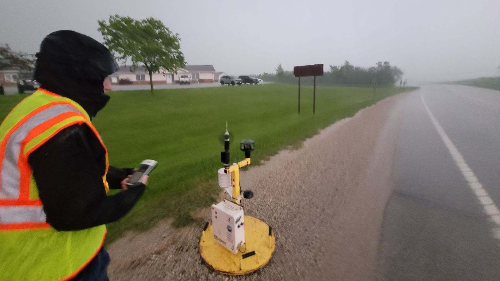
“It was evolving too quickly,” Kosiba told me. One DOW raced to get about 10 miles out, while Kosiba’s DOW truck tried to get closer — and Jen Walton and colleagues went even closer to the tornado, attempting to drop a Pod. Pods are placed in the projected path of the tornado, with the hope that they will obtain surface wind observations from within the radius of maximum winds. Positioning the Pod was difficult with a storm moving at close to 45 mph. 

“As we drove back west toward Greenfield … it was absolutely pouring, making it difficult to make out any features of the tornado-producing storm entering town. But as we pulled up and began to deploy the Pod, the rain bands took on a left-to-right motion indicative of rotation,” said Walton. “That’s when we knew we were in the bear’s cage — chaser slang for the mesocyclone portion of a supercell where a tornado can typically be found, if there is one. As we took GPS coordinates and prepared to depart, debris began falling slantwise out of the rain. We knew it was time to go.”

As it turned out, the Pod team wasn’t the only group having a close encounter. Kosiba’s DOW vehicle ended up directly in the path of a weaker tornado that was forming as they collected data near Greenfield. “The storm was going through a cyclic thing, and there was a new tornado forming very near us. It got windy and rainy.” Although they noticed this in real-time, there wasn’t much they could do except keep collecting data. Luckily, the tornado strengthened after it passed their location.  

As so often happens with this work, for Kosiba at least, there was no time even to be nervous. “Tornadoes are so fast, and you’re so focused on getting people in the right place, in a safe place, and getting the data, so there’s no time to think about anything other than that.” 

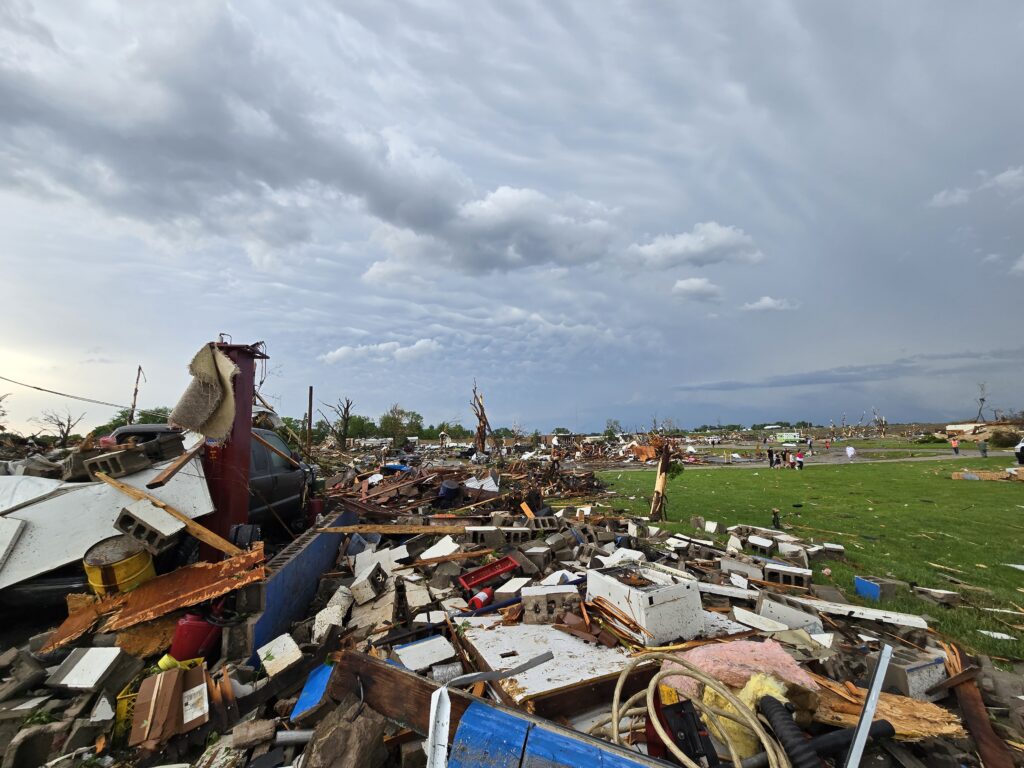
What was harrowing was driving into Greenfield once the tornado had passed. “There’s clearly a path of destruction … In that narrow region [where the tornado went through], it was pretty raked over. People were still coming out of their houses, animals were still trying to get oriented.”

Rare Data from a Disaster

The radar data from the BEST team is high-resolution enough that researchers will be able to examine how specific structures in Greenfield failed in the high winds. “Measuring low-level winds very close to a town is very rare … we can see in a very localized area what these structures experienced,” Kosiba said. These grim analyses could assist damage assessors after future storms, and perhaps even help those building and maintaining man-made structures to make them safer.

“We’re in the preliminary stages of inventorying what we’ve got and what we can do,” said Kosiba. “But it’s a rich and unusual dataset.”

DOW8 in Greenfield
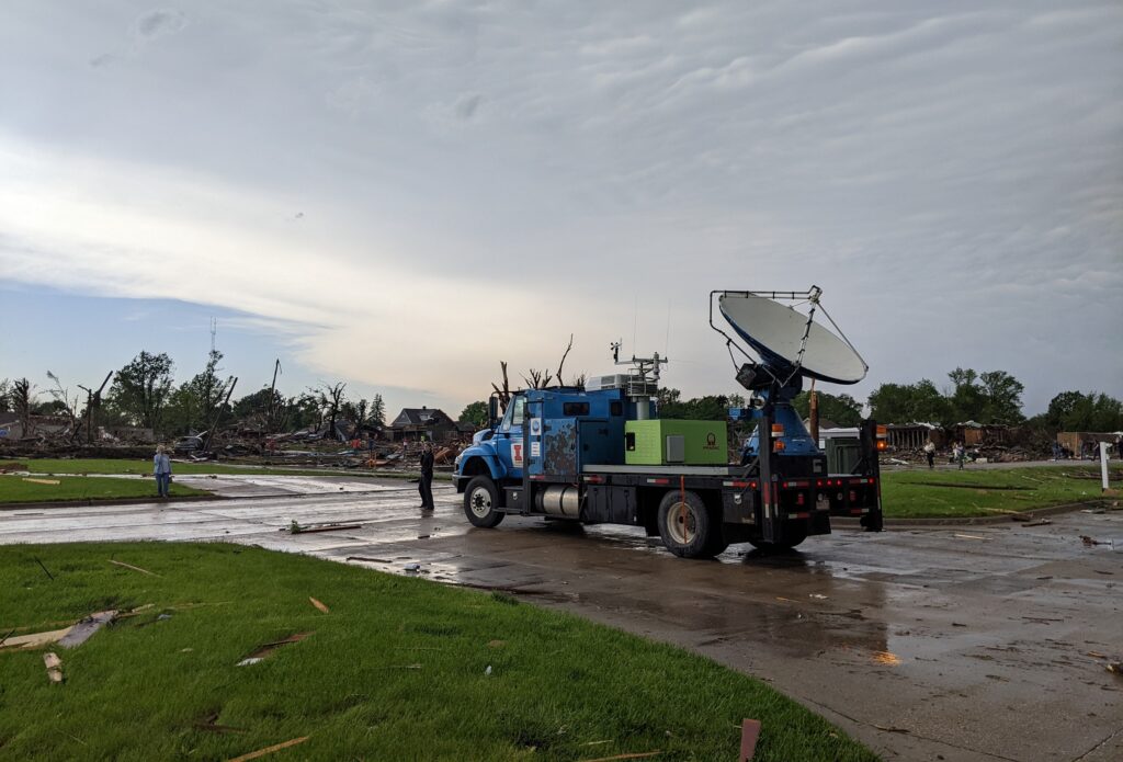
DOW8 vehicle in Greenfield after the tornado’s passage. Photo credit: Maiana Hanshaw/FARM Facility.

Strongest Winds Ever?

During the storm, the team was concerned only with acquiring good data. When they actually looked at the Greenfield readings, however, they were surprised to note winds of around 270 miles per hour, with gusts well above that. These one-second wind speeds are difficult to pinpoint exactly, said Kosiba, as the particles measured by radar — “debris, raindrops, grass, two-by-fours” — are all moving differently through the air and at different angles to the radar beam. “We’re trying to give a range, which puts this event at 309–318 mph.” The two strongest known tornadoes, El Reno in 2013 and Bridge Creek in 1999, both had DOW-measured wind speeds within that range.

Yet the Greenfield tornado was “only” deemed an EF4 by the National Weather Service (indicating three-second wind speeds up to 200 mph). This is likely because the EF scale is based on the structural damage a tornado leaves, not radar/instrument measurements. To receive the highest rating, EF5, a tornado has to damage structures to a degree that only an EF5 could. “It’s possible there was nothing [in its path] that could have sustained an EF5 level of damage,” said Kosiba. 

In addition, the highest wind gusts measured by the DOW team were for very short intervals, often less than one second, rather than longer-period averages. Due to the relative dearth of close-up measurements, we don’t know enough to say how unusual such high wind speeds near the surface really are.

Chasing the Data

“Twisters,” the long-anticipated sequel to the 1996 movie “Twister,” has hit movie screens, highlighting the awe of dangerous storms–and the divisions sometimes drawn between scientific researchers and those who chase storms because it’s their passion. As researchers and storm chasers who work together to get vital information about tornadoes, what do Kosiba and Walton think?

Jen Walton deploys a Pod of weather instruments in the path of the Greenfield tornado. Photo credit: BEST/FARM Facility.

“In my opinion, storm chasers are fonts of historical knowledge and expertise that are underutilized by the scientific community, and this is something I’m discussing with AMS and the broader research community,” said Walton. “We get a bad rap for being adrenaline junkies seeking our next thrill, and of course some folks are. But many people, myself included, would love to have more tangible ways to contribute in addition to already serving as eyes on the ground for the National Weather Service and/or working with local broadcast meteorologists. When Karen mentioned the opportunity to support the BEST Project, I jumped at the opportunity to use my own knowledge and expertise to contribute to work I know will truly make a difference in peoples’ lives – and even though my 2024 looked very different than a typical season, my time in the field with the DOWs is an experience I wouldn’t trade.”

“This kind of data collection is high risk but high payoff. You have to be out in the field to do it,” said Kosiba. “People who storm chase can make very valuable parts of the scientific team. Jen knows storm structure and forecasting … We want people who know what they’re looking at, who can think about exits; they need to be able to make some autonomous decisions out there. … If you just have a textbook understanding of storms, you have to get ramped up [on the practical side]. But people who’ve been looking at these storms for a long time and making decisions, that’s a great skill.”

To learn more about Girls Who Chase, listen to podcast interviews with experts like Dr. Kosiba, or even start your storm chasing education, check out girlswhochase.com.

To learn more about BEST and the DOWs, AMS Members and Weather Band members can watch our 23 July, 2024 webinar featuring Drs. Kosiba and Wurman and moderated by Jen Walton: Tornado on the Ground: DOW insights from 2024 tornadoes, including the Greenfield, IA EF4.

Recreational Tornado Chasing: the Psychology of Risk

Who seeks the thrill of nature at its most beastly? Researchers at the University of Missouri’s School of Natural Resources surveyed people who sign up for tornado chasing with five different tour companies in Tornado Alley and found that:

  • 62 percent are male
  • 63 percent were single.
  • The mean age was almost 42.
  • More than 25 percent had an advance degree.
  • 33 percent earn more than $100,000 per year
  • More than half are visiting from outside the United States: one-third from Europe, 13 percent from Canada (although one company cooperating in the study chased in Canada), and 11 percent from Australia.

We know that chasing is a hobby that is hard to shake. Not all these tourists are newbies: 53 percent had previous chasing experience and fewer than half of those had done so with a tour company, yet over 30 percent of those with chasing experience had seen a tornado before. 68 percent said they would be willing to spend money on another chase tour.
In a Master’s thesis based on the study, Shuangyu Xu builds psychological profiles of people based on “sensation-seeking” scales of behavior that might identify motivations for chasing tornadoes (asking questions about, for example, predilections for strange foods, comfort with people who are different, and predilection for restlessness). Previous studies had used similar psychological tools to investigate mountaineering, sky diving, white water rafting, and other high risk recreation. The storm chasing tourists scored very moderately on these tests for sensation-seeking behavior.

[H]ang-glider pilots (Wagner & Houlihan, 1994), mountain climbers (Cronin, 1991), skiers, rock climbers, white water kayakers, and stunt flyers (Slanger & Rudestam, 1997) displayed high levels of sensation seeking across all dimensions. These results may suggest that recreational storm chasers are different from other risk recreation activity participants, especially because their personalities seem to be more drawn to new experiences rather than the risks involved.

The tourists professed to sign up to be near nature, to witness natural power and beauty, and to learn about tornadoes. They were not generally doing it to impress people or do something extraordinary, and only moderately interested in the thrill, danger, or risks.
About half of the tourists were able to see a funnel cloud on their trip (and almost 35 percent saw a tornado on the ground). Interestingly, though, while nine companies originally agreed to distribute surveys to customers, four ultimately did not, citing inadequate weather and challenging economic conditions. Maybe the real risk takers here are not the tourists but the tour operators, who put their financial well-being at the mercy of both the business climate and the weather.