With most of us focusing so much on the weather in our hometown, it can be easy to forget that a local weather event can exert global influence. But given recent events in New York City and Panama, it appears that Mother Nature has been trying to reinforce that point.
The post-Christmas snowstorm that hammered much of the eastern United States produced chaos for travelers in a number of states, but it was the 20 inches that fell in New York City that had the farthest reaching impact. The closure of all three NYC metro airports caused a ripple effect that spread across the country and throughout other parts of the world. Not only were throngs of holiday travelers stranded at terminals in New York, but more than 5,000 domestic flights–as well as many in other countries–were canceled and countless more were backed up for days while waiting for LaGuardia, JFK, and Newark airports to get up and running. So, for example, more than 200 flights were canceled at Chicago’s O’Hare and Midway airports solely because of the East Coast snow, disrupting the plans of thousands of travelers even though the blizzard was hundreds of miles to the east.
(Aside 1: What could be a better use of your time when stuck in a snowstorm than this cool time-lapse video shot during the blizzard in the New Jersey shore town of Belmar…)
(Aside 2: There’s that old meteorologists’ adage, “Nobody lives at the Airport”, which happens to be the title of Larry Heitkemper’s presentation at our Seattle meeting, Wednesday 26 January. Heitkemper discusses how to transform official airport observations into data relevant to energy demand where people actually live; apparently, however, when blizzards strike far too many people really do live at the airport.)
Meanwhile, heavy rains last month in Panama forced the Panama Canal to close for just the third time in its 96-year history. Torrential rainfall inundated parts of Central and South America throughout November and early December. Two artificial lakes (Gatun and Alhajuela) in Panama that flow into the canal rose to record-high levels, forcing the canal to close for 17 hours so that one of the lakes could be drained. While the closing was short-lived, the global effects were still significant. About 5% of all international trade utilizes the canal, with approximately 40 ships winding through its 48 miles each day. While sections of the canal have been blocked at times, it was the first time the entire canal was closed since the United States invaded Panama in 1989. The only other closures were caused by landslides in 1915 and 1916, not long after it first opened.
snow
Snow for Alabama: Can the Models Do the Talking?
Alabama hasn’t had a lot of luck with White Christmases. In Birmingham, for instance, it’s only dusted snow once, and that wasn’t an actual measurable accumulation.
It’s no wonder then that the prospect of snow tomorrow has sent chills of excitement down the spines of Alabamans who have had their eyes glued to the computer models this week.
On his AlabamaWx blog, ABC 33/40 broadcast meteorologist James Spann and Tim Coleman have been trying to temper excessive expectations for days now, even while trying to patiently explain the promising but multifarious model output. On Wednesday, for instance:
There is very little skill in forecasting winter storm events in Alabama until you get with about 48 hours of the event. Nobody knows the exact snow placement and amount this early. Even the know-it-alls don’t know, even though they will never let you bebutlieve it (those of us that have been doing this a long time professionally have had enough doses of humility over the years to be firmly out of the know-it-all camp). We can begin talking accumulation placement tomorrow when that 48 hour window opens up.
and:
The NAM and the GFS, the two primary American models, show very limited moisture, and not much more than a dusting of snow for the I-20 corridor. The deepest moisture will be over the southern half of the state, where initially the precipitation will fall in the form of rain.
The ECMWF and the GEM, the European and Canadian models, are a little more bullish on moisture for North Alabama, but it is still limited. Both of these models suggest enough snow to get 1/2 to 1 inch on the ground. Which, if happens, would be historic for Birmingham. Up north, everybody would completely laugh at the fuss this is creating.
All this talk about what the computers say apparently gets a violently different reaction from folks depending on the stakes. Therein lies a lesson in communicating with science as we approach a meeting devoted to the topic. Wrote one commenter yesterday on AlabamaWx:
Yeah I’m.pretty upset that one.minute the models are right on for a winter storm then the next it flakes out. It literally crushes a lot of peoples wants and all but atleast we did have a chance a day ago! Now its all a good memory.
Just the day before, Spann wrote:
I am amazed at the angry tone of e-mails this evening… some are simply livid that I am not predicting a big Christmas day snow storm that would be historic for Alabama. I will probably never understand why winter weather brings out such passion and emotion. Seems to be more intense every year. Never was like this in the “old days”… one guy called me an “idiot of historic proportion” because “his forecast” was for 6 inches of snow for Birmingham. Wow.
Apparently, despite the cool dispassion of mathematics and computers, it is actually easier for people to rant at computers churning out uncertainty than
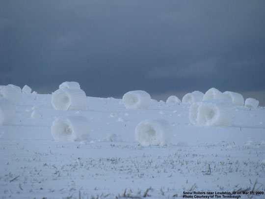
Snow Rollers
Thanks to George Taylor (Applied Climate LLC) for pointing out excellent photos of snow rollers taken in 2009 by Tim Tevebaugh in Lewiston, Idaho, Here’s just one of several that can be found at the NWS-Spokane website:

.
Taylor’s blog provides a good description of the phenomenon.
Looking for Snow in Atlanta?
Northeasterners and those from colder climates visiting Atlanta may be trying to escape the snow during the Annual Meeting. But for those who aren’t, there’s a place nearby to play. Stone Mountain Park’s Snow Mountain, Atlanta’s first snow park, is a virtual winter wonderland.
The park includes a tubing hill and a 30,000 square foot play area, filled with a blizzard of snow activities. Although the manufactured snow is icy compared to the fluff that occasionally falls in Atlanta, the warmer air temperatures allow for more comfortable outdoor play.
Originally planned to open in 2007, the park was widely criticized for its plans to use one million gallons of tap water during a drought. The plan was changed to use water from the park’s own lake and the park opened last year.
December East Coast Snowstorm a Cat. 3
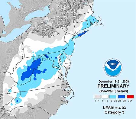
Memories of the pre-Christmas snowstorm that paralyzed travel across megalopolis in mid December might not be as fresh as the severe cold snap that kicked off the new year east of the Rockies. But the storm, which dumped 1-2 feet of snow on the Mid-Atlantic, earned a Category 3 ranking on the Northeast Snowstorm Impact Scale, known as NESIS, classifying it as a “major” winter storm.

NOAA’s NESIS ranks Northeast snowstorms on a five-tier scale ranging from Category 1 “Notable” to Category 5 “Extreme.” It characterizes the storms based on how much snow falls (must deposit at least 10 inches); the size of the area affected, and the population of the impacted area. Developed in 2004 by renowned winter weather experts Louis Uccelini and Paul Kocin, both with the National Centers for Environmental Prediction, catalogs snowstorms dating back to 1888.
“Last month’s storm was one of only five in the past decade that ranked Category 3 or higher,” says Kocin. The others: December, 2002 (Category 3); February, 2003 (Category 4); January, 2005 (Category 4); February, 2006 (Category 3), and February, 2007 (Category 3). Topping the NESIS scale—and the only winter storms rated Category 5—are the “Superstorm” on March, 1993 and the “Blizzard of ’96” in January, 1996. Last month’s snowstorm fell short of the higher NESIS rankings for several reasons, explains Uccelini.
“While snowfall from the December storm ranked in the top ten for Washington, Baltimore and Philadelphia, the storm only provided a glancing blow to the New York City and Boston metropolitan areas and overall affected a relatively small area. This led to it being classified as a Category 3,” he says.
Although NESIS is the only snowfall index being used operationally by NOAA, there are NESIS-like indices being developed for other parts of the nation. At the AMS Annual Meeting in Atlanta, a presentation by Michael F. Squires (Wednesday, 20 January, 2:00 PM, B211) will discuss the Development of regional snowfall indices.
Addtionally, David Robinson of Rutgers University will introduce a new climate data record of satellite-derived snow cover extent in his presentation Northern Hemisphere snow cover extent during the satellite era (Wednesday, 20 January, 10:30 AM, B218).
Harsh Cold Wave Slowly Retreating
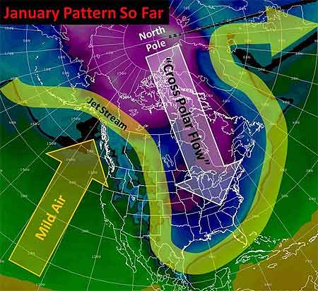
Well, the big winter cold snap that has been gripping much of the United States since December is nearing its end. Temperatures in most places from the Plains to the East Coast have started to rebound and no renewed surges of Arctic air are on the horizon after a final weak front moves through the East Tuesday. But the damage is done in places from the Dakotas and Montana to Florida: burst pipes, roads that drifted shut, and wind chills lower than -50 in the North, and car crashes on icy roads, power outages, and record cold that has chilled the South.

Last Thursday, the wind chill in Bowbells, North Dakota hit 52° F below zero. That degree of cold “freezes your nostrils, your eyes water, and your chest burns from breathing — and that’s just going from the house to your vehicle,” said Jane Tetrault of Burke County. Her vehicle started, but the tires were frozen. “It was bump, bump, bump all the way to work with the flat spots on my tires,” she said, adding, “It was a pretty rough ride.”
Snow and icy winds whipped southward from the Midwest into Tennessee, Georgia, and Alabama late in the week, making travel a disaster in Memphis and Atlanta. Video of cars sliding off roads or into each other played every half hour on The Weather Channel into the weekend.
Even the Sunshine State had wintry precipitation with this unusual cold surge—something not seen in more than 30 years. The weekend into Monday was especially brutal by Florida standards. With temperatures in the 30s and low 40s, light rain enveloped the peninsula Friday night through Saturday. Sleet fell in spots from Jacksonville and Ocala southward through Orlando, Tampa, and Melbourne into Palm Beach. A few wet snowflakes mixed in here and there with snow reported by trained spotters as far south as Kendall, a southern suburb of Miami. In some places north of Tampa, enough sleet accumulated on cars and outdoor furniture to build little “sleet” men, complete with tiny hats and tree-twig arms, their photos rivaling those taken of snowmen built in Tampa on January 17, 1977. (View a of Florida sleet from a snow and ice slideshow on Tampa’s baynews9.com.)
Clearing led to record morning lows both Sunday and Monday that threatened harm to Florida’s $3 billion citrus industry. Temperatures bottomed out at 25° in Tampa, 29° in Orlando, and 31° in Ft. Myers. On Sunday, the temperature in Miami tied the 1970 record for the date with 35°, and a 36° low Monday morning broke the previous record for the date of 37° set in 1927. Despite the records, it has been the duration of the cold, especially in the South, that makes this cold snap memorable. Morning after morning since the previous weekend, photos of Florida strawberries encased in ice showed up on newscasts. Such protective measures against the frigid temperatures are expected for several more mornings in central Florida, even as the chill slowly moderates.
The cold was even long-lasting in the Midwest and Plains, as noted in TWC meteorologist Tim Ballisty’s article “It’s Cold But So What?” last week. He points out that Chicago hasn’t been above freezing since Christmas Day, at the time 11 straight days and counting. Cleveland had 10 consecutive days of snow, and that count continued right into the weekend.
Unlike the extensive heat waves of recent summers, this long and harsh cold snap resulted in relatively few new temperature records. At the Annual Meeting in Atlanta, Gerry Meehl of NCAR will explore the rising ratio of record high temperatures to record low temperatures, which is expected to markedly increase by the middle of the century with current projections of climate warming.
An Inconvenient Snow
Next week on Friday (11 December), 7 p.m. Central Time, the University of Texas-Austin will present a live Webcast of “Global Warming—Lone Star Impacts,” a lecture by Gerald North ofTexas A&M.
It should be an interesting occasion, not just because North is an experienced scientist and climate change is a hot topic, but also because of the timing. The lecture was supposed to be delivered this past Friday, yet an unseasonable snowstorm got in the way. Ah, the inconvenient truths of climate: day-to-day weather can be uncooperative.
As SciGuy blogger Eric Berger for the Houston Chronicle observes: “What does snow falling in Houston have to do with global warming? Nothing. Nada. Zip.” For emphasis, Berger also posted a great photo from a record Houston snowfall in 1895, not to be missed by history buffs.
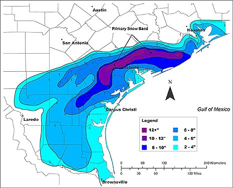
Friday’s storm across the Gulf Coast delivered the earliest snow on record for Houston–but just five years ago the region had a Christmas snowfall with depths of up to 13 inches.
Fortunately this week’s snow was lighter, but if you’re interested in a detailed perspective about how Gulf coast snow mechanisms can be surprisingly prolific and yet quite “ordinary”, check out the poster by Ronald Morales presented at the 2007 AMS Conference on Mesoscale Processes. It’s full of vivid satellite and radar imagery from the 2004 storm, as well as this overview of the snowfall.
