Real Estate Confronts Climate Change

Buildings on a Boston waterfront, silhouetted against a setting sun. Photo by Kristin Vogt on Pexels: https://www.pexels.com/photo/silhouette-photograph-of-buildings-near-calm-body-of-water-17632/

A 105th Annual Meeting Session Spotlight

By guest author Jacques Gordon, Director, Graaskamp Center for Real Estate, University of Wisconsin-Madison

Editor’s note: The “Panel Discussion in Climate Linked Economics: Navigating Climate Risks and Economic Shifts in Real Estate” takes place today, Monday 13 January, at 4:30 p.m. as part of the New Orleans Forum on Climate Linked Economics at the 105th AMS Annual Meeting.

My apartment in Boston’s Back Bay is just across the Boston Common from the AMS headquarters on Beacon Street.  Yet, when Brock Burghart invited me to speak at the Annual Meeting, I knew very little about the organization—its history, its journals, or its purpose.

In registering for the conference and exploring the AMS website, I reached a number of quick conclusions. 

  • Serious climate scientists and the broader world of weather fanatics all find a home at AMS.
  • The organization is committed to education, research, and networking.
  • I should join.

I have spent the last 40 years working in the field of real estate investment management on behalf of large institutions, like pension plans and sovereign wealth funds. Then, more recently, I joined two universities (MIT and Wisconsin) to help teach the next generation of real estate practitioners. It did not occur to me that the AMS would be a place where I could learn something I wanted to know or contribute something that might be of interest to others. By attending my first meeting, I am hoping to find out if either proposition is true.

My participation is part of the research track entitled “Climate-Linked Economics.”  The panel I will serve on includes a risk management expert from Europe, a data scientist from Utah, and a housing data expert.  

The material I plan to share follows directly from several different experiences that I have had in the investment industry and academia.    

  • Fifteen years ago, I co-founded the climate risk task force at the large investment management firm where I worked. Our goal was to link up the work of our risk management specialists, our portfolio managers, our research teams, and our deal-vetting acquisitions department. After Hurricane Katrina hit New Orleans in 2005, we knew we had to pay attention.
  • Then, when I semi-retired as an “executive in residence” at MIT’s Center for Real Estate, I joined an interdisciplinary seminar with the grand-sounding name “The MIT Joint Program on Global Change.” This group of scientists from the Earth, Atmospheric and Planetary Science department also teamed up with economists and social scientists to model the long-term effects of climate change.
  • Finally, I recently moved to the Wisconsin School of Business, to lead its top-ranked real estate program and to make connections with faculty, alumni, and students.  One of my first initiatives was to meet with as many of the alumni of both MIT and Wisconsin in Southern California as I could. We picked Santa Monica as our venue in mid-December of 2024. You can just imagine the dialogue over the past week between our alumni and the owners, developers, and financiers of residential and commercial real estate in this part of the world.

The massive move of American businesses and households to the sunbelt, where higher levels of climate risk are found, along with the increasing cost of insurance, and (most recently) the wildfires sweeping across the LA metro, all shape my views on how real estate and climate change intersect. Here are six take-aways that I plan to share with the AMS membership.

  1. Major weather events are costing property owners, the government, and insurers well over $1 trillion each year in the US. This is roughly equivalent to 4% of the national output of the country. Moreover, this estimate does NOT include the thousands of incidents of smaller (less than $1billion) weather-related damage that occur each year. Nor does it account for the rising cost of insurance—or the loss in a property’s value when insurance coverage is dropped.
  2. Mitigation efforts to reduce the carbon footprint of buildings—both their construction and their operation—are well underway. They vary tremendously—by jurisdiction, by owner and by type of property. In general, serious mitigation is found more frequently in new commercial construction, leaving most of the built environment—both residential and commercial buildings—in catch-up mode.
  3. Adaptation efforts are also well underway. These are vitally important, because climate scientists tell us that even if society could achieve a drastic drop in GHG emissions, more volatile weather is almost certainly already here to stay.  Adaptation efforts can also be expensive and not every owner or jurisdiction will be able to afford them.
  4. In the midst of all this change in the risk profile facing real estate, a data science revolution is going on. There is a gap between the large-scale weather models produced by NOAA and members of the AMS, and the risk analysis needs of the market. Put simply, the need is for micro-analysis of specific locations and different kinds of structures. Data vendors and consulting firms are innovating and putting out new products to meet the demand. Research done by the Urban Land Institute shows how this is a relatively new industry, with many of the unknowns associated with the launch of any forecast model.
  5. Large, well-financed property owners, and many of the world’s largest and wealthiest cities, are already deep into the process of assessing their climate risks and trying to figure out what to do about them. Organizations like the Securities and Exchange Commission (SEC) and the Federal Reserve are also ramping up their requirements for climate risk disclosures. There is a race going on—to see whether voluntary private sector efforts or government-led regulators are better suited to addressing both mitigation and adaptation challenges.
  6. Whatever side of this public-private divide you fall on, there can be no doubt that climate change raises challenges unlike any experienced in the world before. The temporal and geographic reach of climate risk is unprecedented in the history of humankind. It affects many more realms of human endeavor and the natural world than any prior policy challenge. The built environment is an important place to start tackling these challenges and growing our understanding of what it will take to address mitigation and adaptation simultaneously. Buildings are tangible and right in front of us. We live and work in them every day. We depend on them for leisure, for trade, for culture, and for industry. 

An acknowledgment that real estate is an important part of the climate change puzzle is not without controversy. Some real estate owners say that it’s up to the tenants, not landlords, to change behavior. Transitioning to sustainable energy can compete with other worthy goals—like bringing down the cost of housing or making cities affordable for all kinds of businesses and manufacturing. Some of the most in-demand types of properties—like data centers and life science buildings—consume enormous amounts of energy. And, the developed world still has to reckon with the claims of emerging markets that they should be compensated for their mitigation and adaptation efforts. Yet, as difficult as these problems are, there can be no doubt that real estate construction and operations have to change from “business as usual.” Real estate contributes one third of GHG emissions, globally. In the world’s major cities it contributes close to 70% of all GHG emissions in these metro areas. Alongside other basic economic sectors—including transportation, agriculture, and manufacturing—real estate must re-assess its role in society and how it can be a net contributor to decarbonization instead of a net contributor to global warming.

Photo at top: Buildings on a Boston waterfront. Photo by Kristin Vogt on Pexels.

Defining Derechos Is Complicated–Even for Meteorologists

Derechos are less common than Midwestern tornadoes, but occur almost every year in that region as well as other parts of the United States. Yet they remain exotic and mystifying. Even to meteorologists.

The reason appears to lie in the complex way the long-lived windstorms form. Derechos are often incorrectly referred to as inland hurricanes; their damaging winds can reach hurricane force, but they are straight-line in nature, rather than circulating around a common center. When people suffer, though, they can be forgiven for using the wrong windstorm term. By definition derechos have to meet specific criteria, such as causing damage continuously or intermittently in a lengthy line of at least 400 miles that’s at least 60 miles wide. But just like hurricanes, they come in a variety of intensities.

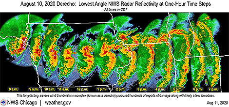
2020_derechoLast week’s derecho, roaring 750 miles from eastern Nebraska across Iowa, Illinois and Indiana, was particularly ferocious with winds in multiple swaths across Iowa gusting to over 100 mph. The National Weather Service found damage to an apartment complex in Cedar Rapids, Iowa, consistent with wind gusts of an astonishing 130-140 mph. But even these extreme winds and the severe damage they wrought don’t tell the whole story of the variation in these windy storms with the seemingly odd name.
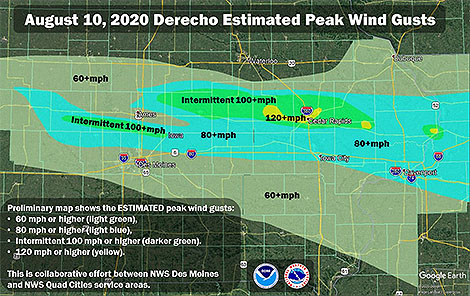
Iowa_wind_gustsThe AMS Glossary of Meteorology states: “The term derecho derives from a Spanish word that can be interpreted as “straight ahead” or “direct” and was chosen to discriminate between wind damage caused by tornadoes, which have rotating flow, from straight-line winds.” It defines derechos as widespread convectively induced straight-line windstorms.

Specifically, the term is defined as any family of particularly damaging downburst clusters produced by a mesoscale convective system. Such systems have sustained bow echoes with book-end vortices and/or rear-inflow jets and can generate considerable damage from straight-line winds.

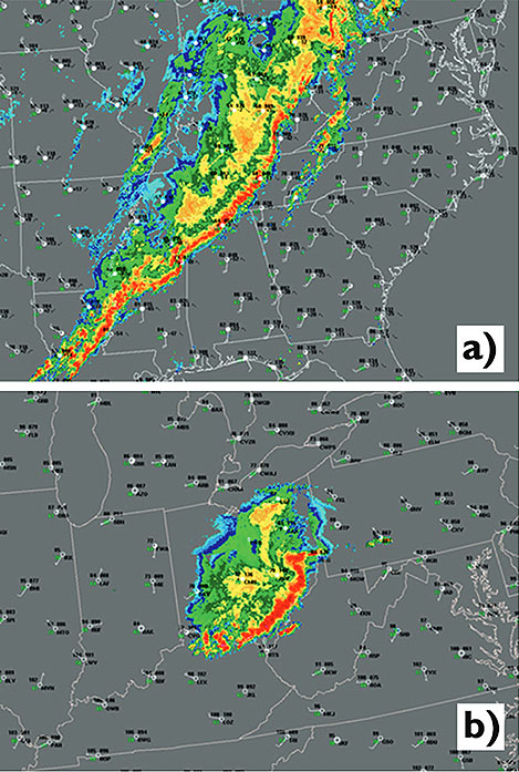
Two very different derechos: Base reflectivity composite radar data for (a) 2056 UTC 4 Apr 2011 and (b) 2234 UTC 29 Jun 2012, with surface observations plotted using conventional station plot format. Convective system in (a) is composed of a series of loosely connected, largely linear bands with low-amplitude LEWPs, whereas that in (b) consists of a single, intense arc of storms with a well-defined bow echo. Animated radar and satellite imagery for these events may be viewed at http://spc.noaa.gov/misc/AbtDerechos/casepages/apr042011page.htm and http://spc.noaa.gov/misc/AbtDerechos/casepages/jun292012page.htm.
Two Very Different Derechos: Base reflectivity composite radar data for (a) 2056 UTC 4 Apr 2011 and (b) 2234 UTC 29 Jun 2012, with surface observations plotted using conventional station plot format. Convective system in (a) is composed of a series of loosely connected, largely linear bands with low-amplitude LEWPs, whereas that in (b) consists of a single, intense arc of storms with a well-defined bow echo. Animated radar and satellite imagery for these events may be viewed at
http://spc.noaa.gov/misc/AbtDerechos/casepages/apr042011page.htm and
http://spc.noaa.gov/misc/AbtDerechos/casepages/jun292012page.htm.


This updated definition was the work of a team of meteorologists about five years ago who compared different straight-line windstorms—all meeting the damage criteria of derechos at the time but clearly having different mechanisms driving them. Their published paper in the Bulletin of the American Meteorological Society was “A Proposed Revision to the Definition of ‘Derecho’.” With it, the authors made the case to improve the definition of derecho to make it more physically based and more closely mirror other definable meteorological terms such as tornadoes, extratropical cyclones, and cirrus clouds.

While the paper had a positive effect among the meteorological community, a web search still turns up different definitions of derecho among meteorological websites, including within the NWS.

We asked the lead author of the BAMS paper, Stephen Corfidi (NOAA NWS, CIMMS, University of Oklahoma), for his thoughts on last week’s Midwestern derecho, to put it in perspective and also to help explain the reasons behind the difficulty with meteorologists not only defining but using the meteorological term differently.

BAMS: Was last week’s Midwest fast-moving line of severe thunderstorms with damaging winds a derecho? If so, did it fit the Glossary definition of a derecho?

Stephen Corfidi: Last Tuesday’s Midwest wind storm met the AMS Glossary definition of a derecho. Most significantly, it satisfied the criterion for the presence of “one or more sustained bow echoes with mesoscale vortices and/or rear-inflow jets.” A large mesoscale vortex, located on the north end of the larger-scale bow-shaped convective system from central Iowa to Lake Michigan, appears to have been associated with some of the strongest and longest-duration surface winds that accompanied the event. While the swath of organized damaging winds was not particularly long (on the order of 500 miles (800 km)) in comparison to some past events, the length well exceeded the somewhat flexible 400-mile (~ 650 km) cut-off used to distinguish derecho storms.

BAMS: Among derechos, how does this one rank?

SC: The Iowa-Illinois storm is certainly one of the most memorable of 2020—a year that already has seen other noteworthy events (e.g., those in Colorado, the Dakotas, and Pennsylvania in June). What made the Iowa-Illinois event especially noteworthy was the sizable number of reliably-observed significant surface gusts. There were numerous reports in excess of 80 mph (35 meters/second), and incidental evidence that some locations experienced speeds greater than 100 mph (45 m/s). The strong winds—likely enhanced by the presence of the mesoscale vortex—in some places persisted for more than 30 minutes. The vortex to some extent resembled the “warm-core” (hurricane-like) circulation that formed within the Kansas-Missouri-Illinois derecho of 8 May 2009.

BAMS: What made this one stand out?

SC: The duration of the storm’s high winds over eastern Iowa and western Illinois—again, likely due in part to the presence of the large mesoscale vortex—was certainly outstanding. This is quite a statement considering that the event occurred in a region known for its propensity for derechos (Recall that Gustave Hinrich’s nineteenth century studies of straight-line wind events were based in Iowa).

BAMS: Why are derechos so perplexing and difficult for meteorologists to acceptably define?

SC: There are several reasons why derechos are not only difficult to define, but also challenging to forecast. Unlike supercell thunderstorms that, in most cases, are well-delimited in time and space, broad swaths of damaging convective winds can arise in many different ways. Some of the processes involved in derecho development remain poorly understood and / or are only partly resolved by current observational platforms.

More significantly, unlike weather phenomena like supercells, derechos may or may not be accompanied by meteorological structures that readily are apparent to human observers. For example, most meteorologists recognize a supercell when one appears in the sky. But specific cloud formations are not associated with derechos, and the characteristic meteorological structures that do accompany many derechos (e.g., embedded vortices and rear-inflow jets) are too large or subtle to be recognized by human observers without the aid of remote-sensing devices such as radar and satellite.

These same aspects make derechos difficult to forecast. One can say that derechos arise when a unique combination of known and unknown necessary ingredients is present over a sufficiently broad area to support rapid, repetitive, downshear thunderstorm development. That said, applying this concept in practice presents a formidable challenge. In some cases, the known ingredients are present, but the extent of the favorable environment is too limited for derecho status to be realized. Conversely, expansive environments sometimes appear that are supportive of widespread destructive winds, but not those strongly dependent on the smaller-scale processes associated with rear-inflow jets and mesoscale vortices.

As with any weather forecast, when “missed” derecho events occur, the root causes can be traced to the existence of too many unknowns—both observational and theoretical. In the case of derechos, both unknowns, at present, remain sizable.

BAMS: What has been the impact of your 2016 BAMS paper and proposed new definition?

SC: It does appear that the updated definition proposed in the paper has been adopted to at least some extent in the severe weather community; the updated definition in the AMS’ Glossary likely abetted the effort. There is, of course, no “official” arbiter of general meteorological terms.  This explains, in part, the range of derecho “definitions” that appear in some sources. The lack of consistency in the use of the term “derecho” was, in fact, a motivating factor in drafting the paper. We’d like to think that the paper focused needed attention on the value of increased precision in meteorological terminology, but that is not something that is easy to measure. It is probably safe to say that the definition of “derecho” will continue to change as the underlying processes responsible for the most intense storms become better understood.

BAMS: What would you like readers of your 2016 paper to learn about and from the re-defining of derecho?

SC: I think perhaps the most important take-aways are that (1) the existing definition was outdated because of the significant changes that have occurred in observational data, record-keeping, and understanding since the mid-1980s, and (2) that if we are to better understand and forecast high-wind-producing convective systems, we need to first better classify those systems that are observed.

BAMS: You and your colleagues at NOAA-NWS-NCEP put together a comprehensive and impressive website About Derechos. How did you become interested in them?

SC: Convective systems, in general, are interesting because there are so many “moving parts” involved in their development, sustenance, and motion. It is especially challenging—but also rewarding—to try to assess the strength and likely longevity of those processes in real-time so as to prepare useful forecasts. Derechos are high-impact events; they are one area where society would benefit greatly from increased meteorological knowledge.

BAMS: What was the biggest challenge you encountered in your work to update the derecho definition?

SC: Having thoughts on introducing any new idea is one thing, but putting those concepts into words is another. Unlike most other papers in our “business,” in this one I felt we had to be somewhat persuasive. I was not at first comfortable with taking such an approach. But the contrasts presented by the two derecho events introduced in the first part of the paper furthered my conviction that persuasion was needed to both defend and encourage discussion on the definition topic.

BAMS: What got you initially interested in meteorology?

SC: My interest in clouds and storms goes back to my earliest days as a young kid growing up in a house kept super-clean by my mom. Because I was forbidden to play in the yard when the grass was wet (I’d track dirt into the house, of course!), I soon came to appreciate “Mr. Sun.” In particular, I noticed that I’d often not see the sun the next day if certain cloud formations had appeared in the sky on the previous one. A bit later, in first grade, my dad introduced me to weather books in the local library. Some had cloud pictures indicating which formations were “bad,” and which were associated with good weather. I was hooked! Thunderstorm days were always a favorite because the clouds on such days seemed to change the most rapidly—and provided the most surprises. I was very interested in things like rocks and plants, too—but weather was always #1.

New Standard Aims to Improve Tornado, Severe Wind Estimates

By Jim LaDue, NWS Warning Decision Training Branch
For more than four decades, the go-to for rating tornadoes has been the Fujita Scale, and in the last eight years, the Enhanced Fujita Scale, or EF Scale. Soon, scientists and NWS field teams will have a new and powerful benchmark by which to gauge the extreme winds in tornadoes and other severe wind events.
The American Society of Civil Engineers (ASCE) has approved the EF Scale Stakeholder Group’s proposal to develop a new standard for estimating wind speeds in tornadoes. This standard will allow, for the first time, a rigorous process to improve not only the EF-scale but to adopt new methods to assign wind speed ratings to tornadic and other wind events.
The intent is to standardize methods. According to the ASCE blog, “The content of the standard would include improvements to the existing damage-based EF scale to address known problems and limitations.” ASCE went on to state that the data used for estimating wind speeds would be archived.
The EF Scale Stakeholders Group, composed of meteorologists, wind and structural engineers, a plant biologist, and a hydrologist, held a series of meetings over the past year to discuss methods available to provide wind speed estimations.  The consensus among the group is that many methods exist in addition to that used in the EF Scale today.  These include mobile Doppler radar, tree-fall pattern analysis, structural forensics, and in situ measurements.  The group also discussed ways that the EF Scale could be improved through the correction of current damage indicators and by adding new ones. The outcome of these discussions is available online.
The new standard will be housed under the Structural Engineering Institute (SEI) of the ASCE.  Users of the standard include but are not limited to wind, structural, and forensic engineers, meteorologists, climatologists, forest biologists, risk analysts, emergency managers, building and infrastructure designers, and the media.
Interested parties are encouraged to apply to the committee, selecting Membership Category as either a General member with full voting privileges or as an Associate member with optional voting capabilities. Membership in ASCE is not required to serve on an ASCE Standards Committee.
The online application form to join the committee is available at http://www.asce.org/codes-standards/applicationform/.
The new committee will be chaired by Jim LaDue and cochaired by Marc Levitan of the National Institute of Standards and Technology. For more information or questions about joining the committee, please contact us at james . g . ladue @ noaa . gov and marc . levitan @ nist . gov.

NWS Experiment Chooses Words To Improve Warnings

The National Weather Service recently announced plans to expand the use of its experimental impact-based storm warnings to include all 38 branches of the NWS Central Region. The warnings go beyond a simple explanation of a storm’s strength by communicating specific effects that the storm could cause, using descriptions like “major house and building damage likely and complete destruction possible,” “major power outages in path of tornado highly likely,” and “complete destruction of vehicles likely.” The warnings were implemented last year in Kansas and Missouri, and officials believe they helped prevent fatalities during a tornado outbreak in Kansas last April 14. The effectiveness of the warnings last year will be examined in more depth in a presentation at the Second AMS Conference on Weather Warnings and Communication, which will be held this June in Nashville (in concert with the 41st Conference on Broadcast Meteorology) .
These new warnings are just one example of the advances made in communicating dangerous weather events to the public, and the Nashville conference will examine a number of methods, including the use of social media and mobile apps. The meeting will also look at how the general public responds to various types of warnings, and explore both old and new technologies in warning systems. The full program for the conference can be found here.
Clarity of communication is a key to the impact-based warnings. According to this story in the Wichita Eagle, emergency officials are praising the vernacular of the new warnings. Michael Hudson, chief operations officer for the NWS Central Region headquarters in Kansas City, Missouri, noted that “emergency managers liked the extra information that was in the warnings–the information that got to the magnitude of the weather.” In specific reference to the intense tornado in Sedgwick County, Kansas, last April, that county’s emergency management director, Randy Duncan, felt the language in the impact-based warnings “helped to convey how serious the situation was, and the fact that we didn’t have any fatalities means–at least in my mind–that people in Wichita paid attention.”
The expanded use of the warnings this year will include some minor revisions resulting from some lessons learned in last year’s experiment. One change is the new use of the word “considerable” instead of “significant,” because “significant” was considered by many users to be too vague. Hudson explained that forecasters are instructed to consider “what you’d tell your wife or husband or children” about the potential threat of a storm.

Read more here: http://www.kansas.com/2013/04/07/2750867/use-of-impact-based-severe-weather.html#storylink=cpy


Read more here: http://www.kansas.com/2013/04/07/2750867/use-of-impact-based-severe-weather.html#storylink=cpy

Did Monday's Storm Set a Reporting Record?

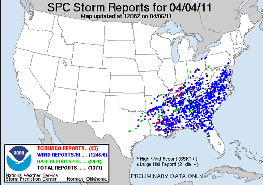
A storm system that stretched from the Mississippi River to the mid-Atlantic states on Monday brought more than 1,300 reports of severe weather in a 24-hour period, including 43 tornado events.
The extraordinary number of reports testifies to the intensity of the storm, which has been blamed for at least nine deaths, but it also reflects changes in the way severe weather is reported to–and recorded by–the Storm Prediction Center. As pointed out by Accuweather’s Brian Edwards, the SPC recently removed filters that previously prevented multiple reports of the same event that occurred within 15 miles of each other. Essentially, all reports are now accepted, regardless of their proximity to other reports. Additionally, with ever-improving technology, there are almost certainly more people sending reports from more locations than ever before (and this is especially true in highly populated areas such as much of the area covered by this storm).
So while the intensity of the storm may not set any records, the reporting of it is one for the books. According to the SPC’s Greg Carbin, Monday’s event was one of the three most reported storms on record, rivaled only by events on May 30, 2004 and April 2, 2006.

Monday's severe weather map