In a paradox that it seems only nature can muster—like quelling a year-long drought in the western two-thirds of Texas with record snows—it turns out that warming going on in the Arctic this winter is the likely culprit behind killer cold and snow that had been plaguing Eastern Europe since late January. And it is now also likely linked to the colder-than-normal winter occurring in Japan and Western Asia.
Weather patterns since the fall have set up in such a way as to leave large expanses of Arctic Ocean, particularly the Barents and Kara Seas north of Scandinavia and Russia, nearly ice-free. In fact, an image from early February posted to the Arctic Sea Ice Blog shows this area north of the Arctic Circle as open water for the first time in what it refers to as the “new Arctic regime (2005-present),” when it should be completely frozen over.
The changing weather patterns resulting from this new era of record sea ice melt seem to have helped build up a huge helping of frigid air over Siberia that came crashing southward as soon as the storm track shifted, which it inevitably does throughout the year. Instead of Western Europe like the last two winters, this time the bitter cold targeted Eastern Europe, delivering snow-laden storms to nations of the Eastern Mediterranean and even North Africa, as well as far Western Asia, Korea, and Japan.
Numerous researchers have been working the last few years to figure out what’s going on. The environmental news and technology site Bits of Science wrote a timely online article explaining the findings of recent published research and then tying the studies to the different teleconnections patterns that influence Eurasia’s winter weather — the Arctic Oscillation and its focused cousin, the North Atlantic Oscillation. Together, these pressure anomaly-driven climate patterns can dictate where winter’s worst cold and snow and best warmth become established.
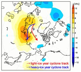
A new study headed for publication in the Journal of Climate in March further extends the influence of the warming Arctic. The article by the Research Institute for Global Change’s Jun Inoue et al. contends that the storm track over the Barents and Lara Seas takes a more northerly route when sea ice there is reduced. In a positive feedback mechanism, the northward-shifted storm track pulls warm air over the Arctic Ocean. At the same time, cold air builds over Siberia and the Norwegian coast, and becomes poised to spill southward, or to the west and the east.

“Such warm Arctic and cold continental conditions are referred to as a warm-Arctic cold-Siberian (WACS) anomaly, and the WACS anomaly could be a procurer of severe weather in the downstream region,” the authors report.
As with the collective research on the warming Arctic’s influence on mid-latitude winter weather, Inoue et al. conclude that using sea-ice variability from this region of the Arctic would improve the reliability of the seasonal weather predictions in individual years.