By Lourdes B. Avilés, Associate Provost, Plymouth State University
Tornado Warning, a Green Sky Story
It was the spring of 2001, during my time as a doctoral student in atmospheric sciences at the University of Illinois at Urbana-Champaign (UIUC). I was part of a team of teaching assistants that supported the introductory weather courses. We all knew that there was a possibility for severe weather on that day, but this was common in the spring, and we just went about our business.
During our weekly planning meeting, the weather radio sitting on a corner of the room went off with a tornado warning, which we mildly noted but ignored. This was terrible judgement, but back then the warnings were triggered if any part of a county was under the possible path of a seen or suspected tornado. Most of the time the presumed tornado was nowhere near our location. We were a bit desensitized, and we were busy; maybe you can give us the benefit of the doubt.
A minute later, however, one of our professors, the great Bob Rauber, came to the door of the room and said something like “If I was you, I would get out of here RIGHT NOW!” Our long-occupied temporary building had no secure areas to shelter, so we headed to the very large and sturdy nearby physics building.
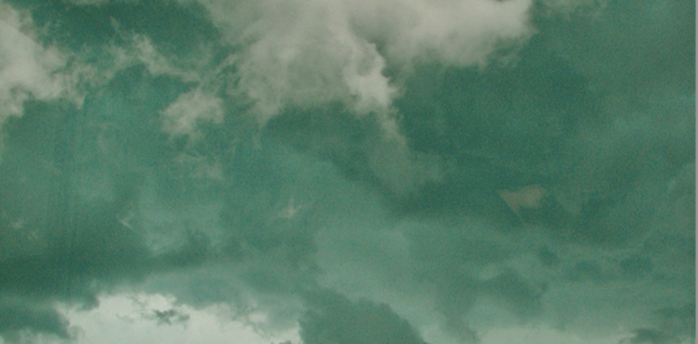
It was nearly 25 years ago, and the image is etched in my mind. As we left our unsafe building in a hurry, I looked up in awe at the unexpected sight of a green sky above and as far as I could see. There might have also been some hanging mammatus cloud accessories lining the underside of what must have been a large cumulonimbus cloud over us. It was strange and unsettling and nothing like I had seen before or since.
I remember in slow motion our mass of meteorologists running toward safety (I always told my students, “If you see the meteorologists running away, you should probably run with them.”). We made it to the basement of the physics building and somebody loaded the radar loop on somebody else’s office computer. This was before we could look at radar images on a cell phone, also why I have no pictures of the amazing green sky. On the computer screen, you could see the radar signature of a supercell thunderstorm, a hook echo, moving straight toward us. A hook echo tells us that there is a rotating thunderstorm capable of producing a tornado. If there is such a tornado, it will be right inside the hook. As soon as it came at us, however, it loosened into an elongated blob, like an opening meaty claw. The thunderstorm passed through with no tornado in the downtown area. There was, however, one confirmed touchdown about a mile north, closer to where my husband and months-old baby were at home. Thankfully, everyone was OK in the end.
This was a favorite story of mine to tell the Severe and Hazardous Weather students as a meteorology professor at Plymouth State University in New Hampshire. I had a worksheet with tornado myths and facts, including one about the sky turning green when a tornado was coming (a myth!).
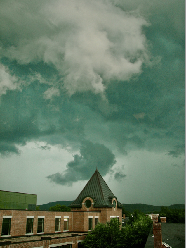
Since then, I have seen a green sky only one more time (the one depicted in the photo below). That one was not a dramatic story — simply watching a severe thunderstorm through the window of the Weather Center at Plymouth State. The sight, however, was still awe inspiring.
Green Skies during Severe Thunderstorms: an Introduction
The occasional greening of the sky during large strong thunderstorms is a well-known phenomenon, at least to severe weather enthusiasts, and can gain some notoriety once in a while. In early July 2022, for example, a derecho that moved roughly from Montana through South Dakota and into Iowa produced a flood of green sky photos on social media and news sites, as well as articles attempting to explain the phenomenon.
The green light might be observed right above in the sky (as in my own photo below) or under distant thunderstorm clouds. There is not always a tornado when the sky is green and there is not always a green sky when there is a tornado. However, the effect seems reserved for particularly large and strong thunderstorms. For some time, green sky thunderstorms were considered an optical illusion of sorts (a perception trick), or as maybe the reflection of a nearby green surface. The greening, however, has been unequivocally proven by objective optical measurements.
The explanation of how a thunderstorm turns green has been somewhat elusive, and there are many incomplete or outright inaccurate explanations out there. Basic atmospheric optics concepts, however, can allow us to come up with enough pieces of the puzzle for a satisfactory understanding.
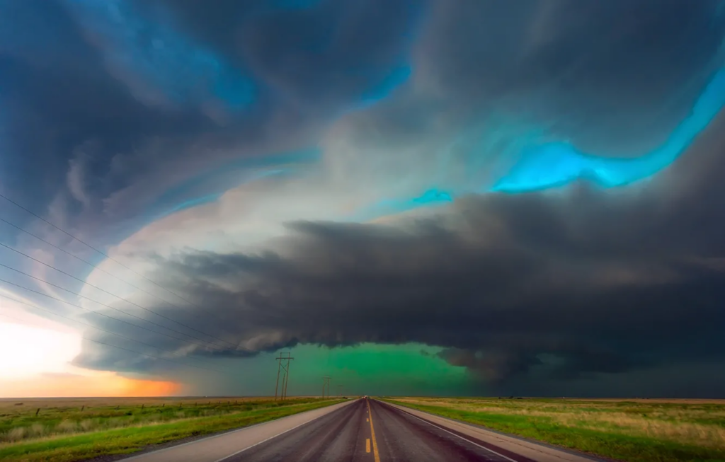
Image: A stormy sky and clouds that would normally be blueish gray or charcoal show instead a green tint. This photo could be suspected of manipulation to obtain the green colors, but — while it has been slightly color-enhanced to match what was seen — it was taken by the author, who witnessed the green sky from a Plymouth State University Weather Center window on July 18, 2008. The pictured green is quite persistent — still noticeable on reduced saturation of all colors, or even reducing the green saturation while increasing the blue saturation. No matter what, it still looks green. Photo by Lourdes Avilés.
The Color of Things
Before going into that exploration, it is worthwhile to very briefly overview different ways in which objects and matter can be colorful. Our eyes detect visible light of different wavelengths that are ultimately interpreted as colors. Each color is associated with a specific wavelength within a continuum that goes from approximately 400 to 700 nanometers (nm). Shorter wavelengths closer to 400 nm correspond to violets and blues, while longer wavelengths closer to 700 nm correspond to reds, following the familiar ROY G BIV “colors of the rainbow” order. Regardless of how the specific wavelengths of light were produced, our eyes and brain interpret the colors that reach our eyes accordingly. We should also remember that all wavelengths together are seen as white, while the absence of all visible wavelengths is interpreted by our visual system as black.
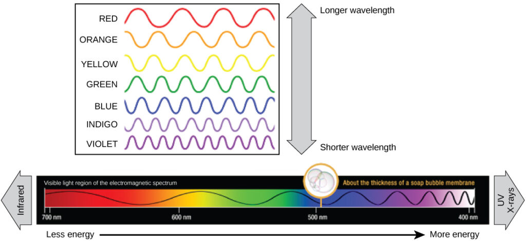
The visible portion of the electromagnetic spectrum, including wavelengths between 400 and 700 nanometers, includes a continuum of colors that range from the shortest and most energetic violets to the longest and least energetic reds. Image courtesy of Wikimedia Commons.
Refraction — for example, through a classic glass prism — disperses white light into the colors of the spectrum. This occurs with a variety of atmospheric optical effects, for example, rainbows and some ice halos. In those cases, the entire visible spectrum is revealed.
Objects like a red ball, a green leaf, or a yellow crayon, on the other hand, owe their specific colors to selective absorption of visible wavelengths. Our eyes will only see the colors that are NOT absorbed. In the case of the red ball, for example, only the reds are reflected/scattered for us to see, while all the other wavelengths are absorbed.
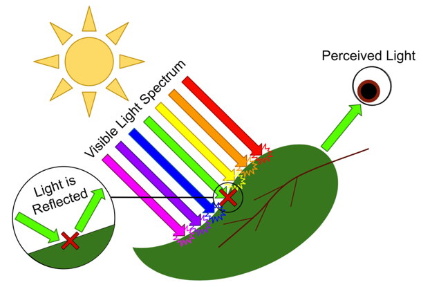
This is a very simplified illustration of how objects have color. The leaf absorbs all colors except for green, which is reflected/scattered for observers to see. Image courtesy of Wikimedia Commons.
Another important color-producing process in the atmosphere is the scattering of sunlight by air molecules. In an interplay between the size of light waves and the size of air molecules, we get what is called Rayleigh Scattering. Short visible wavelengths like violets and blues are scattered much, much better than the longer ones. This is why the sky is blue, as scattered blue light comes to the observer from all directions in the sky. There are also the emissions by individual gas molecules when returning to a less excited state. This is what produces, for example, the light of the aurora. Incandescent emissions (also known as blackbody radiation) due to high temperature can also be within the visible spectrum. This is how we see the surface of the Sun or a lightning bolt.
There are more fascinating mechanisms that can create light and specific colors but are not relevant to our current discussions — for example, lightning bugs and other bioluminescent creatures rely on chemiluminescence, which occurs when chemical reactions emit light. For those willing to take on a technically detailed text, I recommend Nassau’s, “The Physics and Chemistry of Color: the Fifteen Causes of Color.”
Ok, but what about the green skies? Let us reason our way through it first and then check in with a handful of experiments and scientific articles related to the topic that have been published over the last few decades.
The Setup
A perceptibly greener-than-normal sky is visible in these thunderstorm cases, meaning that more green light is detectable than expected. Air or water droplets would need to be heated to hundreds or thousands of degrees in order to emit such light directly, so that is not the cause. Higher up in the atmosphere, atoms and molecules might absorb energy due to energetic solar particles and emit light — such as the green light of the aurora. But in the troposphere, where thunderstorms form, encountering such energy sources is unlikely, and even if happened, the air is dense enough that the energy would be instantaneously lost to collisions with other air molecules rather than emitting light.
The air and droplets are also not green as a leaf is green, since there is not a pigment such as chlorophyll absorbing other wavelengths and reflecting the green; but this idea brings us a little closer to a scientifically accurate explanation for our green sky. Light on both sides of the visible spectrum is somehow being depleted or at least diminished, and the wavelengths in the middle are the ones available in excess for our eyes to see (and detectors to detect). Now we can start making a few educated assumptions.
Severe thunderstorms often happen in the late afternoon or early evening, after warming of the atmosphere by solar radiation provides enough energy. The actual “severe” designation — based on whether the storm produces sufficient winds or large enough hail, or forms a tornado — matters less to us than the fact that it is a very large thunderstorm that contains large amounts of water (in any or all its forms).
These large clouds are thick enough to fully or mostly block direct sunlight and diffuse skylight coming straight from above. This means that the light that can be seen under the cloud comes from farther away, traveling a longer path through air molecules in the atmosphere.
Storm clouds can also contain good amounts of large water droplets and possibly growing hail moving within the strong updrafts and collecting supercooled water droplets.
The information above helps explain why the opposite sides of the visible spectrum of colors are diminished, leaving an excess of green for our eyes to see. The likely culprits are 1. Rayleigh scattering of short wavelengths by air molecules and 2. absorption of long wavelengths by water molecules. Let’s take a moment to examine the two.
Rayleigh Scattering’s Contribution to Green Thunderstorms
As noted above, Rayleigh scattering of incoming sunlight by air molecules produces the blue of the sky, as shorter wavelengths are scattered much more strongly. During sunrise and sunset, as sunlight travels a much longer path through the atmosphere, blue wavelengths are scattered away before they can make it to our eyes, leaving only the longer wavelengths which are less strongly scattered. This explains orange/red sunsets. The same effect occurs during a solar eclipse, when overhead light is blocked by the shadow of the moon.
A thick cloud blocking the light coming from above can act similarly to an eclipse, meaning that the light we see comes from farther away — and has had a chance to lose some of its blue to scattering before it reaches our eyes. If the storm happens in the late afternoon, with the sun low in the sky, the effect is much more pronounced.
During a total solar eclipse, the shadow of the moon blocks diffuse sunlight from reaching the surface from above. The light is instead coming from farther away, leading to depletion of the shorter wavelengths (the blues). If not blocked from view, one might see sunset-like conditions all around, a 360° sunset. The photo, courtesy of O’Dea on Wikimedia Commons, was taken during the 21 August 2017 total solar eclipse at 11:45am local time in Orin Junction, Wyoming.
For green to be the observed color instead of red/orange, however, the longest wavelengths must also be preferentially removed. That role is played by water.
Light Absorption by Water Molecules’ Contribution to Green Thunderstorms
Water molecules — whether in water vapor, liquid, or ice — have a slight preference for absorbing the longer wavelengths of the visible spectrum, certainly more than the shorter ones (see the graph below, which shows light absorption by water). There is much more to it, but the difference in absorption is enough so that if light is reflected/scattered many times within a water-molecule-containing feature like a storm cloud, the depletion of long wavelengths can be noticeable.
Light has traveled a long way through the air to get to us as we observe this hypothetical dark, late-afternoon storm; its blue wavelengths are depleted by Rayleigh scattering. Now, as it illuminates a cloud from below, the light also starts losing some of its red as it is reflected/scattered around many times by the droplets and hail within or underneath the storm cloud. With longer red wavelengths diminished, and with shorter blues not available to dominate, greens are more visible.
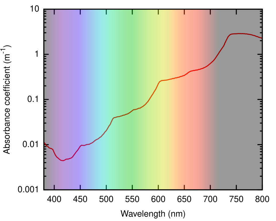
This graph shows the absorption (or absorbance) coefficient–how much of a wavelength is absorbed–for visible light and adjacent wavelengths (380-800 nanometers) moving through pure water at 22°C. Public domain data, plot, and data sources available from Wikimedia Commons, contribution by Jonasz (2007).
The time of day, size of the cloud, the ability of light to shine on the cloud from below, the size and amount of water droplets and hail, and other environmental conditions will cause variability in the intensity, possibly the hue of the green, or even our ability to see the phenomenon at all during a strong thunderstorm.
Scientific Studies and Other Ideas
Over the past half-century only a handful of published scientific articles have directly addressed the explanation for green thunderstorms, as for example, Bohren and Fraser (1993), Gallagher et al. (1996), Gallagher (2000), and Gallagher (2001) and some of the references therein. Some persistent folk explanations of green thunderstorms were shown by these studies to not explain (or not fully explain) the phenomenon. Here are a few, and why they do not work:
Reflections from green vegetation have been suggested. Green light is detectable from green vegetation as one would expect, but there is not enough, and sometimes not even of the same wavelength as the thunderstorm green being observed. Additionally, green thunderstorms have been seen over terrain that has no green.
Another often-cited idea is that it is the presence of hail that provides the green. There is some value to this explanation as the ice will absorb the long wavelengths, leaving the greens to dominate in an already blue-depleted light, but the explanations often incorrectly speak of scattering of light being the reason, as if the large hail scattered green preferentially, which is most definitely not the case. Hail is simply too large to scatter wavelengths preferentially. The water molecules in hail will indeed aid red absorption, but the presence of hail is by no means necessary. The large volume of small supercooled water droplets within the cloud can have much more red-wavelength absorbing potential, and so does the intense precipitation under the cloud. Most hail-inducing thunderstorms tend to be normally colored and not green.
One final and very persistent idea is that the very dark cloud allows the perception of green in blue-depleted light. This would be similar to the way in which a faraway mountain looks blue, as the Rayleigh scattering in between the observer and the mountain provides blue light superimposed on the dark mountain sight. Blue-depleted late-day light would show as green, so there would be scattered green light between the clouds and the observer. This idea is scientifically sound, mainly for faraway thunderstorms, but would not work well when the thundercloud is right above. Sources that first proposed this explanation also emphasized the mind’s perception of green against a dark background, and rejected the notion that there is actual green light coming off the cloud or the precipitation—perhaps not considering the red absorption by water molecules. This latter idea is often found as THE explanation of green skies when one seeks online information, but even though it might be part of the story, it is by no means enough to account for observations. Additionally, direct measurements of light coming off clouds during greening events have been made, proving that the observed green matches actual green light from clouds and precipitation.
This freely available photograph, though likely color-enhanced, very clearly shows an intense green color associated with the precipitation under a thunderstorm cloud. It also shows in the background that the timing of the photo was close to sunset, and that the sky above is blue. The light coming from far away during sunset has lost its blue, while the light coming from much closer is still scattered blue light. The presumably strong precipitation under the cloud has absorbed long wavelengths in the blue-depleted sunset light, leading to the observed green.
Summarizing
After the plentiful explanations above, it is perhaps wise to add a short summary. Intense thunderstorms (with very large clouds and large amounts of water) sometimes become green in color. The reduction of the short wavelengths, the blues of the spectrum, is due to Rayleigh scattering during the long path of light through the atmosphere toward the observer. The reduction of the long wavelengths, the reds of the spectrum, is due to absorption by water (in its various frozen and liquid forms within the cloud and/or as precipitation). The middle visible wavelengths, the greens, are then able to dominate. Other environmental conditions and perception aspects might additionally help the observer to see the green color, but are not necessary or sufficient to produce the effect.


