Severe but highly variable wind damage to homes & infrastructure is a hallmark of intense tropical cyclones. Until recently there was only speculation that such damage, which appears in short swaths, was the work of tornadoes. Now, there’s first-ever proof that tornadoes and other small-scale phenomena did indeed enhance the winds and damage in Hurricane Harvey last August.
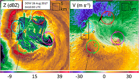
Doppler of Wheels (DOW) radar in the eye of Harvey revealed mesovortices (MVs) rotating swiftly around the inner eyewall, and embedded in them and documented for the first time were small tornado-scale-vortices (TSVs) less than a half-mile wide spinning within the larger wind field of the hurricane. The discovery was reported in March in a paper published in Monthly Weather Review.
The rotation of the TSVs is weaker than typical supercell tornadoes, but because these circulating winds are embedded in an already extreme eyewall, they ramp up the wind speed and create greatly enhanced damage potential, says the study’s lead author Joshua Wurman of the Center for Severe Weather Research. In Harvey, major hurricane winds of about 120 mph ramped up to 130-140 mph or more and resulted in streaks of severe damage not evident elsewhere from the eyewall winds.
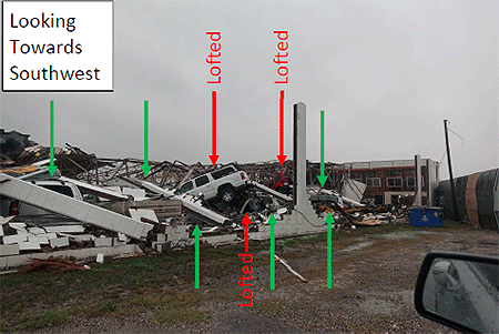
“Wind gusts at the DOW site were measured up to 145 mph, likely caused by a TSV, and 30% of the vehicles parked near the DOW were lofted,” Wurman wrote in a summary of the paper to appear in a forthcoming issue of the Bulletin of the AMS. A Jeep and two SUVs were picked up by the wind and landed atop debris from the destroyed building in which they were housed. He said the swaths of intense damage corresponded to the tracks of the eyewall TSVs.
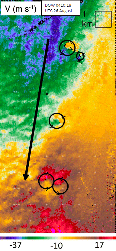
Doppler velocity data reveals single and paired TSVs (black circles) translating southward in Harvey’s northwestern eyewall embedded in strong northerly flow (black arrow). These TSVs, moving southward at up to 120 mph, were associated with very intense winds measured up to 145 mph, lofted vehicles, and swaths of the most intense building damage.
Wurman and co-author Karen Kosiba, also with CSWR, will present their research findings from Hurricane Harvey as well as newly identified evidence of at least one Harvey-like TSV in Hurricane Irma over Florida at the 33rd AMS Conference on Hurricanes and Tropical Meteorology next week in Ponte Vedra Beach, Florida. The conference will feature a number of other presentations on the devastating hurricanes of 2017, in multiple sessions (Session 1, Session 2, Session 3, Session 4).
Wurman notes that it’s unclear whether the new wind whirls are more numerous in intense or rapidly strengthening hurricanes. But adds that the enhanced damage was palpable, and with an increase in powerful hurricanes possible due to rising global air and ocean temperatures, it’s important to learn more about them, he says.
“Potential climate change may result in more frequent intense and/or rapidly intensifying hurricanes, thus understanding and forecasting the causes of hurricane wind damage is a high priority.”