Native American Heritage Month Spotlight: Robbie Hood

Robbie Hood

November is National Native American Heritage Month. In this post, we spotlight the exceptional career of one of our Native American community members: Robbie Hood.

Hood is an atmospheric scientist with over 30 years of experience at the National Aeronautics and Space Administration and the National Oceanic and Atmospheric Administration. She is a member of the Cherokee Nation of Oklahoma.

Can you tell us a few highlights of your current or most recent work?

I am a Cherokee meteorologist who worked with NASA and NOAA for a combined total of 30 years. Now in retirement, I am collaborating with NCAR personnel to explore how low-cost 3-D printed weather stations could be used by Indigenous communities for student training and tribal decision-making. I have also been collaborating with the Rising Voices Center for Indigenous and Earth Sciences to plan the program for the 2025 AMS Heather Lazrus Symposium to be held during the 105th AMS Annual Meeting in New Orleans. In this symposium, I will be moderating a panel discussion focused on cultivating tribal and community partnerships within the weather, water, and climate enterprise.

What was an important moment in your early career?

I started my meteorological career as scientific programmer, but I was given an opportunity to step out of my comfort zone at NASA. I became the project scientist for a new passive microwave aircraft instrument that could observe precipitation within thunderstorms and hurricanes. This move gave me the opportunity to work with and, eventually, lead teams of renowned scientists, engineers, and pilots during large international weather field experiments that were conducted in places like Australia, Brazil, Costa Rica, Cape Verde, and the Marshall Islands. Along the way, I got to fly through four different hurricanes, all because I initially stepped out of my comfort zone.

What is something you’re proud of professionally?

My experience leading weather field experiments led me to become the manager of a NOAA program to test the potential benefit of drones and remotely piloted aircraft for operational application. In this role, I was able to organize and fund a multi-million-dollar field experiment to test, for the very first time, the capabilities of a high-altitude Global Hawk remotely piloted aircraft that was controlled from a central command center in Virginia to fly over and observe the characteristics of hurricanes and tropical storms in the Atlantic Ocean and Gulf of Mexico. During these missions, relevant data were successfully sent in near-real time to meteorologists at the National Hurricane Center to assist in their forecasts. Later research studying the impact of Global Hawk data assimilated into weather prediction models demonstrated positive results.

Are there ways in which your Native heritage has influenced or enriched your career?

I credit my Cherokee mother for teaching me to listen closely to how people tell their stories and pay attention to their feelings and expressions as they talk. She thought this would help me better understand who they are and how things looked from their point of view. These skills have helped me build good working relationships and strong collaborations throughout my career.
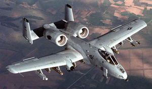
Plane Has Combative Attitude toward Storms

Technological advancements don’t always involve brand-new applications; sometimes, progress can be made when older technology is utilized in new ways. Such is the case with aircraft used for scientific research. “Experienced” military aircraft have proven to be effective for many types of atmospheric studies, and with the news (subscription required) that a powerful combat plane used by the military for many years is to be reconfigured and given a new assignment, many are looking forward to even greater research capabilities. Originally developed in the 1970s, the Fairchild Republic A-10 Thunderbolt II, better known as the “Warthog” or just “Hog,” is a twin-engine jet designed for close air support of ground forces. Now it’s being prepared to take on powerful storms.
For many years, the military plane of choice for research inside thunderstorms was the T-28. But as early as 1985, scientists recognized that this aircraft lacked the altitude reach, endurance, and payload capacity to adequately address many of their questions. After a number of workshops to study other options, the A-10 Thunderbolt was identified as a prime candidate to become the Next Generation Storm-Penetrating Aircraft.  A subsequent engineering evaluation confirmed the scientists’ view of the A-10 Thunderbolt, but the U.S. Air Force was resistant to authorizing the jet for civilian use. With the advent of the Center for Interdisciplinary Remotely Piloted Aircraft Studies (CIRPAS), a research center at the Naval Postgraduate School in Monterey, California, an opportunity opened to put an A-10 Thunderbolt into service of the civilian science community.  In 2010, the U.S. Air Force agreed to transfer an A-10 Thunderbolt out of mothballs to the U.S. Navy and, with funding from the National Science Foundation (NSF), and let CIRPAS (on behalf of the Naval Postgraduate School) operate it as it has operated a Twin Otter and other aircraft for the last 15 years. CIRPAS aircraft are equipped with basic meteorological, cloud, and aerosol sensors, and have ample capacity for additional instrumentation that collaborators from other universities or national laboratories may wish to use.

The A-10 Thunderbolt

The A-10 Thunderbolt must be completely reassembled to be prepared for atmospheric research. A main part of this effort is wing replacement, but other activity includes evaluation of reinforcement and engine protection needs. The jet will also have its nose-mounted, 30-millimeter cannon removed, opening up more space for scientific instruments. The aircraft is scheduled to be ready for flight in the fall of 2012 and for flying actual scientific missions by mid-2013.
So other than its name, what makes the A-10 Thunderbolt so qualified to fly into storms? Perhaps most importantly, its heavy armor, designed and built to withstand machine-gun and cannon fire. Most planes avoid cumulonimbus clouds and thunderstorms because the hazards that may be encountered inside such clouds–such as severe turbulence, severe icing, lightning, and hail–can be fatal. Encountering hail is particularly dangerous, as striking golf-ball-size hail at 200 mph can smash windshields and damage the airframe and engines. But the A-10 Thunderbolt is rugged enough to deal with such conditions. As Brad Smull of the NSF’s Division of Atmospheric and Geospace Sciences noted, “It turns out that being able to survive wartime flak has a lot in common with being able to handle a strong storm.”
Also valuable are the A-10 Thunderbolt’s flight capabilities. Much is still unknown about cumulonimbus and thunderstorms, and the A-10 Thunderbolt has the potential to reach parts of storms that were previously off-limits. While the T-28’s maximum flying altitude is about 4.5 miles (7 kilometers), the A-10 Thunderbolt can fly at altitudes of up to almost 7 miles (11 kilometers)–high enough to reach the icy heights of thunderheads and gather data on hail formation. It also has the ability to stay in storms for up to 3 hours, compared to about 1 hour for the T-28, and because the A-10 Thunderbolt flies relatively slowly–about 342 mph (550 kilometers per hour)–the data it collects should be of particularly high quality. It can also fly lower than the T-28, making it ideal for air-sea interaction studies, and its heavy payload will support lidar, radar, and other imaging systems.
Ultimately, the versatility of the A-10 Thunderbolt may prove to be its most attractive trait. For example, it might help  meteorologists understand what governs the evolution of a storm and its eventual severity; atmospheric chemists study how storms generate chemical species, transport material through the depth of the troposphere, and modify them in the process; atmospheric physicists investigate how clouds become electrified and how electrification may feed back to influence the microphysics and dynamics of storms; and scientists who observe storms using remote sensors (radars, lidars, satellite radiometers) and who try to predict storm evolution by use of models gather in-situ measurements to validate their observations.
[Portions of this post contributed by Haf Jonsson of the Naval Postgraduate School]