by Bob Henson, AMS Councilor and Chair, AMS Committee on Environmental Stewardship (ACES)
Those of us involved with climate change in our professional lives—researchers, educators, authors, students—often feel the need to “walk the walk” in a demonstrable way. AMS is one of the world’s premier organizations involved with peer-reviewed research on our changing atmosphere, so it’s only fitting that the Society is finding ways to demonstrate its environmental bona fides in its own operations. For example, AMS has been a leader this past decade in working toward “green meetings.” An upcoming BAMS article will feature some green-meeting highlights, and a summary can also be found in the “About AMS” section of the AMS website.
Just in time for the Society’s 100th birthday, AMS has now ensured that the electricity supply in its offices in Boston and Washington, D.C., is effectively 100% renewable. The Boston shift involved working with the nonprofit Green Energy Consumers Alliance (GECA), a spinoff of Massachusetts Energy that works to maximize the use of renewables in the state’s electricity supply.
AMS recently finalized a renewable two-year agreement (retroactive to January 2019) to purchase Class I renewable energy certificates (RECs) from GECA. These certificates are equal to the full amount of electricity consumed at the AMS buildings at 44 and 45 Beacon Street. Each certificate mandates the production of one megawatt hour of renewable energy, documenting where, how, and when the energy (in this case, wind energy) was produced. In 2019, energy providers in Massachusetts were required to purchase in-state Class I RECs for 14% of all electricity they generate, a percentage that goes up each year by 1%. When entities such as AMS also purchase Massachusetts Class I RECs, it further stimulates the market for clean energy. In other words, Massachusetts Class I RECs don’t simply buy green energy that is already government-mandated; they actually promote the creation of new green-energy supplies within the state.
AMS Controller Joe Boyd worked with the AMS Committee on Environmental Stewardship (ACES) to research options for renewable energy at the Boston building and shepherded the final agreement with GECA.
“Given the Society’s strong commitment to environmental issues, it was natural that we include 100% renewable electricity sourcing to our efforts to maintain a small carbon footprint,” says AMS Executive Director Keith Seitter.
In Washington, AMS leases office space within the headquarters of the American Association for the Advancement of Science at 1200 New York Avenue NW. This building’s electrical supply is also effectively 100% renewable, via RECs that are purchased through a Constellation New Energy contract for transmission and generation. (The RECs do not include electric distribution, and the building also uses a small amount of natural gas.)
“ACES continuously strives to promote the Society’s environmentally progressive standards, complementing the research and efforts of AMS members. Thanks to felicitous timing, the Society is celebrating its transition to 100% renewable energy on its 100th anniversary,” says incoming 2020 ACES Chair C. Todd Rhodes (Coastal Carolina University).
So, Just What Do “Sunny” Southern California Broadcast Meteorologists Do?
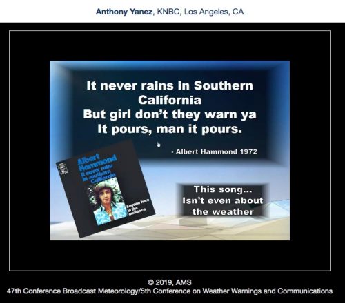
You know the perception: It never rains in Southern California, so forecasting the weather there is easy. Not so fast, says Anthony Yanez of KNBC TV in Los Angeles.
In his recent presentation at the 47th Conference on Broadcast Meteorology in San Diego, titled “Forecasting Southern California: Not as Easy as you Think,” Yanez takes a lighthearted yet very serious look at the myriad weather and other natural phenomena that threaten the state every year. These include heavy flooding rains, high winds, wildfires, mudslides, earthquakes, and hail. As station scientists, Southern California weather broadcasters must cover them all for viewers, and well. “I think that the science is a lot more … cuz everyone thinks the weather’s boring … when we do science, they love that. And they eat it up.”
So, Just What Do "Sunny" Southern California Broadcast Meteorologists Do?
You know the perception: It never rains in Southern California, so forecasting the weather there is easy. Not so fast, says Anthony Yanez of KNBC TV in Los Angeles.
In his recent presentation at the 47th Conference on Broadcast Meteorology in San Diego, titled “Forecasting Southern California: Not as Easy as you Think,” Yanez takes a lighthearted yet very serious look at the myriad weather and other natural phenomena that threaten the state every year. These include heavy flooding rains, high winds, wildfires, mudslides, earthquakes, and hail. As station scientists, Southern California weather broadcasters must cover them all for viewers, and well. “I think that the science is a lot more … cuz everyone thinks the weather’s boring … when we do science, they love that. And they eat it up.”
Peer Review: A Foundational Component of Our Science
by Keith L. Seitter, CCM, AMS Executive Director
This week we join many other scientific publishers celebrating Peer Review Week to highlight the importance of high-quality peer review in the scientific process. The process of peer reviewing research results has been an indispensable component of the modern scientific enterprise: when scientists talk about having reached a consensus in some area of research, they mean that there is a consensus in the peer-reviewed literature. This week gives us an opportunity to focus on the importance of peer review while also recognizing the dedication of researchers around the world who make considerable commitments of time to ensure its continued success while usually receiving little or no explicit credit for those contributions.
When a researcher submits a manuscript presenting research results to a high-quality journal like those AMS publishes, the editor of the journal selects several experts in relevant specialties to review of the manuscript. These experts make sure the author(s) have carried out their experiments, observations, and/or analysis following sound practices and that their conclusions can be justified from the data and analysis they have provided. In their reviews, these experts identify weaknesses or flaws in experimental design or reasoning and suggest additional research and analysis that might be required, as well as other ways to improve the paper.
The editor collects these peer reviews and determines if the manuscript can be made suitable for publication. If the science is flawed and the paper cannot be made acceptable with a reasonable amount of additional work, the paper is rejected. More than one in three manuscripts submitted to AMS journals are rejected. The editor’s decision is provided to the authors, along with the full set of reviews with the names of the reviewers removed (unless the reviewer chooses otherwise), along with the editor’s decision. If the paper has not been rejected, the authors follow the guidance of the editors and reviewers to revise the paper, which then may face additional peer review under the editor’s direction. If the paper can reach the point that the editor is satisfied with the quality of the work, the manuscript is accepted for publication.
Peer review, even when implemented in the rigorous manner used by AMS, is not perfect, of course. Occasionally important research is initially rejected in peer review, or fundamentally incorrect research survives peer review to publication only to be shown later to be incorrect. Peer review done well, however, greatly reduces the chance of publication of poor or incorrect science, and experience has shown that overall the process is extremely successful. That is why scientists depend virtually exclusively on results presented in rigorously peer-reviewed journals and why major scientific assessments—like the reports from the Intergovernmental Panel on Climate Change (IPCC)—rely on peer-reviewed literature from well-established, high-quality journals like those published by AMS.
Astute readers will have noticed that I refer to “high quality journals” multiple times above. It is important to make that distinction because there are journals vying for authors’ papers (and the income they provide) that do not put the time or expense into doing peer review with the rigor employed by the AMS journals. Authors, and the scientific enterprise itself, are best served by those journals that invest the resources needed to do the peer review to the highest standards. AMS journals enjoy membership in the elite group of such high quality journals that serve the atmospheric and related sciences.
Let me close with note of appreciation for those who maintain the very high standards of peer review for the AMS journals. While the professional staff at AMS does a wonderful job of ensuring smooth and expedient reviews, as part of a positive author experience that is among the best in scientific publishing, it is the volunteers who serve as chief editors, editors, associate editors, and reviewers who dedicate the time and energy to maintain the AMS journals as world-class publications. And the reviewers especially deserve credit given that their efforts are, by design, mostly done anonymously for the collective good of science. All of us owe these dedicated individuals our thanks.
Report: Hurricane Michael Upgraded to Category 5 at Landfall
2018’s devastating Hurricane Michael struck the Florida panhandle at Mexico Beach and Tyndall Air Force Base in October at Category 5 intensity with 160 mph winds, the National Hurricane Center announced Friday. That’s 5 mph higher than Michael’s wind estimate of 155 mph at the time of landfall.
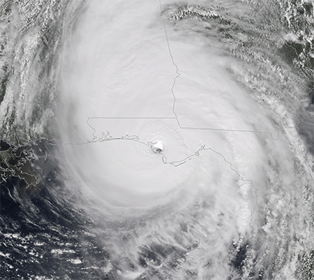
In its post-storm tropical cyclone report, released the same day, NHC stated it culled an abundance of wind data measurements not available in real-time to add the 5 mph to Michael’s wind intensity. The data came from aircraft reconnaissance, ground observations, satellite intensity estimates, surface pressures, and Doppler radar velocities from Eglin Air Force Base and the NWS in Tallahassee. The report goes in-depth with the data, explaining the observations and identifying those that were believable—a 152 knot (175 mph) aircraft wind measurement at 8,000 feet in the southeast eyewall that yields a surface wind of 137 knots (158 mph)—versus those that were suspect—a 152 knot (175 mph) surface wind measured by the stepped frequency microwave radiometer (SFMR) instrument aboard a different aircraft, deemed too high based on experience with such intense winds in hurricanes Irma, Jose, and Maria in 2017.
The upgrade makes Michael only the fourth Category 5 hurricane to hit the United States, joining a small, elite group of monster landfalling storms that include Hurricane Andrew (1992, 165 mph winds), Hurricane Camille (1969, 175 mph winds), and the Labor Day Hurricane (1935, 185 mph winds). Andrew plowed into South Florida, Camille landed on the Mississippi coast, and the Labor Day Hurricane devastated the Florida Keys.
(Photo courtesy: Chris Cappella [AMS])
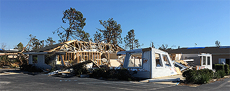
Hurricane Michael roared ashore on October 10 as the strongest hurricane on record to strike the Florida Panhandle, with a storm surge around 14 feet above ground level, destroying Mexico Beach and much of Tyndall AFB, while tearing apart homes and businesses in Callaway, just inland, as well as in the eastern side of Panama City. Sixteen people died directly from the hurricane due to storm surge flooding and the intense winds, which blew down entire forests in the panhandle and destroyed crops across southern Georgia. Wind damage extended into the Carolinas.
Very few surface observations of the hurricane’s intense winds were made at landfall. The highest gust was 139 mph measured by an anemometer at Tyndall AFB before it failed. Two coastal monitoring program towers measured 129 mph and 125 mph, substantially lower than the upgraded wind speed at landfall. One of the towers was knocked over before the peak winds struck, and the other was outside the hurricane’s core. NHC notes that the sites “were likely not optimally located to sample the maximum winds, which is typical during landfalling hurricanes.”
AMS on the Air Podcast: Alexandra Cranford Talks about Women in TV Meteorology
The largest biographical study to date of TV meteorologists shows some disturbing disadvantages for women in the profession. You can hear Alexandra Cranford, the author of that study, discuss the study on the latest episode of our podcast, AMS on the Air.
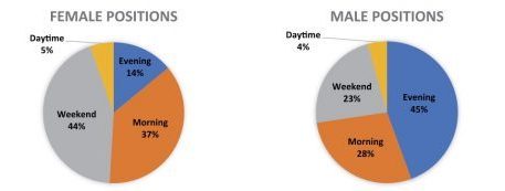
Cranford, who is an AMS Certified Broadcaster with WWL-TV in New Orleans, made an exhaustive survey of online information for more than 2,000 weathercasters. She focused on the relation between her colleagues’ professional status and education. The results, which formed the basis of her BAMS article, show women meteorologists have made gains on local TV, yet are not proportionately well represented in the most prominent and prized positions on local stations.
For example, women are much more likely to be on TV during daytime, mornings, and weekends, than on prime time slots:
And they are far less likely to be chief meteorologist for their station:
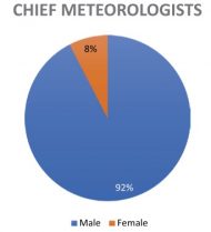
In the podcast interview, she speculates on some of the reasons for these findings.
Perhaps when a hiring manager is interviewing a man versus a woman as a weathercaster, they are looking at slightly different criteria….Another thing is, maybe women are choosing for some reason…perhaps to work maybe weekends and mornings. Maybe women are staying away from those chief positions for some reason. I have no idea if this is the case—I’m just throwing out ideas here—but…possibly due to family reasons or personal preference. That could maybe be another thing.
Also, women may choose to exit the industry earlier in their careers, so that leaves a pool of mainly older, more experienced, mainly males to fill those chief spots, which are typically filled by an older, more experienced person.
And then, one of the reviewers of my study brought my attention to the effect that all of us think about—but how much of a real effect might it have?—the effects of criticisms of consultants and social media and so forth. We all know about the internet trolls. Anyone who works as a TV weathercaster, I’m sure has gotten emails from viewers….That’s a very real thing too. There is research that suggests maybe that’s a bit worse for females versus males. Maybe that can play a role as well.
Listen to the whole interview on the AMS website or on your favorite podcast app.
World Water Day: An Integrated Appreciation
Wow! It’s World Water Day, as observed by the United Nations. Pretty much everything AMS is about has to do with water—from raindrops to atmospheric rivers to thunderstorms and hurricanes on to ocean currents and groundwater.
Which is why this concluding paragraph from the AMS Policy Program’s recently released study, “Toward an Integrated Approach to Water,” hit home and hits hard for us.
Water is simultaneously a resource and a threat. It is centrally important to every aspect of socioeconomic wellbeing and water becomes a hazard when there is too much, too little, or if the quality is poor. The ever-changing, increasingly human influenced water regime is characterized by localized, uncontrolled, intermittent, and sometimes huge flows of water (fresh and salt) across coastal zones, urban and rural areas, transportation infrastructure, agricultural resources, and through waterways. Earth observations and science provide critical environmental intelligence that help us determine when there is too much water, too little, or of the wrong quality. Services help us manage risks and realize opportunities that environmental intelligence makes possible. Decision-making with respect to water, as with all societal choices, has the greatest chance to benefit people when grounded in the best available knowledge & understanding.
Uncontrolled..intermittent…huge…too much…too little…An unflinching assessment from Paul Higgins, Yael Seid-Green, Andy Miller, and Annalise Blum. Read the whole report here and take in the full flow of interrelated issues that we, as an AMS community, must grasp in knowing and dealing with Earth’s ways.
International Women’s Day: Unsilencing the Forgotten Pillars of Meteorology
In the pages of scientific history, one often hears too much silence. A science–especially meteorology–is built by women who are rarely, if ever, remembered, let alone credited.
So maybe on this International Women’s Day, and more broadly, for Women’s History Month, let’s look back in the pages of history at the dedication to meteorology that women have always shown. Consider the dedication to a very essence of science—observation—shown in this item tucked into the January 1929 BAMS:
MRS. MORGAN IS POINT BARROW OBSERVER
When the Weather Bureau announced in the fall that radio weather reports were beginning to come in from our northernmost station, Point Barrow, Alaska, at latitude 71°…nobody would have guessed that the observer at this coldest and most inaccessible station, 450 miles north of other radio weather outposts, is a young woman, Mrs. Beverly A. Morgan, wife of the Army Signal Corps radio operator at the trading post there. …Mrs. Morgan and her husband live in the most primitive surroundings with only a few score people within hundreds of miles. Their only communication with the outside world, with the exception of their radio, will be a steamer once and sometimes twice a year. Occasionally even this powerful icebreaker is unable to penetrate to the post for months after her scheduled arrival. Shortage of food and other supplies has often caused serious handicap at the station, necessitating rationing of food. The temperature averages 19° F. below zero during the coldest winter months, and has been known to reach 55° below zero. Despite these hardships, Mrs. Morgan has pledged herself to make the routine observations twice a day regardless of weather, storms, sickness or other conditions. Many of the instruments require considerable mechanical attention and Mrs. Morgan is performing these duties in addition to her work as observer. The arduous observing is of great importance to cold wave forecasting in the United States, for Charles L. Mitchell, chief forecaster of the U. S. Weather Bureau in Washington, D. C., has found, by studies of reports for earlier years received by mail from this station and others, that the great invasions of cold air that sweep over much of the North American continent come in most frequently off the Arctic Ocean north of Alaska and are first observed at Point Barrow. Thus the reports from Mrs. Morgan will probably give us warnings of the approach of cold periods in winter some days earlier than heretofore.
And let’s listen to the commitment of one Mrs. Ross Morgan, a noted Weather Bureau Cooperative Observer, as recorded in her address to an AMS meeting in Nashville, Tennessee, later published in the January 1928 BAMS:
DUTIES AND EXPERIENCES OF A COOPERATIVE OBSERVER
By MRS. ROSS WOODS, Cooperative Observer, Palmetto, Tenn.
For years it has been my desire to have a convention of the weather observers of our state, that I might meet my fellow cooperatives and exchange experiences with them, but such a convention up to this time has not seemed feasible.
But now two mighty luminaries in the scientific world are in conjunction and with their combined attractive force, are drawing all the earth, great and small, toward them. The American Meteorological Society, for the first time in its history, and the American Association for the Advancement of Science, for the second time in its history, are met in our capital city. Truly opportunity is at the high tide of the spring tide and my erstwhile dream for years of too little importance to warrant fulfillment, is now a reality.
And now that I have the opportunity to speak, my heart fills so with emotion the words are choked back and with Tennyson I cry, “And I would that I could utter the thoughts that arise in me.” That little latticed shed, or instrument shelter, in the yard back home does not seem to me to house mere instruments of wood and metal. Those instruments are a part of my family and as dear to me as some cherished heirloom to another. And why shouldn’t I love them when I recall the days that used to be?….
At first I loved them because of my father, later for their own sake or shall I say because through association with my own babies they became almost like one of the children. For more than twenty-two years they have stood in my yard with the pride of their thirty-eight years of unbroken record which…had stood until last summer I was absent for ten days and not even the most insistent S.O.S. could secure a substitute.
How very, very often, I have the pleasure of showing a visitor or newcomer the maximum and the minimum thermometers, how they keep their register till I set them, explain the way to measure the rain, of keeping a daily record and noting the direction of the wind and character of the day, all of which must be made out once a month and sent to the Weather Bureau at Nashville. Usually this information calls forth words of appreciation and commendation, but there are some who are wont to ask, “Why do you do all this for nothing?” The easiest reply is: the compensation the Government could allow for this work would be small yet there are many incompetent and irresponsible persons, who would take it for the price, small though it be. But the truest and best reason is deep within my heart and could not be understood by a disinterested listener.
In fancy I stand before the instrument, not at the time I set the thermometer and make my daily record, but this is the hour before bedtime and this is my observation; above me is the sky “that beautiful parchment on which the sun and moon keep their diary….I see it “sometimes gentle, sometimes capricious, sometimes awful, never the same for two moments together, almost human in its passions, almost spiritual in its tenderness, almost divine in its infinity,” and I am glad I am numbered even though in a humble way among those who scan the sky.
Yes, we will remind readers of the exploits of the first woman to earn a Ph.D. in atmospheric sciences, the late Joanne Simpson who also served as AMS president (for example, today is a good day to listen to Carol Lipschultz’s biographical presentation on Dr. Simpson, here). And we will remember the story of Ann Louise Beck, who earned her Master’s degree in our science in 1922 while being instrumental in pioneering the use of the Norwegian cyclone model in weather analysis and forecasting in the United States. Her review paper on what she learned from her fellowship year in Bergen was probably the introduction to modern scientific forecasting for many American meteorologists in her day.
But lets remember that despite the all-too-often silence of history, women have long been a pillar of meteorology. Because of course they were, even if the journals are mostly silent.
In Dr. Simpson’s words, when she accepted the AMS Rossby Research Medal in January 1983.
Women meteorologists can now stand on their own, without defensiveness—and soon without, I hope, the prefix “woman ” preceding “meteorologist.” They no longer need, want, nor should expect special treatment or attention. For this alone I’m very glad I’ve survived to this day. My receiving this wonderful, encouraging—though simultaneously humbling—recognition is not an anomaly, but on the contrary, is a harbinger. It says—loudly and clearly—to that increasing number of younger women contributing to our science that each of you can expect an opportunity comparable to that of your male colleagues to receive the recognition that you earn. I am confident, in fact, if I am accorded a normal life span, that I will be here to cheer for the next several of you when one of these great honors comes your way.
International Women's Day: Unsilencing the Forgotten Pillars of Meteorology
In the pages of scientific history, one often hears too much silence. A science–especially meteorology–is built by women who are rarely, if ever, remembered, let alone credited.
So maybe on this International Women’s Day, and more broadly, for Women’s History Month, let’s look back in the pages of history at the dedication to meteorology that women have always shown. Consider the dedication to a very essence of science—observation—shown in this item tucked into the January 1929 BAMS:
MRS. MORGAN IS POINT BARROW OBSERVER
When the Weather Bureau announced in the fall that radio weather reports were beginning to come in from our northernmost station, Point Barrow, Alaska, at latitude 71°…nobody would have guessed that the observer at this coldest and most inaccessible station, 450 miles north of other radio weather outposts, is a young woman, Mrs. Beverly A. Morgan, wife of the Army Signal Corps radio operator at the trading post there. …Mrs. Morgan and her husband live in the most primitive surroundings with only a few score people within hundreds of miles. Their only communication with the outside world, with the exception of their radio, will be a steamer once and sometimes twice a year. Occasionally even this powerful icebreaker is unable to penetrate to the post for months after her scheduled arrival. Shortage of food and other supplies has often caused serious handicap at the station, necessitating rationing of food. The temperature averages 19° F. below zero during the coldest winter months, and has been known to reach 55° below zero. Despite these hardships, Mrs. Morgan has pledged herself to make the routine observations twice a day regardless of weather, storms, sickness or other conditions. Many of the instruments require considerable mechanical attention and Mrs. Morgan is performing these duties in addition to her work as observer. The arduous observing is of great importance to cold wave forecasting in the United States, for Charles L. Mitchell, chief forecaster of the U. S. Weather Bureau in Washington, D. C., has found, by studies of reports for earlier years received by mail from this station and others, that the great invasions of cold air that sweep over much of the North American continent come in most frequently off the Arctic Ocean north of Alaska and are first observed at Point Barrow. Thus the reports from Mrs. Morgan will probably give us warnings of the approach of cold periods in winter some days earlier than heretofore.
And let’s listen to the commitment of one Mrs. Ross Morgan, a noted Weather Bureau Cooperative Observer, as recorded in her address to an AMS meeting in Nashville, Tennessee, later published in the January 1928 BAMS:
DUTIES AND EXPERIENCES OF A COOPERATIVE OBSERVER
By MRS. ROSS WOODS, Cooperative Observer, Palmetto, Tenn.
For years it has been my desire to have a convention of the weather observers of our state, that I might meet my fellow cooperatives and exchange experiences with them, but such a convention up to this time has not seemed feasible.
But now two mighty luminaries in the scientific world are in conjunction and with their combined attractive force, are drawing all the earth, great and small, toward them. The American Meteorological Society, for the first time in its history, and the American Association for the Advancement of Science, for the second time in its history, are met in our capital city. Truly opportunity is at the high tide of the spring tide and my erstwhile dream for years of too little importance to warrant fulfillment, is now a reality.
And now that I have the opportunity to speak, my heart fills so with emotion the words are choked back and with Tennyson I cry, “And I would that I could utter the thoughts that arise in me.” That little latticed shed, or instrument shelter, in the yard back home does not seem to me to house mere instruments of wood and metal. Those instruments are a part of my family and as dear to me as some cherished heirloom to another. And why shouldn’t I love them when I recall the days that used to be?….At first I loved them because of my father, later for their own sake or shall I say because through association with my own babies they became almost like one of the children. For more than twenty-two years they have stood in my yard with the pride of their thirty-eight years of unbroken record which…had stood until last summer I was absent for ten days and not even the most insistent S.O.S. could secure a substitute.
How very, very often, I have the pleasure of showing a visitor or newcomer the maximum and the minimum thermometers, how they keep their register till I set them, explain the way to measure the rain, of keeping a daily record and noting the direction of the wind and character of the day, all of which must be made out once a month and sent to the Weather Bureau at Nashville. Usually this information calls forth words of appreciation and commendation, but there are some who are wont to ask, “Why do you do all this for nothing?” The easiest reply is: the compensation the Government could allow for this work would be small yet there are many incompetent and irresponsible persons, who would take it for the price, small though it be. But the truest and best reason is deep within my heart and could not be understood by a disinterested listener.In fancy I stand before the instrument, not at the time I set the thermometer and make my daily record, but this is the hour before bedtime and this is my observation; above me is the sky “that beautiful parchment on which the sun and moon keep their diary….I see it “sometimes gentle, sometimes capricious, sometimes awful, never the same for two moments together, almost human in its passions, almost spiritual in its tenderness, almost divine in its infinity,” and I am glad I am numbered even though in a humble way among those who scan the sky.
Yes, we will remind readers of the exploits of the first woman to earn a Ph.D. in atmospheric sciences, the late Joanne Simpson who also served as AMS president (for example, today is a good day to listen to Carol Lipschultz’s biographical presentation on Dr. Simpson, here). And we will remember the story of Ann Louise Beck, who earned her Master’s degree in our science in 1922 while being instrumental in pioneering the use of the Norwegian cyclone model in weather analysis and forecasting in the United States. Her review paper on what she learned from her fellowship year in Bergen was probably the introduction to modern scientific forecasting for many American meteorologists in her day.
But lets remember that despite the all-too-often silence of history, women have long been a pillar of meteorology. Because of course they were, even if the journals are mostly silent.
In Dr. Simpson’s words, when she accepted the AMS Rossby Research Medal in January 1983.
Women meteorologists can now stand on their own, without defensiveness—and soon without, I hope, the prefix “woman ” preceding “meteorologist.” They no longer need, want, nor should expect special treatment or attention. For this alone I’m very glad I’ve survived to this day. My receiving this wonderful, encouraging—though simultaneously humbling—recognition is not an anomaly, but on the contrary, is a harbinger. It says—loudly and clearly—to that increasing number of younger women contributing to our science that each of you can expect an opportunity comparable to that of your male colleagues to receive the recognition that you earn. I am confident, in fact, if I am accorded a normal life span, that I will be here to cheer for the next several of you when one of these great honors comes your way.
AMS on the Air: Ada Monzón Talks about Disaster and Transformation
Most of us can barely imagine the experience AMS Fellow Ada Monzón went through to warn–and then come to the aid of–her fellow citizens in Puerto Rico during Hurricane Maria of 2017. On the latest episode of our podcast, AMS on the Air, the award-winning broadcast meteorologist for WIPR-TV tells BAMS Senior Editor Chris Cappella,
With Maria, I was really scared. All of us have special circumstances right?…in our families. My mother is, almost, all the time in bed and my cousins are sick. They have to be with me; I have to contend with my problems, right? Because I was working. So you have to consider all these factors in all the decisions and all of the things are going through your head while maintaining the right attitude and being calm for the benefit of the rest of the island.
 Listen from the AMS website or your favorite podcast app as Monzón talks in depth about the personal and professional challenges of the hurricane–and a situation that in many varieties AMS members eventually must face: Warning your own neighbors, communities, and audiences of impending disaster as its bears down on your own families and homes.
Then check out her keynote to the 2019 AMS Student Conference in Phoenix this January. Monzón explains how she turned the storm she calls “hell” into a “transformative experience” for herself and for her renowned science education museum programs for Puerto Ricans.