A recent article in the New Yorker tried in vain to dissect and understand the term “wintry mix,” only to grimly report it’s a weather phenomenon vile and disgusting and that forecasters state it to cover their backsides when a variety of winter precipitation is to descend upon man.
Far from vile and disgusting, a wintry mix is just that: a mixture of winter precipitation—snow, sleet, freezing rain—falling from the sky. No more, no less. Its mention will return to forecasts this weekend as a moisture-laden storm in the nation’s midsection plows into Arctic air and treks across the inland South and into the East next week. Rest assured: research and new technology are ready and are allowing forecasters to view wintry mix in amazing detail, better than ever before, improving predictions of the phenomena by leaps and bounds.
Recently published research on dual polarization (dual pol) weather radar in use, in a handful of AMS journals, is shining a spotlight on its capability to determine different types of precipitation falling at the same time, including the once-dreaded wintry mix. Instead of shying away from such forecasts, meteorologists using the nation’s network of Doppler radars, upgraded in recent years to include polarimetric technology, are beginning to get really good at chronicling the wintry mix in their forecasts.
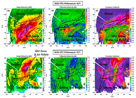
While the New Yorker implied meteorologists disdain for the term, wintry mix actually is looking more beautiful than ever to scientists–so nice we put the words on the cover of the latest BAMS: “Snow Globe: Dual Pol Deciphers Wintry Mix.”
This cover article in BAMS, by Picca et al., looks at New England’s monster blizzard of 9 February 2013, which unloaded more than 3 feet of snow on much of central Connecticut and Long Island. Dual pol radar’s unique modes deciphered the wintry mix inside an intense snowband producing lightning and snowfall rates of 3-6 inches per hour.
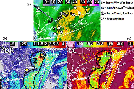
A similar article in Weather and Forecasting, by Griffin et al., documents for the first time polarimetric radar signatures of the same intense convective band of snow. The transition zone from freezing to non-freezing air (0°C isotherm) was exceptionally distinct in the radar signatures.
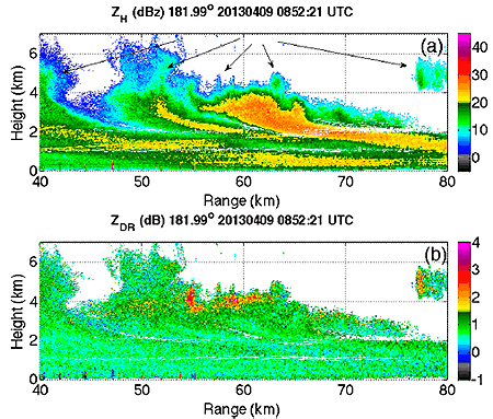
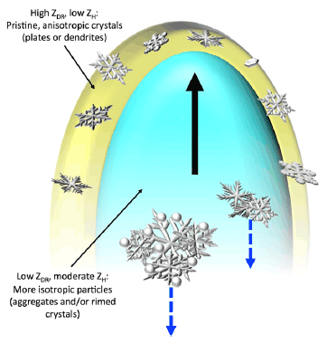
In the Journal of Applied Meteorology and Climatology (JAMC), the article by Kumjian et al. discusses the use of intensive radar measurements to study the finescale structure of more than a dozen Colorado Front Range snowstorms. And in Monthly Weather Review, Geerts et al. explain in their article how a specifically synthesized dual Doppler radar technique in an airborne platform was able to directly measure hydrometeor vertical motion, improving the accuracy of the radar.
 Chris
Chris
New Standard Aims to Improve Tornado, Severe Wind Estimates
By Jim LaDue, NWS Warning Decision Training Branch
For more than four decades, the go-to for rating tornadoes has been the Fujita Scale, and in the last eight years, the Enhanced Fujita Scale, or EF Scale. Soon, scientists and NWS field teams will have a new and powerful benchmark by which to gauge the extreme winds in tornadoes and other severe wind events.
The American Society of Civil Engineers (ASCE) has approved the EF Scale Stakeholder Group’s proposal to develop a new standard for estimating wind speeds in tornadoes. This standard will allow, for the first time, a rigorous process to improve not only the EF-scale but to adopt new methods to assign wind speed ratings to tornadic and other wind events.
The intent is to standardize methods. According to the ASCE blog, “The content of the standard would include improvements to the existing damage-based EF scale to address known problems and limitations.” ASCE went on to state that the data used for estimating wind speeds would be archived.
The EF Scale Stakeholders Group, composed of meteorologists, wind and structural engineers, a plant biologist, and a hydrologist, held a series of meetings over the past year to discuss methods available to provide wind speed estimations. The consensus among the group is that many methods exist in addition to that used in the EF Scale today. These include mobile Doppler radar, tree-fall pattern analysis, structural forensics, and in situ measurements. The group also discussed ways that the EF Scale could be improved through the correction of current damage indicators and by adding new ones. The outcome of these discussions is available online.
The new standard will be housed under the Structural Engineering Institute (SEI) of the ASCE. Users of the standard include but are not limited to wind, structural, and forensic engineers, meteorologists, climatologists, forest biologists, risk analysts, emergency managers, building and infrastructure designers, and the media.
Interested parties are encouraged to apply to the committee, selecting Membership Category as either a General member with full voting privileges or as an Associate member with optional voting capabilities. Membership in ASCE is not required to serve on an ASCE Standards Committee.
The online application form to join the committee is available at http://www.asce.org/codes-standards/applicationform/.
The new committee will be chaired by Jim LaDue and cochaired by Marc Levitan of the National Institute of Standards and Technology. For more information or questions about joining the committee, please contact us at james . g . ladue @ noaa . gov and marc . levitan @ nist . gov.
Time to Heed the Hurricane Season Forecast?
With this year’s Atlantic hurricane season getting underway, seasonal forecasts are collectively calling for a quieter-than-usual year in the Atlantic basin, which includes the Caribbean Sea and Gulf of Mexico. With busts in these forecasts as recent as last year, however, is this actually reassuring news?
Mark Powell, a NOAA hurricane researcher who is now working with Florida State University’s Center for Ocean-Atmospheric Prediction Studies, was quoted in a recent Palm Beach Daily News article saying such forecasts, which typically are made before the start of the six-month season, “just don’t have any skill this early.”
They practically don’t. The major players of Atlantic hurricane season forecasts—NOAA, Colorado State University (CSU), and the private British forecasting firm Tropical Storm Risk (TSR)—stipulate that there is only a small increase in skill with pre-season forecasts (i.e., how much better such forecasts are) compared to climatology in foretelling the number of named storms that will form in the Atlantic basin from June 1 to November 30. Supporting this, a talk by Eric Blake of the National Hurricane Center presented at the 29th AMS Conference on Hurricanes and Tropical Meteorology stated that NOAA’s May forecasts for anticipated numbers of storms and hurricanes are only slightly better than what climatology showed had occurred in the previous five seasons. Forecast skill does increase as the season nears its peak months: August, September, and October, which is when 70 percent of tropical storms and hurricanes form.
But even these “better” mid-season forecasts can be wrong. In 2013, early predictions for an active season remained high as September neared, yet the actual number of named storms (13) and especially hurricanes (just 2) fell short of most forecasts, which had been collectively predicting a blockbuster season with at least seven hurricanes and three major hurricanes. The long-term average number of named storms and hurricanes is 12 and 6, respectively. There wasn’t a single major hurricane sporting winds greater than 110 mph last year, when climatology said there should have been at least three. In a blog post at the end of last year’s season, Jeff Masters of WeatherUnderground.com detailed the reason the forecasts failed: the large-scale atmospheric circulation, which can’t be predicted more than a week or two out and isn’t part of seasonal forecasts, was not conducive to tropical cyclone formation.
In 2012, however, it was, and the opposite occurred. The number of named storms peaked at 19—not only well above average but also the third highest number of storms on record in a single season. Ten of these went on to become hurricanes, exceeding most seasonal forecasts including NOAA’s, which had called for an average Atlantic hurricane season prior to its start. CSU had projected in June of that year a relatively quiet hurricane season with 13 named storms and only 5 hurricanes. With twice that many hurricanes forming, the season blew the forecast out of the water, making it CSU’s worst bust in decades of predictions. Until 2013.
This year, however, hurricane season forecasters feel the chance of the development of El Niño by the fall is much higher than it was in 2012—70 percent this summer increasing to 80 percent by fall, according to NOAA’s 9 June El Niño status statement—which lends significant weight to the lower hurricane predictions.
Historically, El Niño stifles Atlantic hurricanes. The enormous slug of warmer-than-normal sea surface temperatures along the Eastern Pacific equator, which defines El Niño, imparts a shift in the atmosphere’s circulation that drives unusually strong winds at high altitudes across the tropical Atlantic Ocean during the season. The induced wind shear—a difference in both speed and direction between the surface and aloft—suppresses not only tropical cyclone development but also formation, tearing apart hurricane seedlings before they can organize.
Research in recent years (Journal of Climate: 2009, 2013), however, has shown that a very different effect can result from El Niño’s half-brother – an anomalous warming in the tropical Pacific that pools in the central rather than the eastern part of the ocean basin. When this occurs, as it did in 2004, it can actually amplify the Atlantic hurricane season. That year, four hurricanes—three of them major, including Charley with 150 mph winds—slammed Florida. There were 15 named storms that year.
No forecasters expect a repeat of the devastating 2004 hurricane season. But, already we’ve had a record eight hurricane seasons without landfall of a major hurricane in the United States nor any category hurricane striking Florida. The last one was Wilma in 2005, which hit as a major hurricane.
Whether or not forecasts are accurate this early in the season, the old adage still applies: it only takes one hurricane in your area to create disaster. So be prepared.
Your Chance to Honor Your Colleagues…by Thursday
Time is running out to submit nominations for more than two dozen AMS awards in the atmospheric and related sciences. The deadline for submission is Thursday, 1 May.
Each year the American Meteorological Society seeks the nomination of individuals, teams of people, and institutions for their outstanding contributions to the atmospheric and related sciences, and to the application of those sciences. That means recognition of achievements not only in meteorology but also oceanography, hydrology, climatology, atmospheric chemistry, space weather, environmental remote sensing (including the engineering and management of systems for observations), the social sciences, and other disciplines.
Twenty-five AMS awards, such as the Carl Gustaf-Rossby Research Medal—meteorology’s highest honor—and the Jule G. Charney and Verner E. Suomi medallions, are available to scientists, practitioners, broadcasters, and others. And every year, you, as AMS members, make the nominations and ultimately determine whose amazing achievements to honor with these prestigious awards.
Descriptions of the AMS awards, including links to the nomination procedure, are available on the AMS website. All nominations must be submitted online.
Sharing the May 1 deadline are nominations for AMS Fellows and Honorary Members. The advancement to Fellow is one of the most significant ways the Society honors those AMS members who, over a number of years, have made outstanding contributions in academia, government, industry, and more.
Submitting a nomination takes little of your time but potentially rewards a colleague enormously.
For those nominations we have received and those to be submitted by Thursday, the AMS thanks you.
Awardees and Fellows will be recognized at the 2015 AMS Annual Meeting.
AMS Presidential Town Hall Meeting to Stress Adaptation, Resilience to Climate Change
In weather forecasting, the past is often a harbinger of the future. In a rapidly urbanizing world facing climate change, however, the future looks less and less like the past. With a theme of Building, Sustaining, and Improving our Weather and Climate Hazard Resilience, we’re facing this problem head on at the AMS Annual Meeting, nowhere more so than in tonight’s Presidential Town Hall Meeting (7:00–8:30 p.m., Room C111 of the Georgia World Congress Center).
The speakers include FEMA Administrator Craig Fugate and an IPCC coordinating lead author, Donald Wuebbles—two key figures in communicating climate change hazards and adaptation. Helping all to visualize extremes in the weather will be NCAR’s Mel Shapiro—a master at telling a tale through stunning imagery. This time his tale is Superstorm Sandy, which crashed ashore in the Northeast in fall 2012 with deadly fury. Sandy exposed just how vulnerable our nation is to natural disasters. Storm surge flooding didn’t just wreck the beaches, our playgrounds at the shore. Seawater rushed inland, flooding airports and mass transportation routes and partially disconnecting the biggest city in America—and financial heart of the nation—from its neighbors. The price tag was enormous.
You’ll hear a lot at the Town Hall about how weather- and climate-driven disasters in America are costing us more and more. Multibillion-dollar weather disasters, once consisting solely of major hurricanes and extended drought, are becoming common—even from small-scale thunderstorms. With a climate that’s heating up–resulting in an increase in extreme weather, as Wuebbles will discuss–so too will we see an increase is such megadisasters.
Wuebbles’ playbook on Monday will be the fifth assessment report (AR5) of climate change by the Intergovernmental Panel on Climate Change (IPCC). Wuebbles was coordinating lead author of the Working Group 1 section, which was released in full form last week. He says he plans to overview its findings with “an emphasis on our state of understanding of severe weather events under a changing climate.” The presentation will include a preview of the U.S. National Climate Assessment to be released in April.
Wuebbles, who is an atmospheric science professor at the University of Illinois, will also report from a series of NOAA workshops evaluating attribution science (in BAMS here, here, and here), which currently supports making useful projections on some but not all types of severe-weather events. Projections of heat waves and cold spells as well as heavy precipitation events are now possible, and “meaningful trends in floods and droughts” are also discernible by region in the United States. Confidence in an increase in hurricane intensity as the climate warms is also growing. But forecasts of how climate change will affect severe thunderstorms and tornadoes, which in recent years have broken into the billion-dollar disaster range, remain out of reach for now, Wuebbles says, but he adds, “By the next assessment we may be able to make stronger statements.”
Even without the financial burden, today’s weather disasters are becoming debilitating. Look no further than last week’s shutdown of Atlanta due to a well-forecast snowfall. It shouldn’t have happened—particularly since the city went through the same thing just three years ago (January 2011), only with a slightly heavier snowfall. No one thought it could happen again, but it did.
Our ability to successfully communicate is challenged most when disaster strikes. That’s where Fugate comes in. As the top emergency manager in the nation, his job is to organize meaningful and rapid response, which relies on successful communication.
The key is to organize lines of communication beforehand, so when the weather becomes extreme, the avenues of information will remain open. But there are other forms of disaster response. Fugate sees resilience to disaster through increasing adaptation as the way forward in a changing climate. By reducing the risk, he believes we can manage to recover more quickly from extreme weather events. Most importantly, in his view, is to turn victims of disaster into what he prefers them to be called: survivors. He encourages neighbors and communities to get better at coming together when disaster occurs and to help each other overcome the odds and survive.
As AMS Associate Executive Director Bill Hooke explains in Sunday’s Living on the Real World column, there are many levels of disaster response, and all of them “need to be mastered.” When disaster strikes a community, its residents probably will look to the top command-and-control such as FEMA to make things right. But at the other end of disaster response is personal responsibility. Each of us has the task before us to take action to improve our situation. We can wait for disaster to strike, but better would be to plan now how to adapt and make ourselves resilient to weather and climate hazards so they won’t turn into catastrophes.
Reassessing the Enhanced Fujita Tornado Scale
It’s been more than 40 years since Ted Fujita introduced his renowned Tornado Damage Scale – the Fujita Scale. And nearly a decade has passed since top tornado scientists first collaborated with structural engineers to create the Enhanced Fujita (EF) Scale for rating tornado winds more accurately based on advances in our understanding of the variety of damage they inflict. Now, an effort is underway to tweak the EF Scale further – and the National Weather Service is looking for input from AMS meeting attendees this week.
The effort stems from the observations and analysis of recent violent tornado events: the massive tornado outbreak across the South in April 2011; the violent (EF5) Joplin, Missouri tornado of May 2011; and the Newcastle-Moore, Oklahoma EF5 tornado of May 2013. Survey teams were able to use more than two dozen “damage indicators,” such as wood-frame homes, strip malls, and schools—each further categorized by multiple “degrees of damage”—to gauge tornadic winds. But questions and even discrepancies arose among the survey teams as they scoured the wreckage of entire neighborhoods.
Oral and poster presentations throughout this week at the AMS Annual Meeting in Atlanta share information about the damage surveys, findings from reports such as the National Institute of Standards and Technology (NIST) technical investigation of the Joplin tornado and FEMA’s Mitigation Assessment Team Report on the Spring 2011 tornadoes, as well as thoughts for improving the EF-scale:
- The Joplin Tornado: Lessons Learned from the NIST Investigation (Tuesday, 9:15 a.m., Georgia Ballroom 2)
- Damage Survey and Analysis of the 20 May 2013 Newcastle-Moore, OK, EF-5 Tornado (Poster 828, Wednesday, 2:30-4 p.m., Hall C3)
- Aerial Damage Survey Analysis of the 20 May 2013 Moore Tornado (Poster 829, Wednesday, 2:30-4 p.m., Hall C3)
- Side-by-side tree and house damage in the May 2013 Moore, OK EF-5 tornado: Lessons for the Enhanced Fujita scale (Poster 831, Wednesday, 2:30-4 p.m., Hall C3)
- A related poster presentation looks at assigning EF-scale ratings to tree damage in severely damaged forests using only aerial photos.
- Photogrammetric analysis, from the ground and the air, was also used to survey the huge El Reno, Oklahoma of May 31, 2013,
- Terminal Doppler Weather Radar (TDWR) in Oklahoma City captured rare up-close velocity data of the Newcastle-Moore tornado that can be compared with survey estimates of tornado damage and intensity rankings.
All of these represent on-going thinking about the EF Scale and how to refine it.
If you’d like to get involved, NWS is hosting an open discussion of the EF Scale to acquire feedback on its strengths and deficiencies. Space is limited so sign up today.
Twister that Killed 4 Storm Chasers Widest Ever
The tornado that killed 18 people in and around El Reno, Oklahoma on Friday, including three professional tornado researchers and an amateur storm chaser, was a record 2.6 miles wide, according to the National Weather Service (NWS).
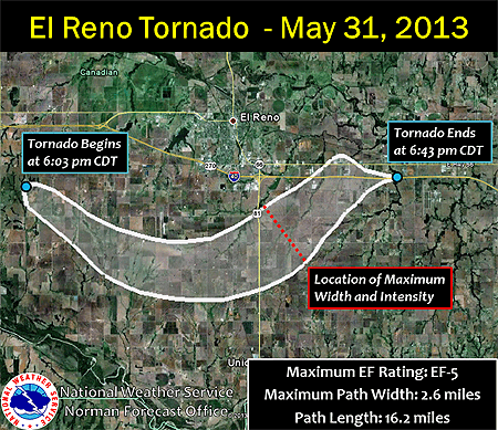
(Source: NWS Forecast Office, Norman, Oklahoma)
The NWS in Norman, Oklahoma posted the image above to its Facebook page Tuesday. In addition to being the widest tornado in U.S. history, the El Reno tornado was also rated an EF-5 with winds “well over 200 mph,” the Norman NWS stated on Facebook.
According to a blog post by Jason Samenow of the Washington Post’s Capital Weather Gang, the previous record width of a tornado was 2.5 miles, belonging to the Wilber-Hallam, Nebraska twister of May 22, 2004. It was rated EF-4 in Hallam, south of Lincoln, and damaged or destroyed about 95 percent of the village of 200 people, killing one person and injuring 37.
Friday’s tornado in El Reno, a small city just west of Oklahoma City, was upgraded to an EF-5 on the 0-5 Enhanced Fujita Scale not because of its size but because of radar-measured winds in its enormous vortex of nearly 300 mph.
According to Samenow’s post, radar teams headed by renowned tornado researchers Howard Bluestein of the University of Oklahoma and Josh Wurman of the Center for Severe Weather Research were near the El Reno tornado gathering data. Bluestein said two of his graduate students measured winds of 296 mph in the tornado’s funnel, while Wurman’s team observed winds of 246-258 mph. Both teams were scanning the tornado with mobile Doppler radars, but from different locations.
The violent and deadly El Reno tornado occurred less than two weeks and a mere 20 miles from the EF-5 tornado that devastated Moore, Oklahoma on May 20. Two dozen people lost their lives in that tornado. It brought hard luck and hard lessons back to Moore, crossing the path of the infamous EF-5 tornado of May 3, 1999. Wurman’s Doppler on Wheels radar clocked winds in the 1999 Moore tornado at over 300 mph.
Over the weekend, numerous media outlets (KFOR-TV, CNN, The Weather Channel), cable TV channel websites (NatGeo, The Discovery Channel), and blog posts (Capital Weather Gang, Weatherunderground) covered the shocking news of the first-ever deaths of storm chasers by a tornado. Tim Samaras, a professional storm chaser and tornado researcher for nearly 30 years and an Associate Member of the AMS, along with his photographer son Paul and researcher Carl Young were killed when their chase vehicle was violently thrown and mangled by the El Reno tornado. The Daily Oklahoman reported Tuesday that amateur storm chaser Richard Charles Henderson was killed the same way. His pickup truck was overrun by the tornado winds moments after he sent a friend a cellphone photo of the El Reno tornado.
A New Metric for Hurricane Destruction Potential
Hurricanes Katrina (2005), Ike (2008), and Sandy (2012) have proven the Saffir-Simpson Scale is inadequate for expressing hurricane destructiveness. This is especially true for storm surge, which the original Category 1-5 wind damage potential rating scale wasn’t designed to classify.
As another Atlantic hurricane season begins, a study now accepted for publication in Monthly Weather Review introduces a new metric for measuring the destructive potential of tropical cyclones: Track Integrated Kinetic Energy. TIKE builds on the earlier concept of Integrated Kinetic Energy to represent destructive potential by computing a storm’s sustained wind field quadrant-by-quadrant along its entire track. Summing up the IKE values over the tropical cyclone’s lifecycle more accurately determines the potential for destruction, the study concludes.
Additionally, TIKE can be accumulated for all of a tropical cyclone basin’s storms in a given year to create “an important metric of that season,” the authors write in a summary of their research (to appear in an upcoming issue of the Bulletin of the AMS).
Vasu Misra, lead author of the study “The Track Integrated Kinetic Energy of the Atlantic Tropical Cyclones,” adds:
Existing metrics such as Accumulated Cyclone Energy (ACE) or the Power Dissipation Index (PDI) only consider the peak wind in the storm, which is difficult to measure and typically only covers a very small area and contributes little to storm surge and wave damage. TIKE takes into account the wind forcing over a large area surrounding the storm and is therefore much more reliable as an objective measure of hurricane destructive potential. In effect TIKE accounts for the intensity, duration, size, and structure of the tropical cyclones.
The study by Misra and his colleagues also looks at seasonal and season-to-season as well geographic variations of TIKE. Among its findings:
- TIKE peaks in September along with hurricane season overall, since that’s when the Atlantic Ocean is warm enough to fuel large and long-lived storms;
- Very active hurricane seasons such as 2005 may not be the most destructive since some large and powerful hurricanes may be short-lived;
- Annual variations in TIKE are related to sea surface temperature variations in both the equatorial Pacific (warmer temperatures there relate to lower TIKE in the Atlantic) and the Atlantic (its warmer temperatures relate to higher TIKE there).
The MWR article abstract is open to all readers, while subscribers can read the full Early Online Release on the AMS journals website.
Hurricane Center Changes Policy to Include Sandy-like Storms; AMS Forum Assists
If another storm like Sandy threatens land while on the cusp between tropical and extratropical classification, National Hurricane Center (NHC) forecasters will have a green light to issue or maintain watches and warnings as well as advisories, even after transition.
That’s the policy change NWS/NHC made this week after months of animated debate among forecasters, weather broadcasters, and emergency managers. The changes will take effect at the start of the 2013 Atlantic hurricane season, June 1.
The shift—from watches, warnings, and advisories only being posted by NHC when a storm was expected to be strictly tropical as it came ashore to now being allowed for what it terms “post-tropical” storms at landfall—was borne of a critical firestorm.
Despite the enormous threat from Sandy last October, NWS and NHC decided not to hoist hurricane watches and warnings for the northeastern coast of the United States because the monster storm wasn’t forecast to land its center on shore while still a hurricane. The re-classification of Sandy as post-tropical would have forced such alerts to be dropped mid storm, which they argued would cause confusion.
Critics of the decision claimed that people in harm’s way didn’t take the storm seriously because there weren’t any hurricane warnings in place. Nearly 70 people died in the United States directly from Sandy’s surge and wind.
The fallout included broad discussions of the difficulty forecasting Sandy. At an AMS Town Hall Meeting in Austin, Texas, in January, Louis Uccellini (then director of NOAA’s National Center for Environmental Prediction) said that NWS and NHC forecasters had anticipated Sandy transitioning from a hurricane to an extratropical storm, but they expected it to happen sooner than it actually did. In his presentation, he also noted that the primary operational forecast model used by the NWS (the Global Forecast System, or GFS, model) had performed the best of all models during the 2012 Atlantic hurricane season, but when it counted—with the season’s only two landfalling U.S. storms of hurricane intensity (Isaac and Sandy)—it had the worst forecasts.
“When you don’t hit the big one, people notice,” he said.
Compounding the uncertain model forecasts was what to do with the warnings if the transition occurred prior to landfall. NHC Director Rick Knabb discussed this at the same AMS Town Hall meeting, calling it the “Sandy warning dilemma.” He agreed that hurricane warnings would have been best, because they’re familiar and grab your attention. But, because of the looming transition, discussions among NHC and NWS forecasters as well as emergency managers and local and state authorities, including one governor, stressed that the warning type not change during the storm for fear of confusing the message during critical times of preparation and evacuation. Due to the structure for hurricane warnings in place at the time, which would have forced NHC to drop them once the transition occurred, NHC and NWS forecasters opted not to issue a hurricane warning for Sandy.
“We wanted to make sure the warning didn’t change midstream, and we could focus on the hazards.”
Ultimately, calls settled on a way to effectively communicate the threat of dangerous winds and high water regardless of a storm’s meteorological definition. A proposal surfaced during the Town Hall that would broaden the definition of tropical storm and hurricane watches and warnings and include post-tropical cyclones, whose impacts still pose a serious threat to life and property.
Knabb credits the candid nature of the months-long debate, with its criticisms and recommendations, for the now-approved proposal. He says it will allow NHC and NWS forecasters as well as the emergency management community to focus on what they do best.
“Keeping communities safe when a storm threatens is truly a team effort and this change reflects that collaboration.”
Hurricane Sandy: NHC Final Report and AMS Town Hall Presentations Online
The National Hurricane Center released its post-storm report on Hurricane Sandy this week, confirming the many nuances of the late-season monster storm we already knew. Yet it’s the details, provided by scientists attuned to getting the minutiae right, that make the report an inviting read.
For starters, the NHC report confirms that Sandy wasn’t a hurricane at landfall. Its core convection collapsed as the center of the storm moved west of the warm waters of the Gulf Stream—the same warm waters that earlier on the day of landfall (October 29, 2012) cranked up Sandy’s winds to 100 mph as the center closed in on New Jersey. Cold air wrapping into Sandy’s center contributed to the collapsing convection, and this structural change transitioned Sandy from tropical to extratropical just 50 miles offshore of Atlantic City.
Post analysis of the storm’s intensity in the Caribbean also explains why NHC has now upgraded Sandy to a Category 3 “major” hurricane with 115 mph winds from Category 2, which at the time had been considered the peak classification prior to landfall in southeastern Cuba. The destruction wrought there, described as “especially severe,” included more than a quarter-million homes damaged and 17,000 sheared to pieces by the extreme winds. Gusts topped 110 mph before disabling the anemometer in Santiago de Cuba, the island nation’s second-largest city, and reached an incredible 165 mph at Gran Piedra (“Big Rock,” elev. 2,000 feet) in the national park east of the city. Sandy killed 11 people in Cuba, an unusually high number in a nation that has weathered numerous ferocious hurricanes with lesser loss of life. It was a testament to Sandy’s fury.
Additionally, the report describes changes proposed to NHC’s watch/warning criteria. If adopted, they will address limitations to the use of tropical storm and hurricane watches and warnings when tropical cycl0nes transition to extratropical (i.e., non-tropical or “post tropical”) storms. Facing the potential for Hurricane Sandy to make such a transition prior to striking the Northeast, NHC opted not to issue hurricane watches and warnings north of North Carolina because the transition would force NHC to discontinue them even though the threat for severe wind and tidal conditions remained, which “would cause an unacceptable level of confusion and disruption during critical periods of preparation that included evacuations.” The decision was widely criticized and cited as contributing to the large number of deaths due to storm surge flooding and falling trees in and around New York City.
The report has much more, including details about the record storm tides in New York City, New Jersey, and Connecticut, flooding rain in the mid-Atlantic states, and snow in the Appalachians, as well as a breakdown of U.S. deaths and an abundance of observations.
Town Hall Meeting on Sandy
Recordings of the the presentations made at the AMS Town Hall Meeting on Hurricane Sandy at the Annual Meeting in Austin are now available.
Hurricane Sandy Introduction
Tanja Fransen, NOAA/NWS, Glasgow, Montana
Introduction to Sandy and the Major Impacts
Louis W. Uccellini, NOAA/NWS/NCEP, Camp Springs, Maryland
Hurricane Sandy: Hurricane Wind and Storms Surge Impacts
Richard D. Knabb, NOAA/NWS/NHC, Miami, Florida
Post-Tropical Cyclone Sandy: Rain, Snow and Inland Wind Impacts
David Novak, NOAA/NWS/Hydrometeorological Prediction Center, College Park, Maryland
A Research-Community Perspective of the Life Cycle of Hurricane Sandy
Melvyn A. Shapiro, NCAR, Boulder, Colorado
Communicating the Threat to the Public through Broadcast Media
Bryan Norcross, The Weather Channel, Atlanta, Georgia
Following the Storm through Social Media
Jason Samenow, Washington Post, Washington, D.C.; and Andrew Freedman, Climate Central, New York, N.Y.
Storm Response in New York and New Jersey
Eric Holthaus, The Wall Street Journal, New York, N.Y.