Did You Hear? Echoes from the Annual Meeting

This year’s AMS Annual Meeting provided no shortage of memorable presentations. The focus on 2017’s hurricanes in particular yielded some of the most memorable moments, and now you can listen (again, or for the first time) for yourself. Recorded presentations are being uploaded gradually to the AMS meeting program site.
Richard Alley’s speech at the Presidential Forum was the first to go online, here including AMS President Roger Wakimoto’s introduction as well as questions from the audience:

Here’s a portion of Dr. Alley’s memorable riff on our semi-aware relationship to the science and technology we carry around in our pockets every day:

I’m a Newtonian physicist. I didn’t take quantum, I didn’t take relativity. But my understand is that the nice lady in the (cell) phone using the GPS is using both general and special relativity. Because down here, she is deeper in Earth’s gravity well and she is moving slower than the clocks on the satellite. And the correction from relativity is about 10 km a day. And she can do 10 km pretty easily. Which means if she didn’t have relativity, she would get lost in about two minutes. And that’s … We get where we’re going not only because of quantum mechanics but also because of Einstein. And, no, she will not fall for you because she’s canoodling with Einstein in the phone here.
But you know how these things work. Right? … I’ve been working on ice since 1977, the summer after my freshman year. My teachers, in geology and other things, I think if you were to ask them what is the most useless and esoteric science you can think of, they might have said relativity and quantum mechanics. And you’ve got relativity and quantum mechanics in your phone, in your pocket, and you can’t really think of living the life you now live if we didn’t understand relativity and quantum mechanics….
Climate science is not this new-fangled stuff you’ve got in your cell phone … it’s been with us for a long time. But I can tell you, and some of you out there know this as well, that there are people—good people, neighbors, people who pay our salaries—who will pull out their cell phone and send me a note saying, ‘You’re an evil liar. You should be fired.’ They go to my president and try to get me fired. Because I’m talking about this global nonsense. ‘These scientists are just trying to take away our pickup trucks.’ And they do it with a cell phone. And they are, I think, all across the board, good people. Some of them have been misled. And that’s something we have to come back to.

Also online now are the talks from the web-streamed Presidential Town Hall on the hurricane season.  Well worth a listen while you’re waiting for more talks to appear online, like this reaction to forecasting Hurricane Irma, from NBC-6 Miami Chief Meteorologist John Toohey-Morales:

In South Florida I’m known as the non-alarmist guy. I mean if you want a just-the-facts-and-he’s-not-at-all-that-excited-about-this-tropical-cyclone guy, I’m your person … But with Hurricane Irma … on Friday night … National Weather Service Key West … about to go into full-Katrina mode: catastrophic, life threatening, and those types of messages were about to go out … what does the non-alarmist guy do? (Plays video of his TV broadcast that Friday night.) ‘If you’re sitting on a Florida Key right now—What the heck are ya doing? Get out! Now!’

Or this zinger from FEMA’s Tony Robinson, while talking about Hurricane Harvey:

Working with our counterparts in the state of Louisiana a guy said, ‘I finally figured out your flood codes on when I should have flood insurance.’ And I said, ‘Oh, yeah? What’s that?’ He said, ‘Your driver’s license says Louisiana, you aughta have flood insurance.’ That’s a public service announcement right there. There’s 144 days to the start of the 2018 hurricane season.”

But it was Ada Monzon, WIPR TV/WKAQ Radio, San Juan, who drew a rare standing ovation after her heartfelt presentation on Hurricane Maria:

And I can tell you, that in my 30 years as a meteorologist in Puerto Rico, even going through Hugo and Georges and more than 10 other tropical storms … (I’m sorry) … For the first time in my life I was afraid. Not because of the wind or the storm surge or the rain. I was afraid [for] the future of Puerto Rico. … Still to this day there are great discrepancies on how many people died in Puerto Rico because of Maria. By government information, there were 64 dead. Our other entities have informed … of more than 1,000 dead. … The response and recovery efforts have been very slow and complicated. More than three months after the hurricane, near 45% of the island is still without power. Many are suffering. More than 100,000 people have left the island in the last three months, to Florida, New York, Texas. … Enduring two major hurricanes has been hard. But at the same time it has served a vast lesson to all our society: We need to find a way of living with natural disasters and other potential catastrophic events and we need to work harder as meteorologists and scientists to educate our public through all means of communication, especially social media.

 

Time Machines, Horse Ploppies…Richard Alley Will Do the Talking Today

From his book and PBS-TV series, “Earth: The Operator’s Manual,” to his renowned lectures at Penn State, Dr. Richard Alley is known for his humorous descriptions about serious science. Today he is the featured speaker as the 98th Annual AMS Annual Meeting begins in Austin, Texas.  Richard Alley
At the 18th AMS Presidential Forum  (4 pm, Ballroom D) Dr. Alley will use his unique brand of communication to discuss why communicating science to the public is no longer optional, but rather an imperative.
Dr. Alley, a renowned glaciologist and climate scientist, has a way with words. His colorful metaphors–like The Two-Mile Time Machine, the title his award-winning popular book about ice cores–put complex scientific issues into a comfortable perspective for perplexed audiences.
Last May, a couple months before a large piece of Antarctica’s Larson C ice shelf broke off,  Rolling Stone published an article about  potential catastrophic collapse of West Antarctica ice. In it, Dr. Alley explained that the Larson C breakage would not necessarily be an “end-of-the-world screaming hairy disaster conniption fit.”
And here, transcribed from a 2012 talk at the Smithsonian in which Dr. Alley explained the impact of burning fossil fuels and releasing CO2:

“You fill up a car and it’s a fairly big tank–you’re putting in a hundred pounds of gasoline. If you had to bring it home in gallon jugs it’d be a different world. But you drive off with it. And when you burn it — you add oxygen — and that makes CO2, and it goes out the tailpipe and you don’t see that 300 pounds per fill-up. Now, our students really get a kick out of it: at this point you say okay, suppose that our transportation system packaged the CO2 in a way we could see it … as horse ploppies…It’s a pound per mile driven for a typical vehicle in the fleet at this point. Ya know … Nnnnn — thffft. Nnnnn — thffft …. Our CO2 turned to the density of horse ploppies and spread over the roads of America would cover every road in America an inch deep every year. On average. Okay. In a decade … there are no joggers. We’d all be cross-country skiers. If we saw this it would be a completely different world. But it just drifts away and we don’t even see it.”

Sunday’s keynote talk at the Presidential Forum is likely to be just as, ummm, vivid. Simple but powerful. Definitely memorable.
It’s exactly the way Alley envisions engaging the public: by building the broad understanding necessary to make science actionable.

The Trouble with Harvey: Hurricane Intensification Dilemmas

Hurricanes like rapidly-changing Harvey are still full of surprises for forecasters.
The remnants of Caribbean Tropical Storm Harvey made a startling burst Thursday from a tropical depression with 35 mph winds to an 85 mph hurricane in a little more than 12 hours. It has been moving steadily toward a collision with the middle Texas coast and landfall is later Friday. If intensification continues at the same rate, Harvey is likely to be a major hurricane by then, according to a Thursday afternoon advisory from the National Hurricane Center, with sustained winds of 120-125 mph and even higher gusts.
That’s a big “if.”
The drop in central pressure, which had been precipitous all day—a sign of rapid strengthening—had largely slowed by Thursday afternoon. Harvey’s wind speed jumped 50 mph in fits during the same time, but leveled off by late afternoon at about 85 mph. Harvey was a strong Category 1 hurricane on the Saffir-Simpson Hurricane Wind Scale by dinner time.
The intensifying process then slowed. But it turns out this was temporary.
Many signs pointed to continued rapid intensification: a favorable, low-shear environment; expanding upper-air outflow; and warm sea surface temperatures. Overnight and Friday morning, Harvey continued to traverse an eddy of water with high oceanic heat content that has detached from the warm Gulf of Mexico loop current and drifted westward toward the Texas coast. Its impact is apparent as the pressure resumed its plunge and winds have responded, blowing Friday morning at a steady 110 mph with higher gusts.
Further intensification is possible.
In fact, the SHIPS (Statistical Hurricane Intensity Prediction Scheme) Rapid Intensification indices “are incredibly high,” Hurricane Specialist Robbie Berg wrote in the Thursday morning forecast discussion. Guidance from the model then showed a 70 percent chance of another 50 mph jump in wind speed prior to landfall. The afternoon guidance lowered those odds a bit, but still showed a a 64 percent probability.of a 35 mph increase.
It wouldn’t the first time a hurricane has intensified rapidly so close to the Texas coast. In 1999 Hurricane Bret did it, ramping up to Category 4 intensity with 140 mph winds before crashing into sparsely populated Kennedy County and the extreme northern part of Padre Island.
Hurricane Alicia exploded into a major hurricane just prior to lashing Houston in 1983. And 2007’s Hurricane Humberto crashed ashore losing its warm water energy source and capping its intensity at 90 mph just 19 hours after being designated a tropical depression that morning off the northern Texas Coast, a similar boost in intensity as Hurricane Harvey.
Rapid intensification so close to landfall is a hurricane forecasting nightmare. An abundance of peer-reviewed papers reveal that there’s a lot more we need to learn about tropical cyclone intensity, with more than 20 papers published in AMS journals this year alone. Ongoing research into rapidly intensifying storms like Harvey, is helping solve the scientific puzzle, including recent cases such as Typhoon Megi  and Hurricane Patricia. Nonetheless, despite strides in predicting storm motion in past decades, intensification forecasting remains largely an educated guessing game.

Atlantic Hurricane Season Begins

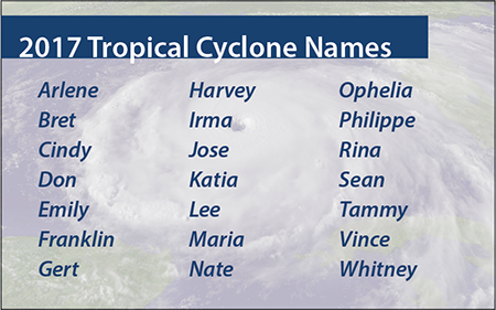
2017 Atlantic hurricane season namesThe 2017 Atlantic hurricane season has begun. If they haven’t already, people who could be affected by tropical storms and hurricanes should prepare now for the six-month season, which ends November 30 and encompasses the Atlantic Ocean, Caribbean Sea, and Gulf of Mexico.
Here’s what you need to know. Follow the links for more detailed information:
What’s New
Two new products this year will be issued by the National Hurricane Center in addition to the typical tropical storm and hurricane watches, warnings, and advisories:

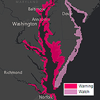
  • Storm surge watches & warningsStorm surge watches will be issued within 48 hours of possible life-threatening coastal inundation. Storm surge warnings will be issued at least 36 hours before the danger of life-threatening coastal inundation is realized. The new graphical products will be issued in tandem with NHC’s Potential Storm Surge Flooding Map, which quantifies the expected inundation from storm surge and indicates the depth of the flooding on land.
  • Potential tropical storms and hurricanes growing out of disturbances that have not yet become tropical depressions or storms but that pose the threat of bringing tropical storm or hurricane conditions to land areas in 48 hours will be treated as regular storms, with NHC issuing watches, warnings, advisories, and related graphical products as needed.
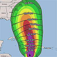
  • Arrival of tropical storm windsAdditionally, NHC will introduce a map to provide guidance on when users should have their preparations completed before a storm. These experimental graphics will show Time of Arrival of Tropical-Storm-Force Winds—a critical planning threshold for coastal communities. Many preparations become difficult or dangerous once tropical storm conditions begin.

Prepare
People living in states bordering the Atlantic Ocean and Gulf of Mexico, as well as in The Bahamas, Bermuda, and Caribbean islands, should know that water could be a life-threatening hazard when a hurricane hits. This threat includes storm surge—the sudden rise of seawater at the coast near and to the right of where a hurricane’s center makes landfall. In the United States, hurricane evacuation maps account for the flooding from storm surge and show areas along the coast that people should evacuate if a hurricane threatens. Or it could be from freshwater flooding triggered by a storm’s torrential rain. If either is a risk, make a plan now to leave when threatened.
If water is not a risk, and your area will only face the threat of strong, damaging winds, the official recommendation from the National Hurricane Center is to shelter in place. Meaning, stay put—rather than evacuate. But stay only if your residence is sufficient to weather the storm. Now is the time to prepare your home and property for the possibility of high winds and heavy rain.
Forecasts
A wide variety of academics, private forecasting companies, and the U.S. government issue seasonal hurricane predictions. They generally tend to agree, particularly when a season is expected to be well above or below average. But this year could be a bit different with some predicting fewer tropical storms and hurricanes than is typical in an average year, and others predicting more than the usual numbers of storms and hurricanes. An average Atlantic hurricane season sees a dozen named storms, with a half-dozen of these becoming hurricanes and two going on to become major hurricanes with sustained winds greater than 110 mph.
A quick look at the five longest-running seasonal forecasts for named storms, hurricanes, and major hurricanes, respectively:

The reason for the low numbers in those forecasts with ranges: there’s uncertainty about whether another El Niño may form midway though the season—El Niño is an anomalous warming of the eastern tropical Pacific that causes air to rise and spread out there, creating wind shear over the Atlantic that inhibits tropical development—as well as whether warmer-than-usual sea surface temperatures in the tropical Atlantic favorable for development will remain that way or cool through the season. Increasing numbers in several forecasts updated since earlier in the spring seem to indicate a lower likelihood of both, although forecasters caution they could reduce the numbers if more than a weak El Niño develops and Atlantic SSTs consequently cool.
Bottom Line
Nearly every weather entity states what Acting FEMA Administrator Robert J. Fenton, Jr. recently expressed after NOAA released its hurricane season forecast last week: “Regardless of how many storms develop this year, it only takes one to disrupt our lives.”
The advice of hurricane forecasters and emergency managers alike is to prepare early and as if this will be the year your neighborhood is hit.
Storm Names
If this year’s list of names the National Hurricane Center will use to keep track of Atlantic storms seems familiar, it’s because it is. NHC made it all the way through this list in the 2005 season. The names of five memorable and deadly hurricanes that year were retired: Dennis, Katrina, Rita, Stan, and Wilma. The updated list was used again in 2011, since NHC rotates through six sets of names, and Irene that year also was retired and replaced.

Monster Felix Slammed Hurricane Hunter Plane in 2007

A one-two punch inside intense Hurricane Felix in 2007 turned a NOAA hurricane hunter flight into a harrowing rollercoaster ride, causing the mission to be aborted. A study of the extreme event, scheduled for publication in the next issue of Monthly Weather Review, determined a small-scale vortex known as a misocyclone rotating within the Category 5 hurricane’s eyewall is likely what bucked the plane upward nearly a thousand feet before sending it plunging back to its original altitude in less than a minute. The feature is similar to what nearly crashed the same plane inside Hurricane Hugo in 1989.
According to the study, a “routine penetration” into the eye of the hurricane via the northeast eyewall on September 2, 2007 quickly became anything but. First, the horizontal wind speed at the plane’s altitude of about 10,000 feet jumped from 140 mph to nearly 200 mph. At the same time, a standard descent into the eye at a constant 700 mb pressure height quickly steepened and the plane lost more than 700 feet in altitude in 40 seconds. Then a 70 mph updraft punched the plane up 900 feet immediately followed by a 16 mph downdraft that hammered the plane downward 980 feet, in seconds. The on-board radar quit. And gravitational stresses on the aircraft exceeded safety specifications. The mission was scrubbed and the plane then settled into Felix’s calm 12-mile-wide eye at about 8900 feet, circling five times until it could find a safe pass through the southwest eyewall and out of the hurricane.
They were lucky.
The hurricane hunters have unknowingly flown into these updraft-downdraft combinations before. They seem to only encounter them in monster Category 5 hurricanes, which have sustained winds greater than 156 mph. Besides Felix, researchers have documented the extreme events in Hurricanes Patricia (2015), Isabel (2003), and Hugo (1989). The encounter in Hurricane Hugo took place with the same hurricane hunter plane (NOAA42) flying at just 1500 feet, which was typical back then. Not any more. Fists of wind smashed the aircraft downward more than a thousand feet and then back upward, knocking out three of the its four turboprop engines and crippling the plane. It barely made it out, and afterward the rules for hurricane eye penetrations were rewritten.
Back it 1989, researchers thought they had perhaps flown into a tornado in the eyewall. But in Hurricane Isabel, data revealed a vortex a bit larger but no less intense was encountered. Similar in scope but smaller in size to the rotating 5-10-mile-wide updrafts of supercell thunderstorms, which have become known as mesocyclones, the hurricane eyewall vortexes were only a fraction of that—hence the name misocyclones, or small-scale cyclones.
In Felix, a bit of serendipity: just as the plane encountered the misocyclone, researchers released a commonly used tube of instruments called a dropwindsonde into the eyewall to measure temperature, pressure, humidity, and with onboard GPS tracking, wind speed and direction. The dropwindsonde measured details of the wind within the misocyclone, including a shift in the horizontal direction and a speed that jumped to more than 230 mph at about 400 feet decreasing to just 41 mph near the water. The tremendous shear—change in the wind speed in such a short distance—is “8 orders of magnitude larger than those known to lead to […] horizontal shearing instabilities and misocyclone development,” the study noted based on prior research.
It’s only the second time details of a misocyclone have been measured, making them largely mysterious events. For example, researchers aren’t certain how common or unusual they are. “Many very intense tropical cyclones have been sampled with aircraft without encountering these extreme events,” the study states, adding, “It is unknown whether they have been missed by the relatively sparse observations available, because aircraft tend to deviate around the most intense eyewall convection, or if they are truly rare.”
Deepening the mystery is the timing of the extreme event inside Felix—it occurred as with Hugo at the end of a period of rapid intensification, which is when a hurricane’s central pressure drops precipitously ramping up its sustained winds very quickly. Winds in Hurricane Felix increased by 90 mph to 165 mph sustained that day in 2007. It has been thought that extreme features in hurricanes such as lightning, graupel, and eyewall vortices likely occur during periods of rapid intensification, as occurred with Hurricanes Isabel and Patricia. But Felix is the second intense hurricane where such an extreme event took place at the end of a rapid intensity cycle, and learning why while keeping the hurricane hunters safe will require further study.
“The frequency of these features and their ultimate importance in the structural evolution [of hurricanes] remain research questions. It is clear, though, that improved understanding of these features would enhance the safety of flights into very intense tropical cyclones.”

Great bursting balloons, Batman!

Ever wonder what happens to weather balloons as they reach their peak altitude and can’t take the low pressure anymore? They pop, right? Nope. They shatter! Shred! Explode!
This video shows the unique way a weather balloon bursts at about 30,000 m.

Credit: Patrick Cullis (NOAA/CIRES)
The full explanation and several stills to show the explosion in spectacular “stop-action” are in an upcoming issue of BAMS. For members, the BAMS digital edition with its new multimedia capabilities will show the article with both the stills and an embedded video.

The Network of Mutuality at the AMS Annual Meeting

“We are caught in an inescapable network of mutuality, tied in a single garment of destiny” wrote Dr. Martin Luther King, Jr., from a jail cell in Birmingham, Alabama, in 1963. “Whatever affects one directly, affects all indirectly….Anyone who lives inside the United States can never be considered an outsider anywhere within its borders.”
On this day, each year, Americans honor Dr. King’s achievements. Yet realizing his goal of peace, justice, and empathy remains a challenge in a diverse society that continues to sort itself racially, ethnically, economically, and geographically. It takes action year-round to advance Dr. King’s social justice vision.
There are many members of our AMS community who, in their own ways, are answering that call to action. The themes of Martin Luther King Day will be fresh on our minds next week at our 97th AMS Annual Meeting in Seattle–consider taking time to weave your way into that “network of mutuality” by attending some of the many presentations on diversity in the sciences. For example:

There are posters, too, that look at diversity and programs that assist minority students and faculty teaching at minority-serving institutions:

Time to Lengthen the Official Hurricane Season?

Last week, the fourth named storm—Danielle—of the Atlantic hurricane season formed. It was the earliest such formation in any of the 165 seasons on record. Tropical Storm Colin preceded Danielle just days into the official season, which runs from June 1 through November 30, and was the earliest-on-record third named storm. And Tropical Storm Bonnie formed in May, prior to the season’s start, a pattern that seems to have increased in the past decade.
It makes one wonder: should the official Atlantic hurricane season be lengthened to accommodate the earlier storm formation? The season for Eastern Pacific tropical storms and hurricanes, which form off Mexico’s coast, already does. It runs from May 15 to Nov. 30, and almost like clockwork, the first storm of that season will typically appear midmonth or after.

In the past decade, half of the Atlantic’s seasons had “preseason” storms. In 2012, two storms—Alberto and Beryl—were named before the season officially started. And last year, Ana formed east of Georgia on May 7. Granted, it was initially a subtropical storm, a hybrid with both tropical features and features of midlatitude cyclones. But waters were warm and Ana became fully tropical in just days, and moved ashore in South Carolina on May 10.

In an e-mail exchange with James Franklin, branch chief of the Hurricane Specialist Unit of forecasters at the National Hurricane Center, he noted that the current 6-month Atlantic hurricane season was established in 1965 and was based on the formation dates of roughly 97% of the total annual tropical cyclone activity in the Atlantic basin, which includes the northern hemisphere Atlantic Ocean, Caribbean Sea, and Gulf of Mexico.

Franklin pointed out that tropical cyclones have formed in every month of the year, including Hurricane Alex this year in January. (Its formation was considered a very late entry in the 2015 hurricane season, despite its “A”-name designation in the calendar 2016 season.) He also pointed out that moving the season up to May 15 wouldn’t have prevented an out-of-season start in half of the recent early-season years (in addition to Alex and 2015’s Ana, 2007’s Andrea formed on May 9).

While extending the season might not catch all early storms, it would accommodate an increasing number. Weather Underground’s Jeff Masters and Bob Henson blogged last year with Ana’s early development that it isn’t all that rare to have early-season storms. Adjusting the numbers up by two for 2016, they conclude that 41 preseason tropical or subtropical systems have formed in 33 separate years since record-keeping began in 1851. Since the satellite era began in 1960, which improved detection of tropical systems basin wide, they find that there has been on average about one such system in the Atlantic every 2-3 years.

“Preseason named storms may be getting more common,” they wrote. Of note, they mentioned a 2008 paper published in Geophysical Research Letters by Jim Kossin of the University of Wisconsin, titled “Is the North Atlantic hurricane season getting longer?” that supports an earlier start to hurricane season. Kossin concluded that there is an “apparent tendency toward more common early- and late-season storms that correlates with warming sea surface temperature, but the uncertainty in these relationships is high.”
So the question remains: Is it climate change that necessitates a longer season, or natural variability?

Franklin states that there would need to be pretty convincing evidence “to go to the trouble of changing the official season. I don’t think we know whether this ‘uptick’ is real or apparent, or whether it will persist,” he writes. “I think we’d want to see a definitive trend in the long-term climatology before contemplating such a change.”

Makes sense. However, if we have too many seasons like these past several years, with multiple storms in May, starting hurricane season on June 1 may begin to appear arbitrary.

What do you think?

Rare, Early Season Hurricane Party in the Tropics

You’ve likely heard the rumors that wherever the AMS Annual Meeting takes place, unusual and sometimes awful weather befalls that particular city. San Antonio, Texas, for example: AMS Annual has been there twice—in 1982 and 2007—and both times ice storms besieged the city, much to the dismay of residents and especially the city’s politicians. There’s nothing other than coincidence to this, of course; a convergence of meteorologists can no sooner conjure up furious tempests than AGU meeting attendees can deliver a mega disaster of geophysical proportions to their host city.
But … as the 2016 AMS Annual Meeting draws to a close, the tropical record books are coincidentally being rewritten: Hurricane Pali had been whipping the Central Pacific near Hawaii for much of the week, and, now, another hurricane—named Alex— has formed in the Atlantic Ocean. In January! And a hurricane warning has been issued for the Azores Islands. Did we mention … it’s January!!
It’s unprecedented: simultaneous tropical cyclones in the Atlantic and Pacific Oceans in the first month of the year. The average date of the first Atlantic named storm is July 9th. The first named storm in the Central Pacific also usually forms in July.
Pali this year is not surprising—with one of the strongest El Ninos on record in full swing, the tropical Pacific is like bathwater. But an Atlantic  hurricane? Forming in January, the middle month of winter? That’s happened only once in the 165-year Atlantic hurricane record. In 1938, an unnamed tropical storm formed way beyond the Lesser Antilles on January 3rd and became a hurricane on the 4th. The naming of Alex makes 2016 the second-earliest start to a hurricane season on record.
Two other January tropical storms in the Atlantic were also “tailenders”—stragglers from the previous year’s season—but formed in December and then celebrated the new year at sea. Both Hurricane Alice of 1955* and Tropical Storm Zeta in 2005 formed on December 30th (*Alice was thought to have formed on Jan. 2, 1955, and although reanalysis determined it actually formed three days earlier, it’s in the records as the first storm of 1955 rather than the last storm of 1954) and lasted until January 7 (for Alice, that was 1955, and Zeta was in 2006). Zeta remained at sea west of the Cape Verde Islands, while Alice moved through the northern Leeward Islands with 80 mph winds before dissipating in the Caribbean.
There were also two unnamed subtropical storms, in 1951 from January 4-9, and 1978 from January 18-23. Both churned the Atlantic northeast of Puerto Rico.
So, how is a hurricane in the Atlantic possible now, this year? Are the waters still summer-like?
Well, no. Sea surface temperatures are actually relatively cool: 20°C (68°F), much below the typical threshold temperature of 26.5°C (~80°F) and too cool to support tropical development outright. Alex, however, transitioned from an extratropical storm to a tropical cyclone, which—though rare—can sometimes occur over cooler water due to favorable conditions aloft. This seems to be the case with Hurricane Alex, as the National Hurricane Center explained in its January 14th mid-morning forecast discussion:
“It is very unusual to have a hurricane over waters that are near 20 deg C, but the upper-tropospheric temperatures are estimated to be around -60 deg C, which is significantly colder than the tropical mean. The resulting instability is likely the main factor contributing to the tropical transition and intensification of Alex.”
At the time of this discussion, Alex was packing 85 mph sustained winds and had formed a distinct 20 nm eye within a ring of thunderstorms surrounding the center.
Did Alex form because a bevy of meteorologists converged at the AMS Annual Meeting in New Orleans this week? Fat chance! But stick around that host city a few more weeks and rumor has it you can experience Fat Tuesday—Mardi Gras in French.
Good news: That rumor’s true!

WOW: Half-A-Billion Citizen Observations and Counting

Non-traditional observations of weather conditions from smartphones, driverless vehicles, and other sensor-based platforms are exploding as technology improves and becomes cheaper. But the traditional infrastructure in place to gather observations can’t keep up with the mass influx of new data. WOW. That’s the Met Office in the United Kingdom’s solution to the problem. Its Weather Observations Website is not only up and running. It’s humming.
Since it was launched in 2011, WOW (http://wow.metoffice.gov.uk/) has seen more than 700 million observations submitted by more than 10,000 citizen scientists worldwide. WOW focuses on ingesting data from personal weather stations, Simon Gilbert, head of the Met Office observations partnerships, said in his presentation Monday morning at the 96th AMS Annual Meeting in New Orleans. This huge volume of data includes the entire 200-year climate record from Oxford University.
The success of WOW has encouraged the Bureau of Meteorology in Australia, MetService in New Zealand, and KNMI in the Netherlands to implement their own portals into the website. Collectively, they have reported great success in extending their reach, primarily through “really effective partnerships” connecting the public with the private sector, Gilbert says.
A new version of WOW, the WOW Engine, is currently being developed as a more flexible and adaptable data management platform. Using application software to talk to hardware, it will be possible to quickly and easily ingest new sources of observational data, including complex metadata, which will be managed, stored, and visualized through a variety of channels. The metadata will comply with the WMO Integrated Global Observing System (WIGOS) Metadata principles, allowing users to benefit from the potential for WIGOS to create a ‘”network of networks.”
Gilbert reports the use of WOW, which is supported by the UK Department for Education and the Royal Meteorological Society, is expanding in schools as well. Weather stations are being provided to schools, and teachers and students are being encouraged to submit data.
As traditional threshold-based weather warnings transition toward impact based warnings, the need to gather evidence of impacts will be critical. WOW contains this capability and soon will be available for mining data from social media and other live sources.
Harnessing the power of citizen scientists is potentially a game changer for meteorology as the increasing resolution of NWP models is not matched by a corresponding increase in the density of traditional observing networks. The citizen scientist with an app on their phone, or in their car or home, can provide supplementary observations that will provide useful additional detail to modelers and forecasters.
A key challenge is how to manage the balance between quantity and quality of the observations and to identify the most effective ways to use this kind of data, Gilbert says. He personally doesn’t think such crowdsourcing will replace funded observation networks. But even with WOW’s low-level quality control capability, the shear volume of data can be used to identify trends.