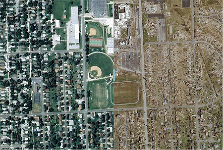
By now, most if not all of us know what happened in Joplin, Missouri, on Sunday, May 22, 2011: the deadliest tornado in the modern era slashed across the city, killing at least 125 people. Now, a clever, interactive sleight of hand put together by The Hartford Courant enables readers to view the remarkable destruction in before-and-after satellite images.

The image above is a screen capture of the before and after photos. A slider that you control, visible in the middle of the photo, separates the two images on the interactive version of the page: slide it right and you can see a full screen image of what southeast Joplin looked like before the violent EF5 tornado hit; slide it left, and the before image disappears, revealing the carnage left behind. Right again, and the greenness of neighborhoods in late spring with trees full of leaves lining tidy streets, the high school standing proud, unfolds across the screen. Left again, and the life many Joplin residents knew peels away, replaced by block after block of brown debris and lifeless destruction, including the decimated high school. It’s like something out of The Wizard of Oz, only in reverse, and makes one wonder how it could be that more people weren’t killed.