Dual Pol Radar Shedding Light on "Wintry Mix"

A recent article in the New Yorker tried in vain to dissect and understand the term “wintry mix,” only to grimly report it’s a weather phenomenon vile and disgusting and that forecasters state it to cover their backsides when a variety of winter precipitation is to descend upon man.
Far from vile and disgusting, a wintry mix is just that: a mixture of winter precipitation—snow, sleet, freezing rain—falling from the sky. No more, no less. Its mention will return to forecasts this weekend as a moisture-laden storm in the nation’s midsection plows into Arctic air and treks across the inland South and into the East next week. Rest assured: research and new technology are ready and are allowing forecasters to view wintry mix in amazing detail, better than ever before, improving predictions of the phenomena by leaps and bounds.
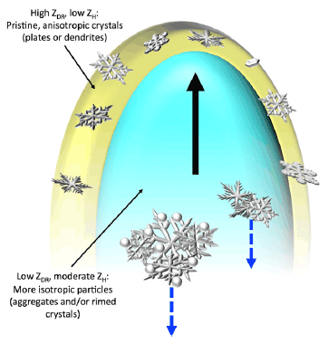
Recently published research on dual polarization (dual pol) weather radar in use, in a handful of AMS journals, is shining a spotlight on its capability to determine different types of precipitation falling at the same time, including the once-dreaded wintry mix. Instead of shying away from such forecasts, meteorologists using the nation’s network of Doppler radars, upgraded in recent years to include polarimetric technology, are beginning to get really good at chronicling the wintry mix in their forecasts.
While the New Yorker implied meteorologists disdain for the term, wintry mix actually is looking more beautiful than ever to scientists–so nice we put the words on the cover of the latest BAMS: “Snow Globe: Dual Pol Deciphers Wintry Mix.”
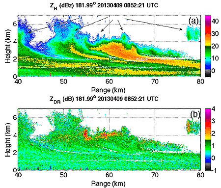
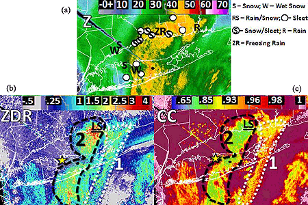
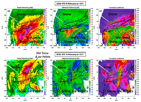
This cover article in BAMS, by Picca et al., looks at New England’s monster blizzard of 9 February 2013, which unloaded more than 3 feet of snow on much of central Connecticut and Long Island. Dual pol radar’s unique modes deciphered the wintry mix inside an intense snowband producing lightning and snowfall rates of 3-6 inches per hour.

DualPol_BAMS7
A composite of products from the dual pol radar on Long Island, New York (KOKX) shows reflectivity (ZH; top), differential reflectivity (ZDR; middle), and correlation coefficient (CC; bottom) of a heavy band of now and ice in the Northeast blizzard of 9 February 2013 (from Picca et al., BAMS). (Top) Reports of precipitation types around the time of the radar products provide ground-truth to the radar signatures. The speckled areas of reduced CC in southern Connecticut and around KOKX are a result of ground clutter. The black dot indicates the location of KOKX, and the star represents the location of the Stony Brook University surface observations. The dashed and dotted outlines indicate the two areas 1 and 2 of mixed phase precipitation. The underlined “LS” is the location of a “large sleet” report.

 
A similar article in Weather and Forecasting, by Griffin et al., documents for the first time polarimetric radar signatures of the same intense convective band of snow. The transition zone from freezing to non-freezing air (0°C isotherm) was exceptionally distinct in the radar signatures.
PPI displays of the polarimetric variables at (a)–(c) 2216 UTC 8 Feb and (d)–(f) 0236 UTC 9 Feb 2013 at 0.58 elevation. The 08C RAP model TW at the surface is overlaid (boldface, dashed). At 2216 UTC, pure dry snow was located within colder temperatures north of the 08C isotherm, while wet snow and mixed-phase hydrometeors occurred within warmer temperatures south of the 08C isotherm in (a)–(c). The solid black line indicates the location of the 1448 azimuth RHI. At 0236 UTC, dry snow was predominant, while wet snow and ice pellets were also observed within the max ZH region, within negative surface temperatures, north of the 08C isotherm in (d)–(f).
Displays of the polarimetric (i.e., dual pol) variables at (a)–(c) 2216 UTC 8 Feb and (d)–(f) 0236 UTC 9 Feb 2013 — during the Northeast blizzard (from Griffin et al., WAF). At 2216 UTC, pure dry snow was falling within colder temperatures north of the model-indicated 0°C isotherm (bold black dashed line), while wet snow and mixed-phase hydrometeors occurred within warmer temperatures south of the 0°C isotherm in (a)–(c).  At 0236 UTC, dry snow was predominant, while wet snow and ice pellets were also observed within the max ZH region, within below-freezing surface temperatures north of the 0°C isotherm in (d)–(f).

 
In the Journal of Applied Meteorology and Climatology (JAMC), the article by Kumjian et al. discusses the use of intensive radar measurements to study the finescale structure of more than a dozen Colorado Front Range snowstorms. And in Monthly Weather Review, Geerts et al. explain in their article how a specifically synthesized dual Doppler radar technique in an airborne platform was able to directly measure hydrometeor vertical motion, improving the accuracy of the radar.
CSU-CHILL RHI along the 181.998 azimuth at 0852 UTC 9 Apr 2013 for (a) ZH and(b) ZDR. Arrows show the locations of generating cells.
Vertical slices through a 9 April 2013 Colorado snowstorm from Colorado State University’s CHILL dual-pol radar show (a) reflectivity (ZH) as well as (b) differential reflectivity (ZDR), which indicates particle shape and size (from Kumjian, JAMC). Arrows show the locations of generating cells.

 
Conceptual model of a vertical slice through a generating cell with a shroud echo with example particle types present. The shroud of large ZDR and low ZH values (yellow color) indicates the presence of pristine anisotropic crystals with platelike or dendritic habits. The core of the generating cell (bluish color) is characterized by more snow aggragates or rimed crystals, the larger of which are descending (blue dashed lines) The core is also where the strongest updraft speeds (and thus supersaturations with respect to ice) are located, indicated the black vertical arrow).
In Kumjian’s JAMC article, a conceptual model of a vertical slice through a generating snow cell reveals example particle types. The yellow color indicates the presence of pristine anisotropic snow crystals with platelike or dendritic habits. The core of the generating cell (bluish color) is characterized more by snow aggragates or rimed crystals, the larger of which are descending (blue dashed lines) The core is also where the strongest updraft speeds (black arrow) are located.